Day 1: Bar Harbor

"The mountaintops are barren of trees, covered in rock. I shall name this the Island of Desert Mountains."
- Samuel de Champlain (September 5, 1604)

Our journey to Mount Desert Island started back in March 2012, in New Haven's Union Station. Waiting for the 8 PM bus to Boston, I browsed a kiosk of travel brochures at the end of the station terminal, flipping through brightly colored photos of the Mystic Aquarium, the White Mountains, and the Portland Head Light. There was always a strong desire to go North, in those years. College had become a lame duck session, and Jane and I pondered destinations for the weeks between our meaningless final exams and nearly-as-meaningless commencement exercises. I brought with me to Boston a trifold brochure about Acadia National Park, paradise situated on a rocky granite island in the east of Maine. We got as far as plotting cottage rentals and driving routes before the price of the endeavor stymied us. We were even thriftier in those days, and too young to rent a car thriftily.

Maine has loomed large in the imagination ever since those years in New England. Even after moving away from Connecticut, I frequently thought and  wrote about the changing of the seasons, the wind sweeping down from the autumn sky, and the vivid, burning woodlands; landscapes transformed overnight, turning everyday life into mystery, every walk into an adventure. I longed to see that transformation again, and to see in its most sublime and northerly form. All of which is to say that the circumstances of this trip were set long ago - long before Iceland and Scotland and even Baltimore, Maryland.  The October of our 25th birthdays, even if only for a brief weekend, has belonged, and forever will, to Mount Desert Island in Downeast Maine.

Mount Desert Island, like many places in America, sits at a busy intersection of human and natural history. Shell middens dotting the shoreline are a vivid reminder of the Eastern Algonquian peoples who sailed and fished along the coast of the island they called Pemetic ("The Sloping Land"). This land served as a  cultural battleground for French and English colonists, an object immortalized by the painters of the Hudson River School, and a retreat for prominent Americans of the Gilded Age and the Roaring Twenties. The mountains of Acadia date back to an Ordovician collision, their granite tops so weathered and worn as to be memorialized by Champlain in his sailor's journal. Comparatively recently, glaciers roared across the island in the Pleistocene, carving elaborate valleys that have since become deep ponds flanked by meadow, moraine, and woodland. This is an island of fearsome beauty; of nature living and breathing across the ages. It remains home to eighth-generation colonists and fourth-generation lobstermen, as well as more seasonal inhabitants: in the wintertime, whale-watchers; in the summertime, an influx of homeowners; and in the autumn, the leaf-peepers. Jane and I join the latter's ranks.

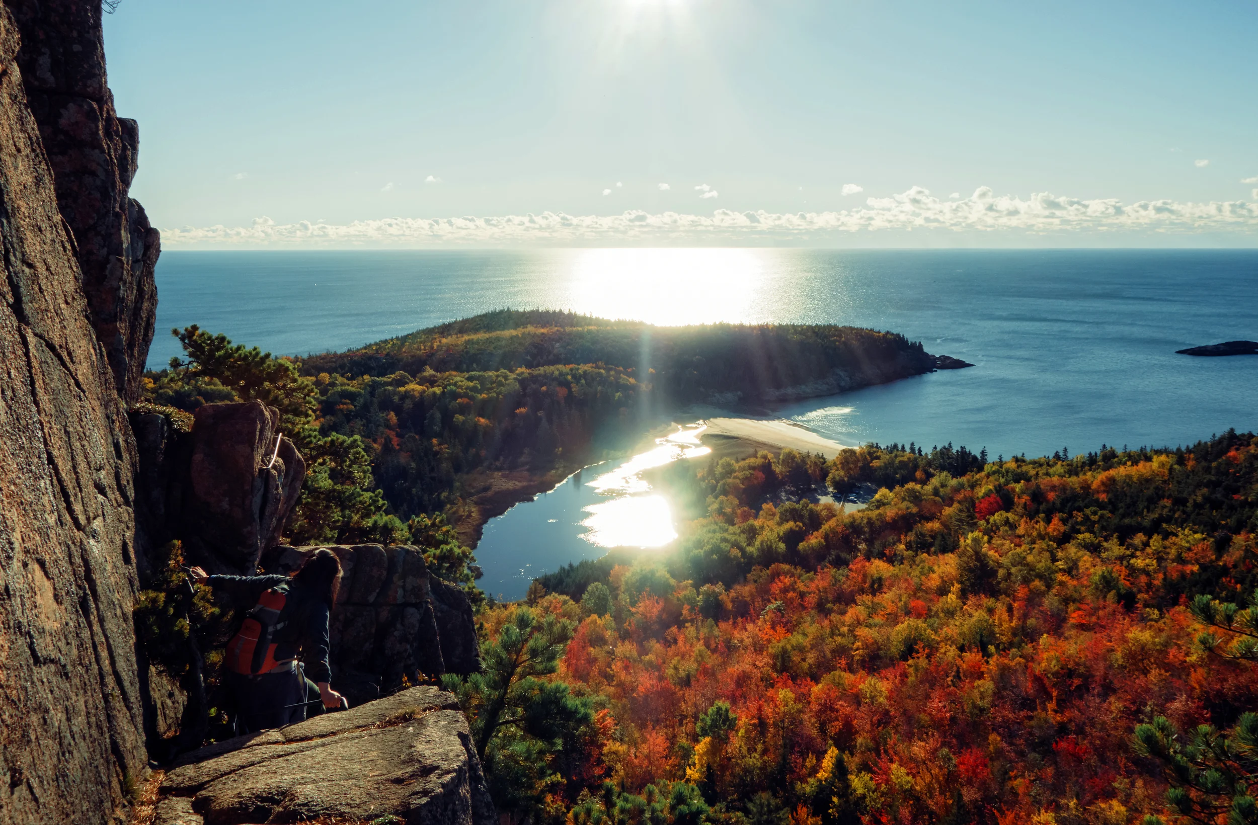
Having caught a morning  flight to Bangor from Washington, D.C., Jane and I cruise down the highway toward the coast of Eastern Maine. We pass the towns of Ellsworth and Trenton, and cross the road bridge over the Mount Desert Narrows; we are in Acadia proper around noon. The autumn rain that pitter-pattered on our windshield as we left Bangor has dissipated; the skies are strewn with cloud, desperately blue and beautiful. The woodlands we left in Maryland have just begun their deciduous transformation; here, we have arrived at the peak of the season. The hillsides are lined with flaming birch, oak, and maple, admixed on the higher slopes with the dark rich hues of spruce, pine, and fir. The air is cool and crisp. We take a long, scenic route into Bar Harbor, cruising southeast along the first portion of the Park Loop Road and returning north via Schooner Head Road. Along the way, we stop at an overlook commemorating the Great Fire of 1947. We have arrived on its 68th anniversary to the day; indeed, the woods pouring west to Hulls Cove, north to Bar Harbor, and east to Champlain Mountain look very much ablaze. We stroll the marshy path in the Great Meadow two miles south of Bar Harbor, and sit beside Beaver Dam Pond in the shadow of the Champlain's wooded hillside. At Schooner Head, we walk down to the battered shoreline of the promontory. Jane tiptoes her way along the rocky cliff, and I photograph her standing on the ceiling of a sea cave flooded by the high tide, its entrance just visible beneath the surf. Across the small cove are seaside mansions perched atop the rock, barely shrouded by the protective tree line. We walk along the coastline, leaping over ledges and gaps in the rock. A light rain begins to fall, rendered almost imperceptible by the waves crashing upon the rock around us. We creep back up the forested path.

Driving north now, we pass the Jackson Laboratory - a genetics institute founded on the island in 1929 - and soon enter the quaint little  town of Bar Harbor.  We will be staying the next three nights at the Yankee Lady Inn, a charming Victorian bed-and-breakfast run by Ms. June Chaplin, whose family has lived in Bar Harbor for generations. "Come in, do come in!" She  ushers us with our big backpacks into the foyer of her little house, and I know instantly we are in a good place. The stairwell is lined with topographic and naval maps of the island and its environs, and the wallpaper is dotted with a leaf motif. On the living room table sits a stack of crystalline rock samples, and in the dining room, a gigantic map of the continental U.S. stretches across the back wall. The ceiling is painted so that we are sitting beneath a lily pond as June treats us to afternoon tea and coffee. She takes out her maps and shows us good places to walk on the island. I ask her about the submerged path to Bar Island, and whether we can make it across the water before sunrise (the day paper's tide table forecasts low tide at 8 AM tomorrow). "Oh, you'll be fine," she says with a grin. "Just wear your boots. And don't tell anybody I told you."

We unload our bags and set off for a stroll around town. We walk two blocks north to Bridge Street, a gravel path that terminates at the water. It is high tide, and Bar Island's namesake sandbar is hidden beneath the waves gently rolling in from Frenchman Bay.  We sit on the beach and gaze longingly at the pine-forested island across the water. Two blocks to the east, we stroll along waterfront inns and restaurants - charming, rustic buildings ported in from another century. Every establishment is selling lobster, even the coffee shop where we stop for tea and a fruit smoothie. We grab a bench in the village green and sip on our drinks as we watch the boats go by in the harbor.

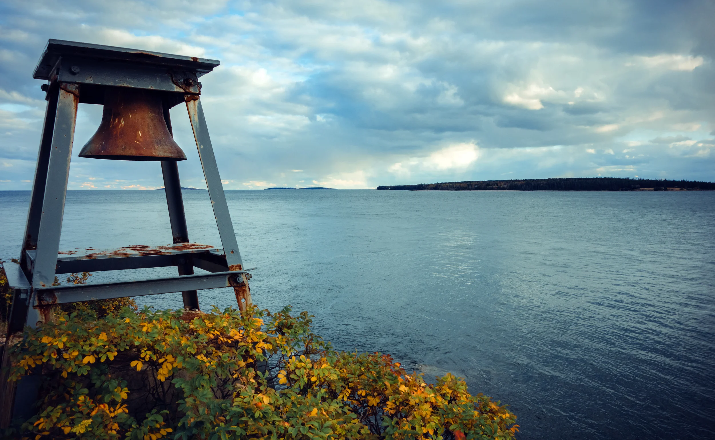
A late afternoon rainstorm blows in as we walk along the harbor shore path. The wind gusts whip the bay into a frenzy, and whitecaps come crashing toward the docks. A bell buoy somewhere off in the harbor is clanging furiously, and a gray mist blots out the setting sun. We throw the hoods up on our windbreakers and make our way back along Cottage Street, ducking into The Thirsty Whale for an early dinner: two lobster rolls - toasted buns piled high with fresh claw meat - with a side of New England chowder. On our way home, we stop in the Hanaford Supermarket to stock up on trail food - a loaf of bread, a block of cheese, and a bottle of juice.

Back at home, Jane takes a nap while we wait for darkness to set in. I am determined to do some astrophotography work on Acadia's Atlantic coast, and Jane insists on accompanying me. I get the impression that this is more for my safety than for her own enjoyment. At 8 PM, we hop in the car and drive back down Schooner Head Road. As we leave town, the forested road grows dark; we turn on our high beams. At Park Loop Road, we turn south and pass a park entrance station, totally deserted. We peer ahead into the night as the road curves with the shoreline, through tree stands and along rocky cliffs. I am trying to find the right parking turnoff among many, on an unlit sea cliff road that we have never driven, in pitch-black darkness. A light rain continues to fall. Jane is audibly frowning next to me. "This one. I think it's this one," I say, as we creep up on a turnoff to a parking lot. "You think it's this one?" Jane asks rhetorically. It is not this one. Nevertheless, I am beginning to realize that my chance of finding my favoured shooting spot is low compared to my chance of driving off a cliff or walking off a boulder path into the ocean. We park the car.

It is utterly dark, and I have committed the cardinal sin of astrophotography: no headlamp. I coax Jane into at least letting me hop out of the car to determine how hard it is raining, and whether there is any cloud cover. Unfortunately for her, there is only a slight drizzle in the air, and when I look up, I see the Milky Way bright and brilliant, strewn like a riverbed of stars across the southeast sky. Jane exits the car muttering, but even she grows silent when I point up. We descend the parking lot slope by the flashlight on my phone, and skitter across the dangerously dark and winding roadway. On the other side, we descend a rocky footpath through the pines, down towards the cliff edge. We can hear the pounding of the surf just below us, but we can barely see two steps in front of our feet, let alone where the earth drops away to ocean. The path is uneven and wet; small puddles are gathering in the rock, and small streams roll down the hillside, freshened by the falling rain. "If I die," Jane begins hypothetically. She does not verbalize the remainder of her thought.

We eventually come to a break in the trees. The Atlantic waves are roaring in the dark around us, and we mutually agree that we do not need to risk following the cliff edge any further. "Tourists follow undeveloped footpath at night, plummet to watery death," Jane reports.  I set up my tripod and go to work, knowing that every minute I spend here is an incremental strain on our relationship. Dearth of headlamps notwithstanding, I have, at least, learned one lesson since our night at the Grótta Lighthouse in Iceland - I've saved a preset for night shooting, and I am able to focus on framing my shots without fumbling with camera controls in the dark.

As the camera does its work, in 30-second intervals, our eyes begin to accustom. To the north, I can see the stars glowing over Schooner Head and, where it curves inland, the shore of Sand Beach. In the distance, the smooth pelagic horizon is met perfectly by the blue-green glow of the night sky; you can almost see the stars shine upon the ocean as if it were a mirror. Miles from us , a series of signal buoys emit a calming red glow through the darkness of the watery expanse. To our south, the center of the galaxy curls up skyward from a stand of pine trees, glowing with its density of stars and the golden-purple, hazy fluorescence of faraway nebulae. "I haven't seen stars like this before," says Jane, finally awestruck into silence. We are left with only the howl of the night breeze; the steady roar of the waves; the patter of raindrops on rock; the interval snap of the shutter. "Can we go now?" Jane finally asks. We drive back to town as I thank her profusely.

Day 2: Quietside

The next day, we awaken to the placid blue of pre-dawn, in the second-story bedroom of an old Victorian house in Bar Harbor. The green-decored room is comfortably warmed by a space heater, but I can feel the frosty morning air radiating from the window panes. We don our cold weather gear (for the first time since Iceland) and descend the creaky staircase, stopping on the front porch to lock the door.  Back along Bridge Street, as we descend the dirt driveway down toward the narrows, we are stunned to find a dark, half-mile sandbar rising up out of the water.  We stare at the water receding from the path, which is at least thirty yards wide in places, just barely uncovered in others. Celestial bodies pull upon every atom of the planet, generating ocean waves with lengths spanning half the globe, before which all the Earth's shorelines, safe harbors, and, indeed, continents, are just incidental bumps in the road - land to be acted upon, submerged. In the dim light, a flock of Canada geese flies perpendicularly across the bar, unusually quiet for their kind. They are partway through their southward migration along the Atlantic flyway; in a few weeks, they will make water landings in the lakes and marshlands dotting the Chesapeake Bay, their home for the winter months. We skirt the tide pools and the bushes of beach rose and walk across the bar tenuously, aware that we only have a certain amount of time to spend on the other side.

On Bar Island, we climb a footpath through the trees, past several abandoned orchards and farmsteads. The path eventually branches; a wooden post has two arrows pointing in different directions which are helpfully labeled "Trail". We turn uphill and climb through a stand of spruce and pine, emerging into a clearing with needles clinging to our jackets. There is a massive cairn of rock and debris here; we look around, confusedly, at the treeline rising above us. This does not feel like a summit. But just ahead, there is a break in the forest with views descending south toward Bar Harbor. Out of view to our east, the sun has just crested the Atlantic, and its rays illuminate the town across the water. A fleet of white sails and Victorian-era façades gleam like gold under the bald summits of Cadillac and Champlain Mountains. We sit there for a few minutes, enjoying this pretty sight, before returning to the forest.

Back downhill, we continue east in search of another view. The trail winds through the upland forest before deteriorating into an invisible track among the roots. We creep through the branches and find ourselves at a dead end - an overgrown cliffside on the eastern end of the island; we can just barely see the glimmer of seawater through the canopy of leaves. We crawl forward on hands and knees and sit on the rock ledge; the morning light is streaming through the autumn foliage, illuminating our little space beneath the trees. It is a golden room of perhaps six square feet, and it is one of the loveliest forest scenes I have ever seen. On our return, we get lost in the thick forest growth. We contemplate emerging from the woods hours later to find the sandbar flooded by the tide, wondering how we will spend the day alone on the island. Fortunately, we soon find the track through the woods, and our dread dissipates. We descend to the beach and walk back across the water, stopping to peek in the exposed tide pools at the limpets and barnacles, the mighty strands of kelp.

Back at the house, June is busy in the kitchen. She treats us to a breakfast of coffee, juice, a bowl of fresh fruit, hot scrambled eggs, and pancakes topped with orange marmalade and butter. Nourished, we put our hiking packs in the car and drive west out of town. It is Sunday, October 18th, the date of the annual Mount Desert Island Marathon, and so today we will be avoiding the majority of Acadia proper in favor of the western half of the island - the "quiet side". We drive past Eagle Lake with its summer cottages and fishing piers, and follow the highway across Somes Sound, a glacial fjard (broader, flatter version of the fjord) that neatly divides the island into two lobes. The frosty blue morning has given way to brilliant sunlight and crisp, fresh air. On the north shore of Great Long Pond, we pull into a gravel parking lot at National Park Canoe & Kayak. The boats are sunbathing in front of a tiny cabin office, next to a rack of paddles and life jackets. No one is around; a sign on the door informs us that the office is closed for the season, and rentals can be paid for via honor system. We deposit our fee in a wooden envelope box and carry our baby-blue tandem kayak across the street to the boat launch. Faced with a team-building exercise, we laugh nervously. After I promise not to capsize her, Jane allows me to push us out into the water. We set off across the lake.

Jane, in front, is doing most of the paddling; I am just along to document the ride. The autumn air is cool and nipping at our noses; our fingers quickly turn cold, gripping the steel of the paddlebars. But the view is more than worthwhile; the clean blue water of the pond is ringed by trees and lakeside cottages. We paddle curiously toward the private docks and peer at these charmingly pastoral dwellings. All around us are the tufts of evergreens and the brilliantly red and orange birch and maple trees. Looming ahead over the water is Great Notch, and beyond it Beech and Acadia Mountains. We are paddle down the lake, long and narrow as a scratch, a finger-shaped scar in the earth, clawed out by the southern advance of Pleistocene ice. The sheer size and scale of this so-called "pond" is not apparent to us at this point, at eye level.  We do not go particularly far before the cold, the sun, and the diving, blue depths of the water convince us to turn around. On the roadside, a few onlookers have stopped their cars to admire the lake and, embarrassingly, to watch us kayak. "You two sure picked a damn fine spot for paddlin' on a Sunday morning!" one man yells to us from the jetty. We wave like British royals, trying hard not to disturb our combined center of gravity; the visual effect, I imagine, must have been quite comical. Back on shore, we entrust our boat to Mr. and Mrs. Baker, another couple visiting from Maryland. No strings attached, we say. Just two daft kids who are quite cold and strongly prefer to remain on terra firma.

We drive south from Great Long Pond, across the foothills between the lakes, to the trailhead beneath Beech Mountain. The short hike to the summit, which takes us through the mountain oak and up smooth-grey granite slopes, is quite refreshing after our hour on the water. We are back in our element. Jane climbs ahead while I photograph. We get our first good look at wild blueberry plants, which grow with reckless abandon all along the mountainside. In the fall, their crimson-red leaves are perhaps the most startling and vivid colors in the entire Maine countryside, and here they beautifully complement the soft pink of the mountain rock

I catch up with Jane where she has stopped to take in the view, on the northwest slope of the mountain. From the side of Beech Mountain, we can see the full length of Great Long Pond; miles away in the distance, we can barely see the indentation in the shoreline and the tiny jetty where we launched our boat. The Pond stretches nearly 180 degrees across our field of view, north to south, nestled in a broad valley. In the far distance over the hills, running parallel to us, are the shimmering lakes of Hodgdon Pond and Seal Cove Pond - more claw marks left by Mount Desert Island's ancient glaciers. I imagine the entire landscape before us submerged by a mile-high columns of ice - glowing blue mountains deforming the earth, crafting the valleys below us with their sheer weight. It all happened yesterday, if one measures in geologic time.

A few hundred meters further up the slope, we reach the mountaintop, heralded by a rickety old fire tower standing on the bald granite above us.  We are warm from the climb, and the wind whips around us, not unpleasantly. Jane climbs the fire tower. We stand on the south face of the summit and gaze out at the "Quiet Side" of Mount Desert Island. The little buildings of Southwest Harbor are in the distance, dots floating in ocean of many-colored trees. The sun is shining brightly now, and the Atlantic has become a sea of white light, silhouetting the Cranberry Islands just offshore.  The granite around us, too, is sparkling in the mid-day sun. Jane and I realize, belatedly, that we have not re-applied sunblock since 6 AM; our cheeks begin to feel tight. We finish the loop, following blue trail blazes painted on rock all the way down the mountainside.

From Beech Mountain, we return to the main roadway and head south, completing the last miles of the Mount Desert Marathon by car. In Southwest Harbor, there is a festive scene at the finish line - runners bundled up against the chilly October wind, sipping hot cocoa with medals in hand. We stop by one of the few places in town still open past the high season - The Quietside Café and Ice Cream Shop. I readily admit to Jane that I am most intrigued by the latter portion of the name. We order big bowls of fish chowder, and share a slice of wild blueberry pie à la mode. The restaurant owner is leaving for Florida at the end of the week. The gift shop next door, where we peruse little trinkets and island-themed decor, is having a closing sale. The shopkeeper is moving to California for good; we chat for awhile about Orange County, where her children and grandchildren live.


We drive west now along the southern shore. It is, indeed, much quieter here than the Acadia and Bar Harbor side of the island; we pass precious few cars as the autumn sun begins to drop toward the horizon. We stop at the stone beach campground at Seawall. I leave my camera on the tripod as Jane walks determinedly out into the tidepools, like a television news reporter pursuing live interviews among the resident colony of herring gulls and black cormorants. A westerly wind is pushing the clouds before us, sending the sunbeams spiraling; the afternoon light shines down on the lovely scene before us, sifting between the pine trees across the cove. I stand on the shore, photographing as the light changes minute by minute. Jane combs the beach for anything to pique her interest, eventually settling down on a rock to assemble a collection of periwinkle shells. She walks over and gifts these to me before wordlessly waddling away.

Our last stop of the day is the Bass Harbor Head Light, near the southwest point of the island. We arrive on the headland to hear the Atlantic dashing upon the rocks. Above them on the cliff, the signal bell is clanging away dutifully, its rings carrying to the distant islands. A short trail leads from the parking lot down to the side of the cliff, where the lighthouse is visible across a field of boulders. We scramble over and under these lumps of pink granite, tinted a beautiful, dusky color by the light of the setting sun. There is a good crowd here; we dodge photographers assembling their tripods for sunset shots of the Head Light, and wayward toddlers climbing and jumping between the rocks, oblivious to their nervous, trailing parents and the crashing ocean waves below them.

Jane and I find a little alcove in front of a particularly large boulder and duck down safely out of sight of the firing squad. There we sit together, shielded from the wind, our bottoms on granite, our feet in a little saline puddle. The sun is sinking now toward the horizon, silhouetting the offshore islands and bathing the cliffside in a warm, orange glow. The lighthouse is beaming a soft, reassuring red, on and off at five-second intervals, and somewhere high above us, the signal bell is ringing happily in the evening breeze. We watch as the photographers ply their craft.

It is mid-October, and the sky darkens quickly. Eventually, we rise, stiff-legged, from our hiding spot and make our way back across the cliffs. Jane flicks on the headlights as we drive back from the southwest corner of the island. A few minutes away, back near Seawall, we stop to buy dinner at the irresistibly named Charlotte's Legendary Lobster Pound. It is dark and cold now, and Jane huddles by a space heater next to the trailer while I order at the window. The proprietor, Charlotte, informs me that she is out of whole lobsters but would be glad to sell us lobster rolls stuffed with claw meat. She sweetens the deal with several pounds of mussels and freshly drawn butter. We walk around the trailer lot as we wait for our food. A sign by the road says "LOBSTER XING"; we look, but find only a family of white-tailed deer grazing in the field behind the lot.

Back at the house, we sit on the ground and dig into our bucket of steamed mussels, cups of coleslaw, and lobster rolls. It is one of the more unique dinners that Jane and I have shared - a sumptuous seafood feast on the wood-paneled floor of an old Victorian house. It is 8 PM when we finish eating, and completely dark outside our window but for the glow of the old streetlamps that line the sidewalk. We go downstairs to sit for awhile in June's living room, pouring over her old Friends of Acadia magazines and examining the chunks of gneiss and schist and marble on her coffee table. On the wall hangs a photo of several boys standing in the woods, looking quite ruddy-cheeked and dapper in the snow and their Christmas sweaters. One, the youngest, is preparing to lob a snowball at the camera. Most of her children and grandchildren have moved away from Bar Harbor, June explains to us a few days later over breakfast. Now they occasionally visit, but not usually during winter. January and February, after the holidays have passed and the island remains blanketed by snow, is when most elderly folk in Bar Harbor pass away, June tells us. "I could never bear to leave, though." She shows us a collage of her house buried under several feet of snow, each photograph neatly labeled with the date and year of the storm. "Just look at what I'd be missing."

Day 3: Acadia

Before dawn, we leave Bar Harbor again, heading south. Jane is irritated with me; it is waffle day at the Yankee Lady Inn, and I am making her miss waffles to catch sunrise. "It's bed-and-breakfast, not bed-and-leave-before-breakfast!" She pontificates around this central point the entire drive down.  I admire the woman for her unshakeable principles. We follow the winding Park Loop Road, officially entering Acadia National Park on the island's rocky Atlantic coast. Retracing our steps, we pass the parking lot where we stopped for astrophotography two nights before; it is much less foreboding in the early morning light. Near the southeastern tip of the island, we pull into a trailhead parking lot at Otter Cliff and set out on a 5-mile loop hike that will take us north along the coast and back south via the summits of The Beehive and Gorham Mountain.

The sun creeps over the ocean and casts a golden light over us as we walk along the cliffs. At Otter Cliff and Monument Cove, we climb down to the stone beach, its surface littered with rock cairns. The air warms up quickly as we approach Thunder Hole; at low tide, its hand-railed causeway is silent, raised high above the lapping ocean waves. After we pass Sand Beach, we descend from the cliff, following the park road to the trailhead for The Beehive, where one park ranger is sitting in a pickup truck and another is performing maintenance on one of the entrance signposts. We turn into the forest.

Here the climb begins, at first up through the pine forest and along the smooth rock slopes that we have grown quite used to. Soon, it becomes a scramble up a series of granite ledges. We shed our jackets and follow the blue trail blazes around corners and cliffsides, hugging the rock wall, our feet dangling over the forest below us.  Along the narrowest and steepest portions,  handrails are placed to assist the climb, and there are a few brief series of iron ladder rungs up the side of the mountain.  We briefly wonder whether the park rangers at the trailhead have gotten around to maintaining the rest of the trail. In spite of this,  I am enamored by the climb, the heights, and the open air - not as worried, in any case, as Jane, who has again transformed into safety-officer-in-chief. "Stop taking pictures! Watch where you're going!" she says. "Uh-huh," I reply.  As we climb, the view to our east opens up; the forest all around us, and Sand Beach tucked in a cove formed by Schooner Head. In the distance to our south, we can see the headland jutting out at Otter Cliff, where we started our walk. At the summit, we sit on a rock facing Champlain Mountain and Frenchman Bay to the north, and breakfast on slices of cheese and bread. There is no one else with us on the mountain.

We turn south now, descending the Beehive from its back and continuing along the rocky spine toward Gorham Mountain. The woodland path climbs up and down the mountain, opening intermittently into barren clearings with startling ocean views. Autumn is in full swing, a kaleidoscope of colors coating the landscape before us - the reds of the wild blueberry brush, the oranges and yellows of the deciduous trees, the greens and teals of the pine forest, and the shining, cerulean blue of the Atlantic Ocean. At the summit of Gorham Mountain, we take another break before following the rock cairns down the side of the mountain, the granite glowing now in the mid-morning sun. We emerge from the mountain path back onto the side of Park Loop Road, and backtrack along the Ocean Path, reaching our car at 11 AM.

Pulling out of the lot, we continue along Park Loop Road, which soon becomes curves north, becoming one-directional as it re-approaches the park entrance. Our stop for the afternoon is Jordan Pond; we head into the Jordan Pond House, which sits, with its big lawn opening onto the shore, on the south end of the pond with a big lawn. In the summer, the place would undoubtedly be swarming with tourists and walkers enjoying afternoon tea and popovers (a light, fluffy, hollow roll - not unlike a Yorkshire pudding - served with butter, cream, and fruit jams), and tables and tents would pack the lawn. Today, despite the gorgeous scenery and fine weather, there is hardly a soul at Jordan Pond; I have made a lunch reservation, but find it totally unnecessary. The off-season comes early here in Maine. We sit on the mezzanine overlooking the main dining hall and enjoy a quiet lunch of chowder and shepherd's pie accompanied by crab-and-artichoke dip spread on crostinis.

After lunch, we walk down toward the shore and take in the view of the pond - another north-south finger lake carved by an ancient glacier, and now a natural reservoir for drinking water for the island's communities. To the north, looming over the pond are two breasts of granite - the North and South Bubbles; the hillsides all around are coated with golden foliage. "Do you think they do weddings here?" I hear Jane murmur somewhere behind me as we cross the lawn behind the restaurant. "Hm?" "Oh, nothing..." she says.

We stroll along the periphery of the pond, counter-clockwise. The east shore is an easy dirt path with a few footbridge crossings over narrow streams feeding into the lake. I stop to photograph the foliage while Jane walks on ahead. At the north end of the pond, we turn uphill and begin an arduous rock scramble - much tougher than the well-manicured trail up the Beehive - up the skirt of South Bubble. Climbing from boulder to boulder, at times on hands and knees to take load off of our ankles, we ascend the steep path out of the forest. Near the top, we pull ourselves onto several tall rock ledges - no handrails or ladder steps here. Climbing out of a crevice, I become comically wedged in the space between two rocks. Jane laughs while I try to extract myself; I blame it on my tripod, not my butt.  "I'm just glad I've been doing pull-ups," she says. Just as I crawl up out of the crevice, we encounter a Chinese family coming the other way. The immediately ask us, in Chinese, for directions. "Is that way steep?" I am quite literally heaving and panting at this point. I glance down at their feet - they are all wearing flip-flops, Lord knows why. "It's... not... so bad," I manage to gasp. They look at me incredulously before deciding to proceed. We never saw them again, by which I can only assume they made it down the mountain safely.

On top of South Bubble, we are greeted by sweeping views over Jordan Pond. To our east, just under us, Park Loop Road curves along the hillside through the forest. Far to our south, we can just make out a speck at the head of a grass lawn - the Jordan Pond House and our parked car. We stare at them wistfully. Far beyond, we can see clear to the Atlantic Ocean and the other islands in the bay. It is a pretty sight, and I take a few moments to capture one of my favorite images of the trip - the above 20-shot panorama of Jane taking in the view. We follow the granite along the summit, coming soon to Bubble Rock - a massive, car-sized boulder perched perilously on the edge of the mountain. A glacial erratic deposited by the same glaciers that shaped Jordan Pond to our south and Eagle Lake to our north, not unlike the boulders we saw at the summit of Old Rag Mountain in Virginia, or the massive rocks strewn across the middle-of-nowhere lava floodplains of Iceland. It looks like it could topple over and crash down onto Park Loop Road at a moment's notice. "Go push on it," I say to Jane. "Hell no," she replies.

After resting for a few minutes, we climb back down the way we came, back down to the pond. My right ankle is admittedly feeling tight at this point, and I descend carefully, using my hands more than I would have otherwise. A sprained ankle or, worse, a nasty fall would certainly put a damper on our vacation. Back on the pondside trail, we continue west and then south, finishing up the loop. The western shore of the pond is even prettier than the east, especially in the golden, mid-afternoon light. The path crosses a picturesque log bridge with a high arch, then hops across a series of boulders before transforming into a boardwalk through the trees and lakeside marshland. We stroll along the boards, the clonking of our boots accentuating the gentle lapping of water on the shore and beneath our feet. With the sun hidden from our view by the hillside and the trees, the endless, twisting boardwalk becomes hauntingly beautiful. It reminds both of us of Channelwood, a world of trees and water from the computer game Myst.

Back at the car, we leave the Pond House behind and continue north, turning off the take the winding road toward the summit of Cadillac Mountain. It is past 4 PM now, and we are heading to the Blue Hill Overlook to watch the sun set over Mt. Desert Island. At the overlook, we find a nice herd of tripods and photographers perched against the railing. We walk north and climb the granite slope out of the parking lot; just thirty meters away, we find unobstructed views of the landscape dropping away to our west, and not a soul in sight (a tip courtesy of Mt. Desert Island native James Kaiser and his travel guide Acadia). We find a rock to sit on, and I set up my tripod for a timelapse while Jane explores the brush on the hillside. At the top of the mountain, the wind is biting, and it gets colder and colder as the sun disappears toward the horizon; we put on our heavy coats and pull our hoods over our heads. Jane is sitting next to me now, waiting patiently as I photograph minute-by-minute over the next hour; the mid-autumn sunset is fast, but not fast enough. As it grows dark, I pack up and we walk back to the car. Our noses are both chilly, and my gloveless fingers are more than a little numb.

Back in Bar Harbor, we stop by the supermarket again to buy dinner. We are finally getting tired of chowder, and our dining options are getting more and more limited by the day, as the town prepares for its winter slumber. We arrive back at June's house with a full rack of barbeque ribs, coleslaw, macaroni & ham salad, and more cheese and bread; June graciously allows us to prepare our spread in her dining room. "You two are almost my last guests of the year!" she tells us. "I've got one more couple coming in tomorrow, and a single man visiting from Germany later in the week... and that's all." We munch on ribs while June watches TV in the living room.

The next morning, Jane sleeps in. I take the car, driving in pitch-black, back to the summit of Cadillac Mountain, with its views over Bar Harbor, Frenchman Bay, and the Porcupine Isles. For most of the year, the barren top of Cadillac Mountain is the first place in the entire United States to be touched by the rays of sunrise, and on a clear day, the views eastward can extend all the way to Nova Scotia and the Bay of Fundy. It is, however, not a clear day; there are a few other sunrise-catchers pacing the slopes around me, and a light drizzle comes down on us as we wait in the near-dark. A faint, pink glow appears in the cloud layers over the ocean to the east, but the sun denies us an appearance. The blue light grows swiftly brighter, and soon I am the only one there, sitting in the rain against my boulder on the hillside.

Back in Bar Harbor, we have one last breakfast with June, who has made French toast with maple syrup, sausages, and scrambled eggs, served with coffee, milk, and juice. She notices how quickly Jane devours her plate, and asks if we would like seconds. "Oh, no thank you, I'm alright!" Jane lies. We both agree later on that June's cooked breakfasts were our favorite meals of the trip. After breakfast, we pack our bags, bid farewell to our hostess, and head out. We take another stroll around Bar Harbor (I am looking for an antique map of the island to match my map of Iceland; I later find it, but only on Etsy), which is all but deserted on this Tuesday morning,  a strange, ghost version of the lively town we saw on Saturday with its throngs of tourists and marathoners. Our souvenir shopping complete, we return to our car and drive back along State Highway 3, off of the island, headed northwest to Bangor. At Bangor's tiny, 10-gate airport, we are the only people in line for security screening; we take a nap in the quiet terminal as we wait for our flight home to Baltimore.