Vermont: The Green Mountains

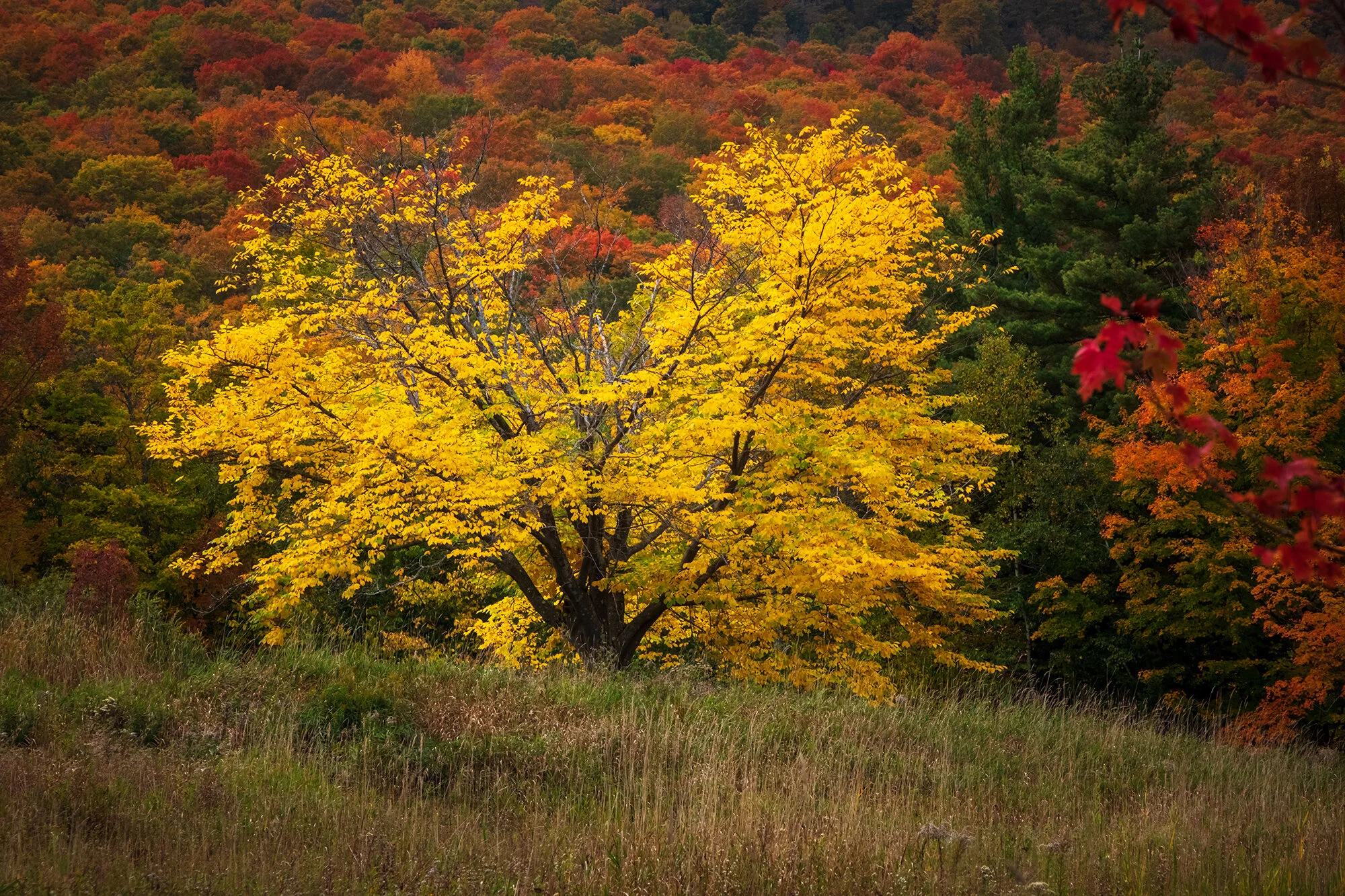
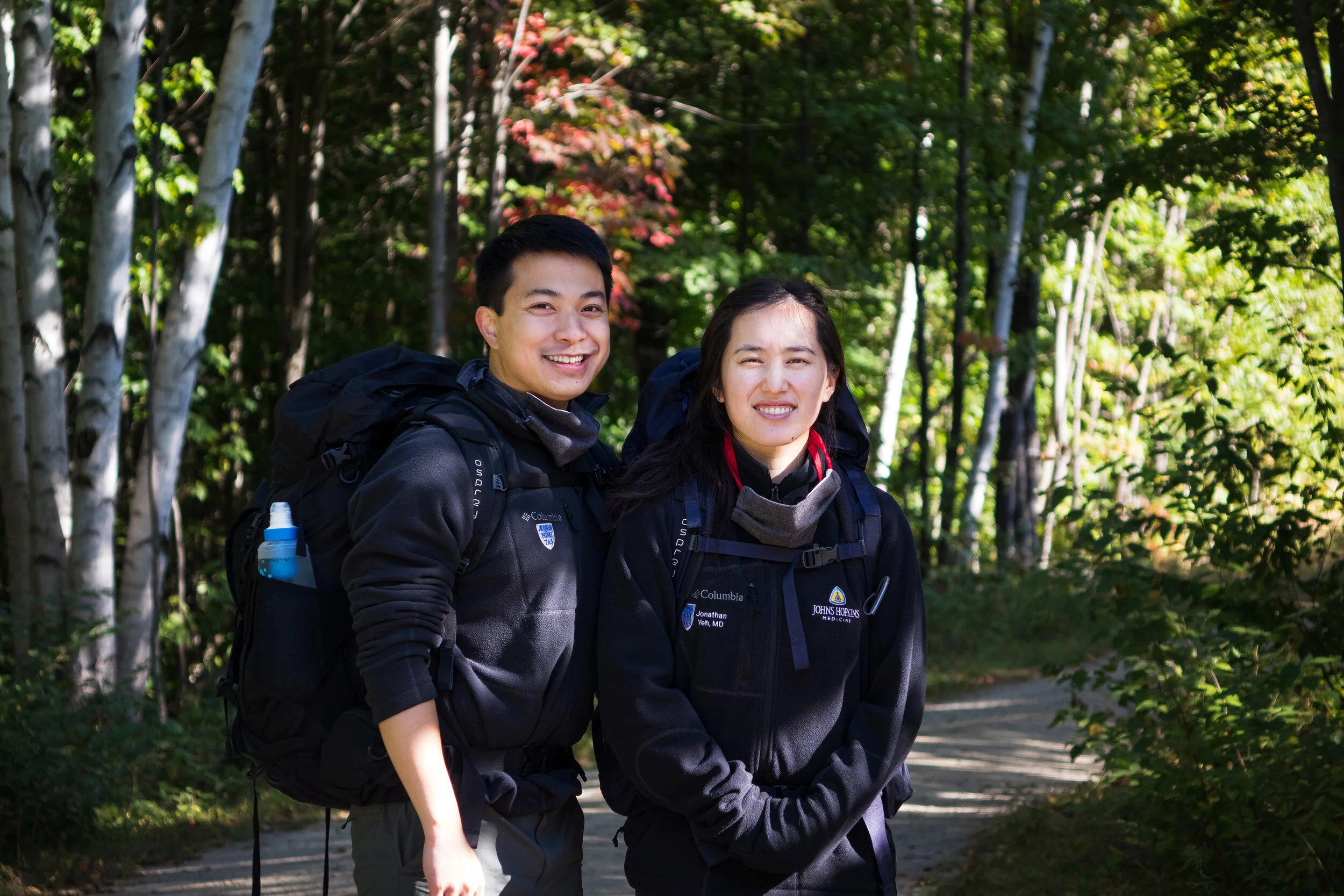
The next morning, Jane and I head out early to photograph Stowe’s church at sunrise. The clouds are socked in, so the morning light is quite subdued; the church is still quite beautiful, though, against its backdrop of bronzed autumn trees and mist on the neighboring mountains. We also park in the lot behind the church and walk down Sunset Street to the trailhead for Sunset Rock - a small westward overlook across the town’s main street after short climb through the forest. The light is quite flat and miserable, so we take a few photos and selfies before descending the hillside to grab breakfast. Stowe, for all its pomp and popularity, is no larger than most of the small villages we’ve driven through in the past day; a single main street, a single traffic light intersection, and a few coffee shops, restaurants, and stores. It’s hard to imagine how crowded the area gets throughout the day in autumn, but we start to get a sense: by eight in the morning, several of the local breakfast joints have lines stretching out the doors and onto the sidewalk. Jane and I grab croissants and drinks at the nearby coffee shop and eat these on a nearby picnic bench before deciding to ignore Stowe and Smuggler’s Notch, opting instead to get out of town as soon as possible. We turn off the highway onto some backroads in Stowe Hollow, where we find beautiful, fog-laced hillsides covered with autumn foliage. But it is an easy consensus: Vermont has many scenic places, idyllic villages, and beautiful autumn landscapes. Stowe itself is far, far overrated, especially when it is a parking lot. Don’t center your photography travels around Stowe.

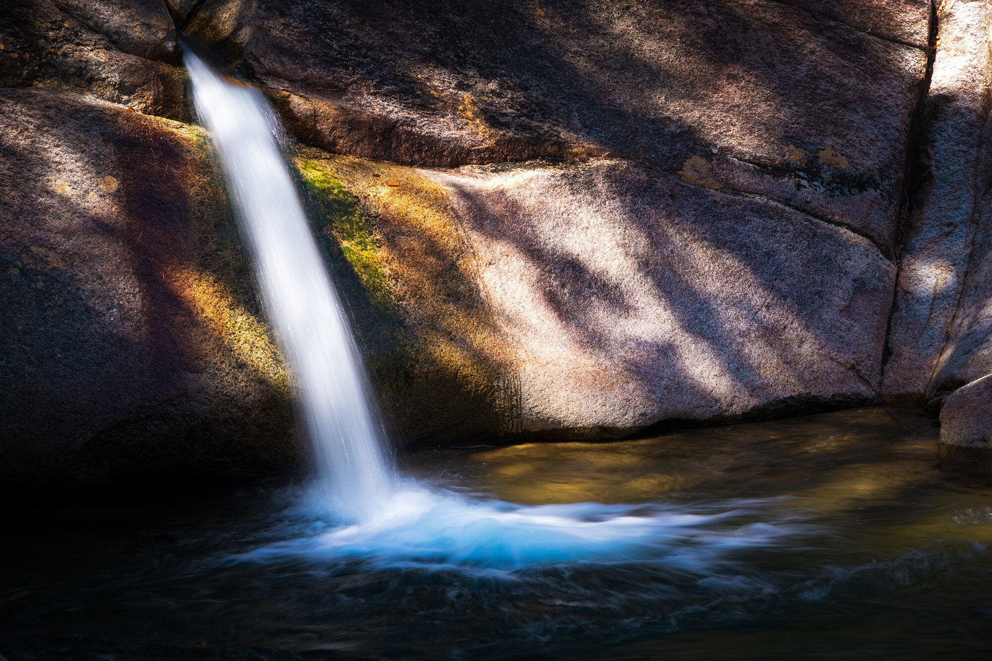
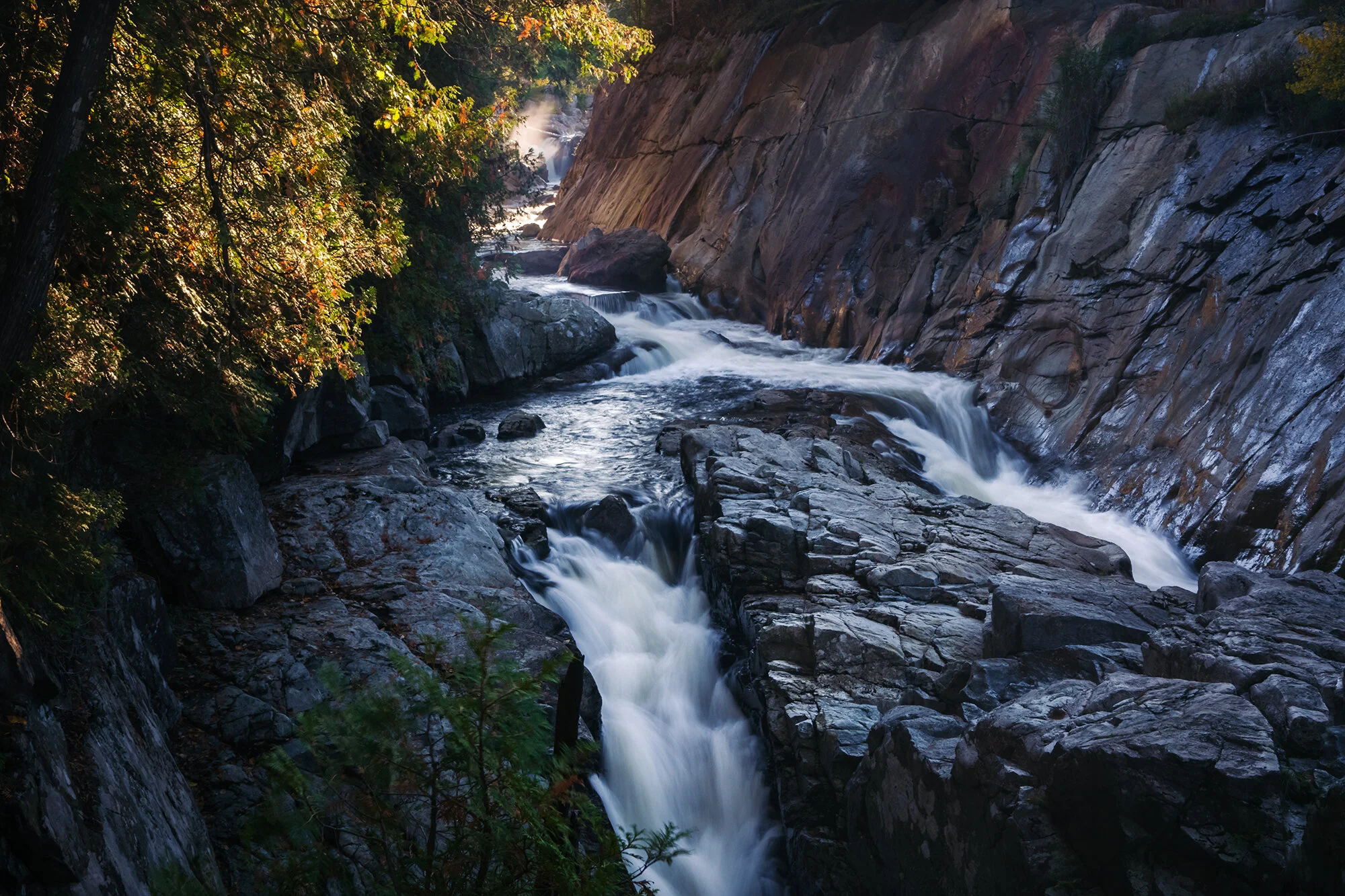
Heading south out of the Lamoille Valley, we turn onto VT-100, a famed driving route that cuts down the east flank of the Green Mountains. We stop to photograph Warren Falls and Moss Glen Falls, both looking beautiful against a cloak of golden foliage. Jane tries to ford the creek below Warren Falls against my advice; I have a good laugh a few moments later when she lands butt-first in the water just a few feet away from the creek bank. Further south, we have lunch at the Rochester Café and Country Store and browse the combined bookstore/café across the street, which has a wonderful collection of local memoirs and naturalist writing. Back on the road, we continue south, taking backroads to bypass Woodstock (another madhouse of foliage traffic). We spend a quiet afternoon and evening in a barn-converted-guesthouse on a farm in Reading, reading and watching movies into the night. The next morning (perhaps disillusioned by recent experience), we again choose again to ignore some of the area’s famously photographed farm scenes. We head homeward early, taking country roads overland into northern central Massachusetts and heading along Rt. 9 into Boston to avoid the pandemonium of this year’s unusually timed Boston Marathon.

New Hampshire: The Pemi Wilderness

Fall is nearly here, and from our base in Boston, it’s a fast two-hour drive to any number of beautiful places along the Atlantic Seaboard: the coast of Maine, the beaches of the Cape, the rolling hills and valleys of Western MA, and the mountainous uplands of Vermont and New Hampshire. Just over a month into our new work lives, Jane and I splurge on new backpacks and camping equipment, determined to make the most of our new surroundings. Comfortable as a clean bed and a hot shower might be at the end of a day’s travel, I’ve found car camping and hotel hopping to be severely limiting to my photographic craft, which is best done in the golden hours that bracket each day. I’ve long wanted to wake beneath the stars, miles deep within the wilderness, with pristine, picturesque landscapes a few feet outside of my tent. It’s not an experience that I’ve had any time recently in my adult life - at least not since I started photographing seriously. Until now, I haven’t had the time (or income) to make it happen.

With our new gear in tow, we set off on the second weekend of September for the northern tip of New Hampshire, to do an easy one-night camp in the Pemigewasset Wilderness (“The Pemi” for short), a massive woodland watershed that encompasses multiple ranges at the heart of the White Mountains. Setting off from Boston in the dark, we arrive at the quiet, between-seasons ski resort town of Lincoln around 7 AM, and find a parking spot up the road from the bustling trailhead parking lot shortly thereafter. Shouldering our packs for the first time, we walk several miles in along the rambling East Branch of the Pemigewasset River. Early fall colors are beginning to show here in the northern woods; along the forest canopy, the amber-red maples and golden birches are splashed among the leafy oaks and elms, and studded with pines and spruces. Morning light, that mystical, ethereal stuff of autumn magic, is filtering in through the fog and the trees. At the Franconia Brook campground, we find an empty tent platform and pitch our new tents. For relative newbies, we acquit ourselves fairly well, setting up our shelter and sleeping gear in about half an hour. After a brief snack break (nuts, bars, dried fruit), we empty our packs, stow our bear canister away in a tree hollow, and set off to explore. To reach the trails on the opposite bank, we cross the knee-high river barefoot; this winds up being a slippery, stony task that nearly ends with me face down in the water, and I vow to never again leave my water shoes behind in camp.

On the other side of the river, we walk along the Lincoln Woods Trail and climb the short path up to Franconia Falls - a series of slides where the river branch has carved its way through a slant of pink granite. Lying upon her pack, Jane takes a nap on the rocks, while I set up for long exposures of the nearby little cascades. We watch a family of school-age boys, happily tail-wagging black Labrador in tow, go plunging down the freshwater slides. In the mid-afternoon, we pack up and hike back across the river (this time I cross with my boots on, committing to their being wet the rest of the trip). Back in camp, I switch shoes and hang my boots against a tree to dry. We set up the camp boiler and heat two cups of water for our dehydrated dinners (a Mountain House breakfast skillet for me, and chicken and dumplings for Jane). In the evening, we briefly return to the riverbank to photograph the sunset light, before creeping into our sleeping bags for a long, chilly night in the forest.

Day 1: Ausable

“As a man tramps the woods to the lake, he knows he will find pines and lilies, blue herons and golden shiners, shadows on the rocks and the glint of light on the wavelets...
He can stand on a rock by the shore and be in a past he could not have known, in a future he will never see. He can be a part of time that was and time yet to come.”

- William Chapman White (1954)

What makes a landscape beautiful? What makes that beauty endure over time?

As a photographer and a lover of all things natural, I’ve grappled with these questions for many years, and I’ve written about them in the context of many places. There is something to be said for the concept of “unspoiled wilderness” - primeval land shaped over aeons by tectonic, hydraulic, and ecologic forces, but untouched by human hands. But these places are increasingly hard to find. Their beauty seemingly lies in their rarity, in the sense of adventure that comes with visitation, and in the painstaking, bittersweet acknowledgment that, in today’s globalized human civilization, such places will not remain wild forever without a significant fight. And even when nominally maintained as wild, sooner or later - through photography tours, tour buses, vacation resorts, and capital interests - it seems that each beautiful place will eventually bear the loving, smothering impact of human appreciation. Wilderness, the cynical environmentalist in me says, now exists only as a construct of certain “civilized” minds: a contrast to the modern city, and an ideal to be defended. But nothing more.

This definition of nature (one that emphasizes the wild and ignores the human) is one way to understand natural beauty. But it excludes many places in the world. It speaks against what I know empirically to be true - against the deep, emotional impact that I’ve felt from studying, visiting, and photographing, however briefly, places like the Hebrides, the Faroes, and Smith Island, where nature and humanity are hopelessly intertwined. Places like this present a different vision of nature - one that acknowledges the human presence. Where each landscape is imbued with human history and cultural meaning. These places have their own enduring beauty. The question becomes how long that beauty will endure after my brief visit (for after the photographer, comes the tour bus).

In the face of that question, the Adirondack Park in northern New York State offers a singular reply that forms the thesis of its existence: “Forever.” The park’s 6 million acres (nearly the size of Massachusetts, and larger than Yellowstone, Yosemite, Grand Canyon, Glacier, and Great Smokies National Parks combined) were enshrined in a 1894 amendment to the state constitution that declared New York’s forest preserve to be “forever wild”, reversible only by direct vote of the citizenry. Like many beautiful places, it is a place of contrast. It is the largest publicly protected area in the Lower 48 states, a land of 10,000 lakes, 30,000 miles of rivers, countless mountain peaks, and expansive wetlands and old-growth forests. It is also home to 100,000 year-round inhabitants in over a hundred towns and villages, and many more seasonal residencies, farms, businesses, and mining and timber interests. These form a patchwork of private land within the park that ebbs and flows with time and legal action, such that the Adirondack Park has been described (somewhat derisively) as “conservation in reverse” or (somewhat optimistically) as “the greatest experiment” ever undertaken in conservation.

For any who have studied conservation in the United States, the history of the park’s creation is striking for its unreliance on capitalist benefactors carving out land with wealth (as in the Tetons or Shenandoah), or on the presence of land whose expansiveness and remoteness favored early preservation over exploitation (as in Alaska and much of the interior West). To be sure, the Adirondacks are not without their ecologic and economic troubles. But, located just a few hours from New York City and the other great metropoles of the Atlantic seaboard, this mountainous land presents a uniquely hopeful and enduring vision for what natural beauty can look like in an increasingly human world. For what could be, if we strive to live in harmony with the land around us.

The Adirondacks are a mountainous massif bounded to the east by Lake Champlain and Vermont, to the west by the Finger Lakes region, to the south by the upland valleys adjoining the Hudson River, and to the north by Canada. It is host to an enormous range of ecosystems, including the largest forest preserve in the continental United States, the second-largest canoe area in the country (after the Boundary Waters), alpine and sub-alpine terrain at the heart of the High Peaks, and innumerable riparian, littoral, and edge communities wherever woods and waters meet. In short, it is a naturalist’s (and nature/landscape photographer’s) paradise. In fact, Jane and I had travel plans for the region (Lake George, specifically) as far back as Thanksgiving of 2013. This was back when we seemingly didn’t understand a thing about holiday traffic, driving distances, or late November weather in the North. We simply wanted to get out of the city, and pointed ourselves toward the largest concentration of freshwater bodies and mountain summits we could find. Fortunately, logic prevailed, and we stayed home that year, eventually taking our first vacation together in Shenandoah - the very first post on the Mid-Atlantic page of this site. As soon as I received my fellowship year schedule and saw a vacation slot in the first week of October, though, I knew that a return to the North, to explore the autumn Adirondack landscape by car, by foot, and by paddle and portage, was finally in order. This is how we spent the week of our 29th birthdays.

After an early morning flight with a layover in Philadelphia, we’re approaching Burlington, VT, in a small aircraft. From the airplane window, I watch as the rolling hills and farmlands of the Champlain Valley give way to the enormous body of water separating New York from Vermont, site of so much struggle from the days of empire (the French-Indian War) and before (the Algonquian and Iroquois Confederations). As we swing around to land in Burlington, I see the earth rising in a great wall beyond Lake Champlain - the Adirondack Mountains, weathered and imposing. Small wonder, then, that the interior of the massif was scarcely explored by Americans until well into the 19th century - at a time when the West was already being settled, the Colorado River’s canyons were being navigated by Powell, and Manifest Destiny had seemingly arrived. Before the mill towns and mining settlements, before the tuberculosis sanitoriums, the Great Camps, and the ski resorts, there were only the Native Americans, the fur traders, and a handful of hardy mountain men, guides and explorers whose deeds verged on mythic. The word “Adirondack” itself is derived from a Mohawk phrase meaning “bark-eater,” a derogatory reference to the hunter-gatherer Algonquins. Thus, although the park’s name today evokes scenic beauty, wilderness, and relaxed summers spent hiking and paddling, the English equivalent would be a futuristic alien civilization making a wilderness preserve of Earth and calling it “Motherfucker Planet”. History has a way of bringing such ironies into sharp focus.

In Burlington, we quickly pick up our rental car, a white Toyota Camry. After a pit stop at the local Hannaford grocery store (chocolate croissants, fruit, and milk for breakfast; instant noodles and a variety of canned proteins and vegetables for lunch and dinner), we head south to the Charlotte-Essex ferry, which takes us across Lake Champlain and to the foot of the Adirondack Mountains. Along the way, we pass apple orchards, dairy farms with pastured cows, and fields of baled hay. Outside of Keene, we stop at a meadow to admire the colors in the trees. Autumn comes much more quickly in the North than in Maryland - and whereas we in the Mid-Atlantic have just begun detect a whiff of the great seasonal change, here the birch and beech trees stand like golden amber on the hillsides, and the Main Street of every little town we pass through has a maple tree aflame with bright crimson leaves. We have arrived just in time for the region’s peak autumn foliage, which spreads from late September to early October, outward like a wave from the High Peaks region to the surrounding foothills and valleys, and southward from the park’s northern boreal ponds and forests to the lowland waterways and woodlands. In about an hour of pleasant driving, we make our way from the shores of Lake Champlain to the town of Lake Placid just below the High Peaks - our home base for the coming week.

At Lake Placid, we check into our accommodations - a cozy ground-floor apartment with a full kitchen, a living room, and a roaring fireplace. After unloading luggage and groceries, we have a quick snack break before heading out for the afternoon. We take Route 86 northeast out of town and through the pass below Whiteface Mountain, following the West Branch of the Ausable (Au Sable: “Sandy”) River as it emerges from its source in the High Peaks and drains toward its delta on the western shore of Lake Champlain. Along the way, we pass High Falls Gorge, where the river drops out of the upland forest in a series of steep, picturesque waterfalls. We stop at several points to photograph the river and its surrounding foliage. Parking roadside at Monument Falls, we descend the dirt bank of the river to watch it curve into a lovely, shadowed stand of pine and spruce trees. There is a another excellent composition here - of the river and road curving together to the northeast as the summit of Whiteface soars behind them; but the harsh mid-day light, even with a ND filter, blots out all features on the river and turns the roadside foliage a ghastly, jaundiced color.

Next, we stop at the parking area for Whiteface ski lifts, where a bridge over the river affords a lovely view of the rocky riverbank. The ski area is swarmed with tourists heading up Whiteface for afternoon summit views; we choose to steer clear. Moving on, we stop on either side of the Wilmington Flume, a chute of turbulent falls just a mile below High Falls Gorge. On the northern side of the Flume, a roadside parking area and a neat dirt trail lead to a pond with a flooded forest, standing beneath the eastern aspect of Whiteface Mountain. Jane and I take photos together here; the path continues and allows access to the river for the fly-fishermen, whom we watch from above.

Crossing the road bridge to the southern side of the river, another dirt trail descends steeply beneath the level of the road and through a stand of fir and pine trees. The ground is covered by a thick, soft mat of pine needles and fallen leaves, and the roar from the cataract below us is deafening. A few minutes down this path, we find a wide ledge just above the main section of the Flume, buttressed by the roots of a solitary oak tree. Jane walks out while I photograph the swirling spray of the falls, illuminated by the glow of afternoon sunlight. For the sake of time, we choose not to descend further along the river, but there are undoubtedly other fascinating waterfall compositions to be had in this area.

Back on the road, we pass through Wilmington as the sun sinks toward the hulking wall of Whiteface Mountain. In town, we stop on the bridge beside the town’s tiny public library. Here, the West Branch of the Ausable emerges from the mountains, becoming a slow, broad river surrounded by marsh grass and mixed hardwood stands. The river’s curve looks particularly lovely in the light of the setting sun, against the backdrop of the Sentinel Range. A few miles east of town, we stop at our sunset destination and terminus for the day - an expansive meadow that opens up to an amphitheatre of mountains. Clements Mountain sits to the immediate southeast, with the Jay Mountain Wilderness beyond, while the Sentinel Range and Whiteface lie to the southwest and west. I take a timelapse of sunlight fading on the distant, forested slopes, before we make the short drive back to Lake Placid and the first of many extravagant noodle dinners on this trip.