Day 6: The Great Glen

The snow comes down hard through the night. I set an alarm for 5 AM to peek outside and, seeing the hotel's back lot stuffed with snow, I re-set the alarm for 8 AM. Our original itinerary called for an 8-mile hike from Morvich to the magnificent Falls of Glomach deep in the central highlands.  For a second trip in a row (after Iceland's Glymur hike), our Waterfall of the Trip has been scuttled by unusually wintry conditions. We sleep in and enjoy a sit-down breakfast in the hotel's lobby restaurant before setting off from Kyleakin around 9 AM with plans for two alternative hikes and a shorter day overall. We proceed east from Kyle of Lochalsh through Kintail, stopping briefly beside Eilean Donan Castle on the shores of Loch Duich. The snow-covered pine forests near the Kyle soon give way to a brilliantly clear morning as we pass Shiel Bridge and rejoin our inbound route from Fort William. After several days of relatively mild weather, we are destined to see some quantity of snow every day for the rest of the trip - though, quite mysteriously, it never accumulates.

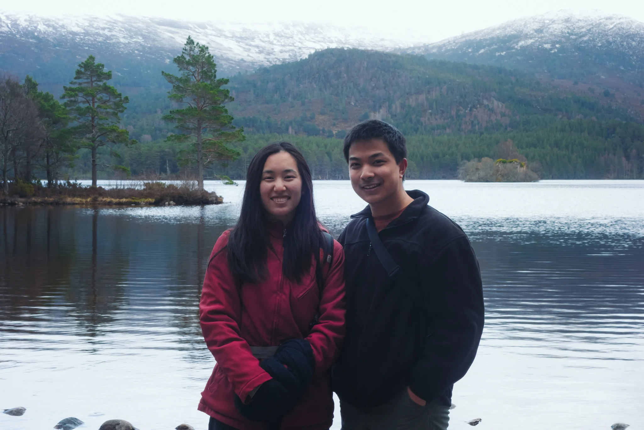
Heading northwest from Kintail toward Loch Ness, we stop first at the Dundreggan Conservation Estate, a rare plot of ancient Caledonian woodland administered by Trees for Life and the Scottish National Trust.  Leaving a donation at the car park, we take a brief walk up the hillside into a grove of gnarled, thousand-year-old pine woods. In a sunny clearing among the trees and the dense, brown curls of bracken, we get a nice view of the River Moriston below us. Dramatic vistas and sweeping landscapes having come and gone without any good opportunity to do so, I finally propose to Jane here, in a quiet, ancient little forest just off the highway. She runs to turn off my camera before saying yes.

We drive next past the village of Invermoriston, bearing left on the A82, which cuts from Fort William in the southwest to Inverness in the northeast, following the great slip fault that transects Scotland, dividing its Northern Highlands from the Grampian Mountains. This fault, over time, was dug into a shallow valley by glacial ice and eventually filled by wood and lake water. That lake is now known as the famous Loch Ness, and the bed it inhabits is known as Glen More or Glen Albyn ("The Great Glen", "The Glen of Scotland"). Cruising north along the highway as it curves along the west shore of Loch Ness, we pass through the town of Drumnadrochit and bypass the famous Urquhart Castle. We stop at the Clansman Hotel near Abriachan. Jane goes into the gift shop to buy a pack of hard mint candies before we set off north of the car park, following an old coffin road up the hillside overlooking Loch Ness. After a mile of constant, steady climbing, we reach a lookout point around a switchback, and are rewarded with a single wooden bench to sit upon and enjoy a sweeping view of the lake. From here, we can see the city of Inverness to the north, and to the east of us across the lake, the smooth ascent of the glen into a broad, high plateau - the Monadliath Mountains and, beyond them, the Cairngorms. We are bound for the ski town of Aviemore, nestled in a valley within that snowy plateau.

After sitting for awhile and taking in the views, we descend the coffin road and return to our car at the Clansman Hotel. We eat a quick lunch in the backseat before continuing our northward drive, into Inverness. In the city, we find another Morrison's and re-supply our stock of sandwiches, fruit, drinks, and pastries. Jane assumes the steering wheel for her third and final time of the trip as we leave the city and navigate southeast, ascending the broad plateau into the Grampian Mountains. Farmland and riverland quickly transform into snowy hills covered in conifers, cliffsides, and jagged mountaintops. The two-lane highway is gently sloped but constantly winding. Jane plants us firmly behind a Fedex tractor trailer ("FedEx lorry! FedEx lorry!" she corrects me) and becomes its best friend -  no one can spite us for driving slowly if our front bumper is glued to an 18-wheeler. In spite of this, we make good time, and leave the highway around 3 PM to arrive at the adorable Rowan Tree Country Inn, a 3-story cottage with a snow-covered yard and a roaring fireplace. After carrying our bags to our very pink room on the top floor, Jane takes an afternoon nap while I perch by the window, watching the snow fall over the fir trees as cars come down the road one-by-one, their headlights glowing. In the evening, we head downstairs for a delightful dinner of lamb and fish.  Jane stays up watching B-rate horror movies.

Day 7: The Cairngorms

We are up bright and early the next morning. In the dining room, we help ourselves to coffee, tea, fruit, and toast; Jane picks the full option (above), while I ask for an omelette with local smoked salmon. I go outside to scrape the ice off of our windshield while the kitchen prepares our food. After breakfast, we drive a few minutes north to Aviemore ("Big Dwelling Place"), a ski town with wooden storefronts advertising outdoor sporting apparel, horseback rides, and mountaineering tours. We park at the local hostel and follow a path behind its log cabins. There, passing under the highway, we join the trail into Craigellachie ("Crag of the Rocky Place") Nature Reserve, an acreage of silver birch trees and small lochans on the eastern flank of the Monadliath Mountains. We follow the path through the trees and around forest ponds, gaining elevation as we climb westward toward a hilly ridge. The view back toward Aviemore opens up - little shops, streets, and one incongruously large hotel tower - against the backdrop of a distant, snowy plateau. At the top of the trail, we find a snow-covered meadow tucked into a shady glen between two mountains. We turn south here and climb a series of stone steps that lead us up through the snow, to the top of the range - more of a broad, elevated moorland than a distinct peak. The path, surprisingly accessible and clear despite the abundance of snow, leads us to a summit cairn with marvelous views to Loch Dubh and the Speyside valley to our south, and Aviemore, the Rothiemurchus forest, and the Cairngorm massif to our east. After taking in the view, we retrace our steps down to the birchwood and back to our car.

After a brief pit stop on the main street in Aviemore (Jane buys extra socks and a wool sweater at the mountainwear shop), we head east through the forest and up the winding road to the ski area on Cairn Gorm. The parking lot is near capacity, and the chairlifts up the slope are bustling with visitors. We sit in the cafe and check our maps before heading south on a snow-covered path away from the ski area. Skirting around the last chairlift and over a stream of snowmelt, we pass around the contour of the slope and are suddenly alone in the vast, barren whiteness of a granite mountain plateau. The wind howls down the mountains around us, and the clouds move swiftly overhead.

One of my favorite works of nature writing is The Living Mountain, a gorgeous narrative of these mountains by the Scottish novelist and poet Nan Shepherd, who spent eight decades of her life living in and exploring the Cairngorms. In planning our itinerary, and again while driving up the mountain, I wondered whether my experience of this place would be cheapened by the the vehicular road, the abundance of skiers, the effortless access to a truly special place. How much have these mountains changed since Shepherd's days climbing them and sleeping under the stars? Or perhaps - how little? As I gaze across the plateau on our walk toward Coire an t-Sneachda (appropriately, "Corrie of the Snow"), at the endless icy expanse cut by the cleft of the Lairig Ghru, it is easy to see that much of what Shepherd lovingly described is still well and very alive:

"The plateau itself is not spectacular. It is bare and very stony, and since there is nothing higher than itself nearer than Norway, it is savaged by the wind. Snow covers it for half the year and, sometimes, for as long as a month at a time, it is in cloud. Its growth is moss and lichen and sedge, and in June the clumps of Silence - moss campion - flower in brilliant pink. Dotterel and ptarmigan nest upon it, and springs ooze from its rock. By continental measurement its height is nothing much - around 4000 feet - but for an island it is well enough, and if the winds have unhindered range, so has the eye. It is island weather too, with no continent to steady it, and the place has as many aspects as there are gradations in the light...

This bodily lightness, then, in the rarefied air, combines with the liberation of space to give mountain feyness to those who are susceptible to such a malady. For it is a malady, subverting the will and superseding the judgment: but a malady of which the afflicted will never ask to be cured. For this nonsense of physiology does not really explain it at all. What! am I such a slave that unless my flesh feels buoyant I cannot be free? No, there is more in the lust for a mountain top than a perfect physiological adjustment. What more there is lies within the mountain. Something moves between me and it. Place and a mind may interpenetrate till the nature of both is altered. I cannot tell what this movement is except by recounting it..."

- Anna "Nan" Shepherd (1945)

Two hours later, as we leave the ski area, a herd of reindeer clambers up from the downhill side of the road.   Fifteen or so lovely, furry beasts (and one baby) walk out right in front of our car and stop, grazing at plant life that must plainly be invisible to the rest of us. We sit and watch for a few minutes (the oncoming traffic is stopped as well); Jane takes photos as I deliberate how to get around them.  In a fit of inspiration, I roll down the window and, hollering like a prairie rider and waving my hands in an imaginary lasso, I drive the herd forward using the front of our car. The overall effect (me yelling, swinging, and pushing large mammals forward at 5 miles per hour) is hilarious to Jane, who cannot stop laughing in the back seat. I can only imagine what the drivers behind me were thinking. Eventually, we break free and proceed down the mountain. Only weeks later, through a cursory note in a brochure, do I realize that I have driven the only herd of reindeer in the entire United Kingdom using a Mercedes Benz -  an accomplishment worth celebrating.

We head to our last stop of the day - Loch an Eilein, a lovely wooded lake nestled deep within the Rothiemurchus Forest. At the trailhead, we pay a small fee toward the trust that maintains these woodlands for walking and recreation, and we set off clockwise on the 4-mile path circling the lake shore. We pass first through stands of young pine trees, a familiar sight for sore Maryland eyes. As we swing to the south side of the lake and up the west shore, the trees grow taller, thicker, more gnarled and deformed - ancient Caledonian beasts, standing proudly apart from one another, hundreds of years old. Somewhere on the south shore of the lake, near a massive oak tree, I drop my tripod adapter in the dirt while fumbling with my equipment; we do not notice until more than a mile later, when I attempt to set up for a long exposure of the ruined castle at the center of the lake. I am more than a bit upset at myself as I retrace my steps, Jane patiently accompanying me; fortunately, she spots the small piece of black plastic by the side of the path. We wind up walking a total of 6 miles around the lake shore, adding to our unexpectedly tough total of nearly 12 miles on the day.  We return to our room at the country inn to shower, relax, and eat dinner. As night begins to fall, petals of snow are drifting down onto the pine trees outside our window.

Day 8: Perthshire

The next morning, we pack our bags and head downstairs. Again, I go outside to scrape the snow and ice off our car before sitting down to a full platter of eggs, bacon, sausage, beans, and grilled mushrooms and tomatoes. After breakfast, we stop by the Rothiemurchus visitor center where we pick up a tuxedo cat oven mitt and a free postcard. An icy mix is coming down as we rejoin the A9 and head out of the Cairngorms, windshield defroster at full blast. The highway follows the valley of the River Spey southward before curving east to follow the River Garry. We soon leave the Grampian Mountains - and the Scottish Highlands - behind. The snow disappears as we descend into the rolling, rich farmlands of Perthshire.

Near Dunkeld, we turn off the highway and drive east through the countryside to Blairgowrie, a quiet agricultural town of just over 8000 people. In the suburbs, I park the car on a residential street off of Perth Road, and we cross the street and head into the Ardblair Woods. This place is a world apart from the snowy highland plateaus of the Cairngorms, or the windswept island moors of Skye. The grass is beautifully lush and green, and the path winds in and out of the woods, taking us through newly plowed berry fields and behind vast yards of pastureland. Crossing west through the farmland, we arrive at a circular hill covered in trees, looking very much like a magical woodland grove from a Miyazaki film. We open a farm gate and enter the woods. I am disappointed to find that the forest's carpet of Scottish bluebells (Campanula rotundifolia) has not still not bloomed; alas, we are only one week too early. Still, the bluebell woods are quietly beautiful. We kneel down in the grass and see little purplish flowers coming up through the leaves and bracken. Walking a lap around the grove, we twice pass by the same woman walking her retriever. "Hello again!" she says cheerily to us, in an accent distinctly less Scottish than what we grew accustomed to further north.

Leaving the woods, we head south on another grass path through tilled fields, toward a farm building in the distance.  As we pass the farm and complete our 2-mile loop along a pond (White Loch), a grey curtain of rain clouds sweeps toward us from the north, arriving in a sudden downpour. We don our Kennedy Space Center ponchos - finally of use for the first time since Iceland - and run back to Perth Road and across the highway. In our car, we head north to Blairgowrie proper, stopping at the local Tesco for the final grocery re-supply of the trip.  After a backseat lunch of soup, pasta salad, clementines, and cheese danishes, we begin an afternoon drive through Perthshire toward our last destination - the capital city of Edinburgh.

We follow the A93 southward along the River Tay, awkwardly detouring to Scone Palace (a historic late Georgian house and grounds) before we realize the stiff per-person admission fee. Shamelessly, we turn the car around and drive back out to the highway. We continue through the city of Perth, eventually merging with the M90 to head south toward Edinburgh. Traffic builds as we pass over the Forth Road Bridge - one of two, soon to be three, adjacent bridges arching high over the Firth of Forth. ("I AM CROSSING THE FIRTH OF FORTH FROM THE KINGDOM OF FIFE," I announce to Jane in a half-scream). We navigate east toward the capital, passing through the city center with its attendant Friday afternoon traffic and winding cobblestone streets.

Just north of the Waverly train station and on the edge of Edinburgh's New Town, we leave our car in the parking structure of the St. James Place shopping mall, and carry our bags down several flights of stairs to the city street. We check into our room for the next two nights at 27 York Place, a brownstone townhouse converted into a bed-and-breakfast. Edinburgh, for obvious reasons, was the hardest place for me to find affordable accommodations during the planning phase of the trip, but the room is surprisingly spacious and the furnishings comfortable. We take a brief break before heading out around 5 PM for our final hike of the trip -  a climb to the top of Arthur's Seat to look over the capital city at sunset.

We walk along Princes Street and then Regent Road, passing under the monuments on Calton Hill - proud spires flanking what looks very much like a half-built Parthenon, a tribute to Scottish lives lost during the Napoleonic Wars. Descending a steep flight of stone stairs, we pass through a cemetery and emerge onto Calton Road. We skirt the Scottish Parliament Building and Holyrood Palace to reach the trailhead at the foot of the Salisbury Crags, a palisade of basalt cliffs left untouched by a glacier that swept through this range two million years ago.  There is a procession of hikers climbing the steep path along the crags - brightly colored specks on the against the igneous rock - but we opt to follow the trail of the glacier. We head north for a few hundred yards before turning east, walking up a ridge along the rim of an extinct volcanic caldera, its slopes overgrown with grass and brilliant, golden gorse. At the top of the caldera, we begin a final rocky climb to the top of Arthur's Seat. From the summit, there are panoramic views in all directions: the entire city of Edinburgh to the west, the Firth of Forth to the north and east, and the rolling lowlands and the snow-topped Pentland Hills to the south. A police helicopter, flying routes over the city, buzzes nervously close to us on the mountaintop before disappearing. We watch the sun drop toward the horizon before descending the volcano and returning to the city and grabbing dinner at a Chinese noodle bar on Princes Street.