Day 6: Signal Mountain

The next day starts with sunrise on the north shore of Yellowstone Lake.  With Jane sleeping in, I take the car a mile west of the cabin and park roadside on an open stretch of shoreline with an eastward view. In the darkness, I set up my tripod and wait in the chilly lakeside air. The deep blue of the morning begins to lighten gradually. There is a low cloud cover that blots out most of the sky, and the distant Absarokas that I hoped to catch in timelapse are, unfortunately, mostly shrouded. But as the dawn comes over the range, waves of sunbeams begin to stream through the dissipating clouds, covering the shimmering glass of the lake surface with patterns of pastel pink, purple, and blue. One last, gorgeous sunrise beside Yellowstone Lake, and well worth the early morning.

Back at the cabin, Jane is just waking up. We collect our things (our once formidable food stores depleted to just a few juice bottles, trail mix, and the nasty huckleberry twists), load the car, and check out in the hotel's main lobby. We drive west around the north shore of the lake for the final time, heading south at the West Thumb road junction.  At West Thumb, a semicircular blast crater formed in an eruption of the caldera 70,000 years ago, the lake flows into a bay whose edges are lined with geysers and hot springs. We walk the boardwalk around the geyser basin, filled with geothermal features like the Fishing Cone, a tiny geyser where fishermen would catch and boil their trout on the spot through the park's early years. In the morning fog, the basin is quite eerie, its startling blue hot springs seeming to stretch into infinity, while the water beside the shore terminates in a white curtain where one knows there ought to be an entire lake with distant horizons of pine forest. Near the car park, we run into a female elk grazing beside the boardwalk. She walks within a few feet of us before ambling off to the other side of the basin. We also see a snowshoe hare munching on grass in its summer outfit - a brown overcoat with comically oversized white boots.

A mile south, we make a stop at Grant Village, a collection of dormitories, cabins, and general stores hugging the shore of West Thumb. The general store has an impressive cafeteria by Yellowstone standards (hot food!), where the two of us chow down on buttermilk pancakes, scrambled eggs, and bacon.  I go for another cup of fudge and peach ice cream (my last ice cream of the trip, I swear). Then we are southbound again, climbing over the lower edge of the caldera and past Lewis Lake. We leave Yellowstone at its southern entrance, where an impressive line of Memorial Day weekend traffic is waiting in the opposite direction.

We continue along the John D. Rockefeller Highway, named for the man whose land purchases in the early 20th century eventually led to the creation of Grand Teton National Park as we know it today. As we leave the mountainous Yellowstone plateau, the road descends sharply into Jackson Hole, a sunken valley between the Tetons to the west and the Gros Ventre Range to the east. Rounding the north end of Jackson Lake, the road turns ever so slightly to parallel the lake, and across the water, our sightline is cut by a massive wall of marine rocks crowned by a parapet of serrated peaks and hanging glaciers. One of the newest mountain ranges in North America, the Tetons rise abruptly, soaring 7000 feet up  from the valley floor with no intervening foothills or graduated slopes. This incredible relief is an artifact of tectonic uplift along the western side of the Teton Fault (upon which the mountains sit) and corresponding depression along the eastern edge (creating Jackson Hole), as well as the young age of the mountains - too young to have been significantly sculpted and weathered by wind and water,  like our gentle Appalachian range back home.  The result is a signature mountain landscape that is as picturesque as any in the world - the purple mountain majesties of "America the Beautiful".

We stop at the Jackson Lake Lodge  for a short climb up Lunch Tree Hill, a little rounded knoll behind the lodge that looks over willow flats, creek beds, Jackson Lake and Elk Island in the distance, and beyond them, the towering Cathedral Group at the heart of the Tetons. We walk back through the sagebrush and the cabin grounds beside the lodge, then spend some time browsing the hotel gift store and admiring its tall glass lobby windows facing to the west. Back in the car, we proceed south over the Snake River and to the southern shore of Jackson Lake; it is still too early to check into our lodgings at the Signal Mountain Lodge, so we continue a mile west to its namesake, a 1000-foot, pine-forested mound of glacial moraine and volcanic ash (from a Yellowstone super-eruption in distant geologic history). Conveniently, there is a vehicular access road that we ride to the west-facing secondary summit, and the east-facing main summit. To the east, there is a lovely expanse of green valleys and rivers curving toward the comparatively tame Gros Ventre and Wind River mountains of central Wyoming. To the west,  even from a thousand feet above the valley, the spires of the Cathedral Group, punctuated by the massive spear-point of the Grand Teton itself, all but loom over us from ten miles' distance. We head back in the early afternoon and spend some time familiarizing ourselves with the amenities at the Signal Mountain Lodge - a gas station, convenience store, gift shop (where we purchase two on-sale fishing hats for future hikes), two restaurants, a marina with boat rentals, and finally, our cabin behind the lodge, a rustic (ugh) little log affair with a hotel room's heart of gold.

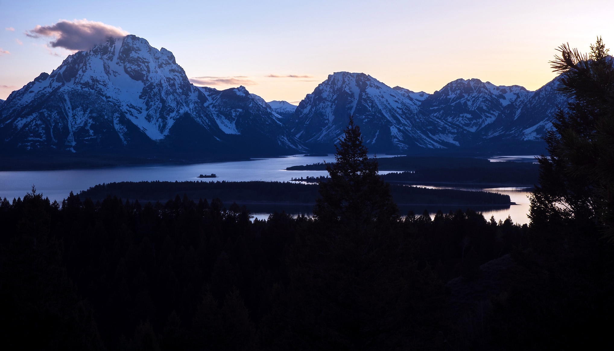
In the evening, after dinner at the Trappers Grill (onion rings, cheeseburger, and cornbread with chili; I resist the huckleberry crème brûlée being paraded across the dessert menu), we return to the top of Signal Mountain to watch the sun set over the Tetons. In a clearing on the side of the mountain, the atmosphere is nearly festive as we are joined by several hikers and other photographers. We trade selfies with a few other travelers, after which I find a small spot in the dirt to set up my tripod and aim it through the trees. It takes awhile for me to pick a composition, but I settle on a timelapse of Jackson Lake (rendered a winding waterway by the pine forests on Donoho Point and Elk Island) in the foreground, and lenticular clouds dancing over Mt. Moran in the background. With the second camera, I walk around the clearing, mostly shooting toward Teewinot and the Grand Teton, as purple and golden sunbeams glint off their snow-covered flanks. In the distance, a dark oval glides across the water near Marie Island, bound for the shores of Hermitage Point; we assume it is a kayak or canoe until we notice a set of antlers skimming above the surface. Then the sun sinks behind the mountain, and a shadow falls over the lake and woodlands.  As we make our way down the mountain and back to the cabin on the shore, the distant snowfields and glaciers are glowing against the darkening sky, like nightlights mounted on the wall of a childhood bedroom.

Days 7 & 8: Tetons

We're up early the next morning for a counterclockwise spin around the park, first heading east from Signal Mountain to Oxbow Bend, where the slow-rolling Snake River, flowing out of Jackson Lake, makes a horseshoe-shaped meander.  There is a full contingent of photographers here, eager to catch the colors of sunrise on Mt. Moran directly to our west. We set up on the riverbank and watch the morning sky slowly becomes lighter, and the morning fog lifts over the valley floor. The day is shaping up to be brilliant and cloudless - not as great for landscapes, but excellent for hiking and exploring. Next, the highway follows the course of the Snake River. We drive southwest past elk flats and dude ranchers, the line of triangular peaks always hovering reliably to the west. At the Snake River Overlook, where Ansel Adams captured his famous portrait of the Grand Teton, we see an impressive series of fluvial terraces, created by a formerly larger river in days of ice and floor. The pine forest below our perch has grown up and over the river since Adams' day,  and it is no longer easy to capture the iconic bend of the river in the foreground without an aerial drone - for the better, I suppose.

Our next stop takes us off the highway and down a short dirt road to Schwabacher's Landing,  a sleepy little side-stream of the river lined by beaver dams and  rocky shallows. The groves of cottonwood along the riverbank provide some shelter from the valley's winds, and a reflection of the Cathedral Group shimmers off of the calm, glassy water. Back on the highway, we take a detour along Antelope Flats Road to Mormon Row, where a group of old homesteads, long abandoned, sit on the plain beneath the mountains. We take some photos goofing off with the the gophers near the Moulton Barn, another iconic  subject whose pointed tin roof imitates the peaks of the imperial range it stands under.  After this, we return to the highway and turn down Teton Park Road to enter Grand Tetons National Park proper.  It is too early on Saturday to catch brunch at Dornan's Chuckwagon, so we head to the main visitor center up the road, where we eat sandwiches and fruit from our dwindling supply in the parking lot.  The visitor center is a surprising Japanese affair, with slanted awnings overlooking a Zen rock garden, and a wood-and-glass paneled back wall that opens onto the mountains in its backyard. From the park gift shop, I purchase a fridge magnet and Fritioff Fryxell's classic manuscript, The Tetons: Interpretations of a Mountain Landscape, to add to our book collection. Up the road, we stop at the Chapel of the Transfiguration, a quiet little log chapel whose altar window looks upon the slopes of the Grand Teton. We sit for a few minutes on the wooden pews, enjoying the solitude, before heading north to our two hikes for the day.

Our first hike, the Taggart Lake Trail, climbs 2 miles from the valley floor, through pine forest, to a glacial chain lake at the foot of the Cathedral Group. We begin on the banks of Cottonwood Creek, a burbling, trout-filled stream that runs parallel to the mountain range and, in spite of its dimunitive appearance, is the main artery that funnels the eastern half of the Tetons' watershed toward the Snake River. After passing through a grassy meadow, we enter a mixed forest of lodgepoles and spruce trees. The trail crosses a wooden footbridge over Taggart Creek before climbing parallel to the cascades; the sky opens up to the awe-inspiring sight of the Middle Teton and Grand Teton, looming over us to the west as we walk through boulder fields, groves of silvery, delicate aspen, and stands of new-growth conifers. Heading left at the junction with the Bradley Lake Trail, we scramble over fallen logs to bypass a flooded, muddy section of trail, coming after half a mile to the southeastern shore of Taggart Lake. The air in this pocket of forest is windless and calm, and the views toward Avalanche Canyon and the mountains above are reflected on the sub-alpine lake's glassy clear surface.  We pose for photos atop a boulder on the water's edge before returning back down the trail to the road.

We continue north, stopping at the Jenny Lake Visitor Center to inquire after trail conditions in Cascade Canyon, which we had planned to hike tomorrow.  At this point, we are unsurprised by the dismal news: the initial climb from the west shore of the lake into the canyon will require crampons, forcing us to arrange for something less icy and strenuous (i.e. sleeping in, among other things) on the last day of our honeymoon. A few miles up the road, we turn into the junction toward String Lake and park on the shoulder of the road for our second hike: an unmarked walk through brush to the Old Patriarch, a majestic, 1100-year-old limber pine that stands near the ruined bed of the old park road and has been long forgotten by most park visitors. Jane and I cross the park road, descend into a stand of pines, and emerge onto a flat plain of sagebrush that stretches as far as the eye can see. Using the compass and GPS headings on Jane's phone, we shoot for a distant grove of trees and set off, weaving and winding our way through the thigh-high brush. The road and the sound of traffic recede into the distance behind us, until we are left with just a roof of azure sky, a western wall of towering, snowy mountains, and big, open views in every other direction. Jane and I cut our own paths through the sage, slowly picking our way over half a mile. We descend two sloped benches on the valley floor (water lines in ancient times of glacial flooding) before we see, in the distance, the unmistakeably lopsided crown of the Old Patriarch, standing alone at its perch beneath the mountains. I walk up to the old tree to touch its bark and examine its distinctively patterned trunk, which was revealed when the northeastern half of the tree split off decades over. The result is a remarkably photogenic tree when shot from the east, with its crown of pines, its long limbs askew, the Cathedral Group as a backdrop, and a stand of nearby pines to balance the composition. Jane and I take portraits together with the tree before climbing back up the terrace and returning through the sagebrush to our waiting car.

Back on the road, we continue north and then east to complete the Teton Park loop, winding up back at Signal Mountain. We return to our cabin for a mid-afternoon nap before waking up to forage for food; feeling quite sore of sandwiches, we wind up sharing a platter of fish and chips with vegetable soup at the Trappers Grill. As we eat dinner, a dark hammerhead appears over the peaks to our west before rushing down the mountainside; it is quite terrifying to see the sky-high summits covered by this even taller, larger cloud.  We walk out to the marina to see the storm blow in: furious winds whip across Jackson Lake as the curtain descends over the mountains, and the fishing cruisers and pontoons bounce up and down the waves. Hail begins to fall. Needless to say, our plans for kayaking around the lake at sunset are scuttled. We retreat to the cabin and enjoy a quiet evening indoors as we wait out the storm.

The next day, our last day in the Tetons, the skies are blue and featureless, and the morning is calm and clear. I am feeling under the weather and Jane is all hiked out, so we resolve to take things easy. We eat a mid-morning breakfast at the Trappers Grill (a Southwestern omelette for me and a platter of pancakes for Jane) before renting a two-person kayak at the marina and heading out onto the lake.  For about an hour, we paddle around Jackson Lake, struggling to maintain a straight course (the problem, we discover, is me). Zigging and zagging, we cross the water to Donoho Point, with its sandy beaches and tree-lined slopes. The chain of mountains, with their snow-capped peaks, serve as an impressive backdrop to our morning on the lake.

In the afternoon, I settle down to organize photos and pack, while Jane takes the car for a spin; she winds up heading back to the Jackson Lake Lodge and reading from Fryxell's book under in its massive glass lobby.  After dinner, we return to the western park road to catch our final sunset of the trip, at a roadside turnoff looking into Cascade Canyon. Jane walks around framing shots with the backup camera while I set up my tripod for a timelapse of the canyon. We watch as the sun dips over the mountain wall to our west; across the east, the triangular shadows of the peaks lengthen and expand over the valley floor.  The sun rays  gradually diminish until there is only light coming through the canyon itself, painting the northern flank of Teewinot with gold, then purple, then deep red light.  The jagged, icy ridges of the mountain are the last to be lit in the fading alpenglow - then all is dark.  We drive back to the cabin, our high beams cutting through the dark sage plain.

Early the next morning, we drop off our keys at the main lodge before taking the same road south, past the mountains and their glaciers still glowing, transluminescent in the dark. The airport in Jackson Lodge, Wyoming, is just few minutes south of the park, sprawled across the valley floor behind the hillock of Blacktail Butte. In the dawn light, we unload the car and return our keys in the little airport terminal.  While waiting for our flight, I browse a free book deposit in the airport while Jane peruses a gallery of wildlife photography on its walls.  From there, we are bound for Utah and then back home to Baltimore, where we finish our trip in the late afternoon.

 Yellowstone and the Tetons,  with their magnificent western landscapes and their geologic and ecologic wonders, were truly an unforgettable place to spend our first week of married life. They were also a place unlike any other that we've been - not like Iceland with its primeval vastness, or Scotland with its storied hillsides of swept heather. The Greater Yellowstone, with its millions of acres of protected ecosystem, represents for me a vision of the West - as something raw, limitless, and untamed. Yet how much of the West is truly untamed? For most park visitors who, like Jane and I, rarely strayed off the beaten path, was it wilderness we were seeking, or just a series of attractions in the name of wilderness? For the ranchers offering horseback tours into the backcountry, are these mountain slopes a way of life, an obstacle to be surmounted, or a resource to be exploited?  Is nature a place to be photographed, a sanctuary to be preserved, or something bigger entirely?  Again, there are no answers - only a ongoing dialogue between us, and the place where we live.

Landscapes from our first week of married life.
 
Music:
"Wind Scene" - Yasunori Mitsuda