Day 4: Mammoth

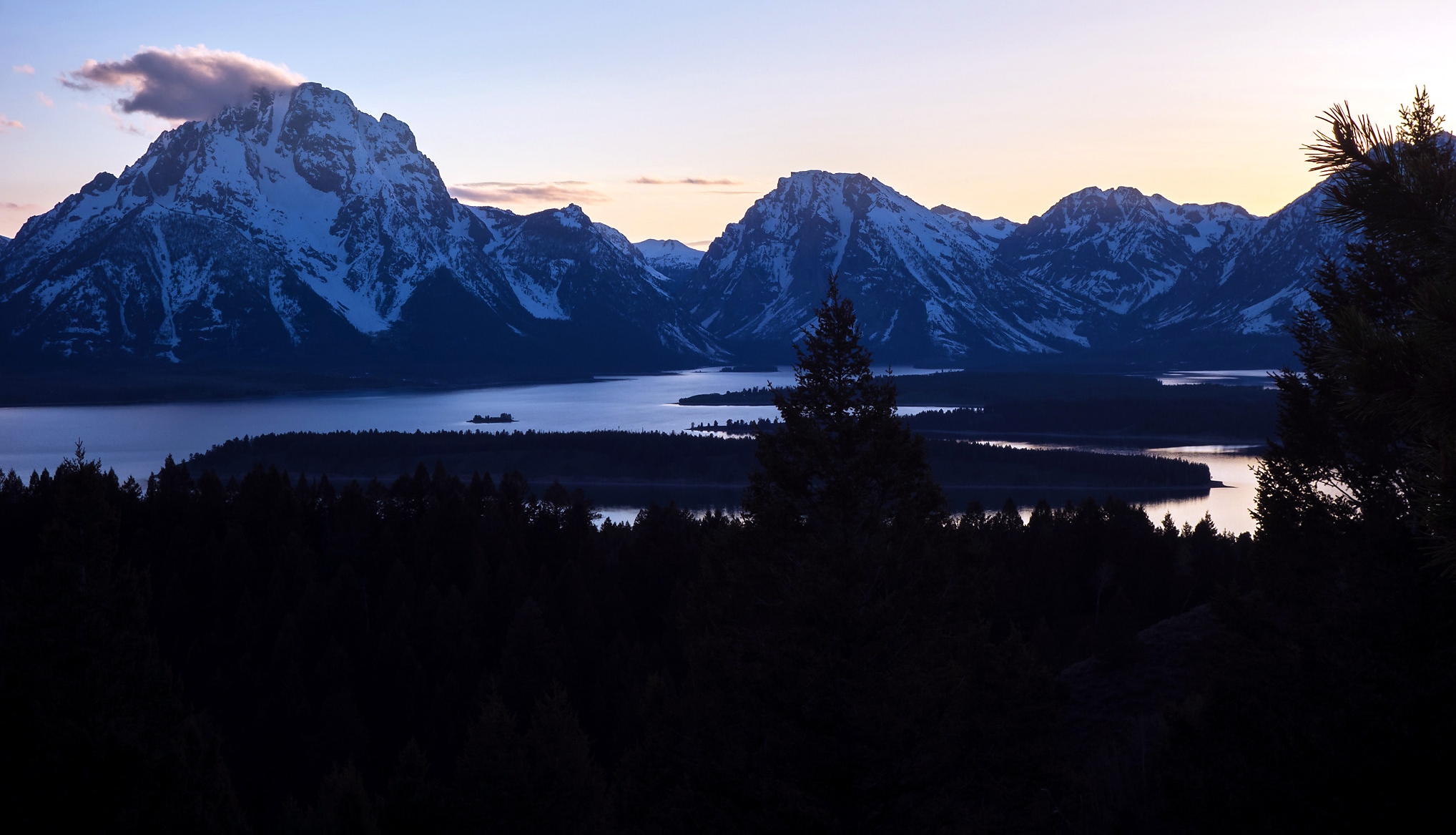
Another day, another journey to the north. Jane calls the park road hotline in the early morning, and a pre-recorded message tells us that the road break at Canyon is still a day away from being fully repaired. So it's back in the car, back over the Continental Divide, and back on another long ride through the geyser basins, this time bound for the town of Mammoth at the northwestern corner of the park. Jane flips through our satellite radio to kill time, settling on a standup comedy station that keeps us entertained for the rest of the ride ("Guns don't kill people, people kill people! Toasters don't toast toast, people toast toast!").  As we descend the hill from Madison Junction into the river valley, we are momentarily stalled by our first (but not last) herd of bison traffic. Carefully, I ease the rental car around and past the great beasts, eager to not startle any of them. In the early hours of the morning, we reach Gibson Falls and crest the pass to see steam rising from the Norris Geyser Basin below.  Our first stop of the day is roadside at Roaring Mountain, an eerie, barren peak rendered uninhabitable by its phalanx of fumaroles and hissing steam vents.  Even among the grotesqueries of the Yellowstone Caldera, this living, fiery mountain is a particularly unnerving piece of landscape.

There is long traffic stop caused by road repairs as we enter Obsidian Canyon, but when we finally get underway again,  what follows is a liberating descent from the mountain pass into Swan Lake Flat, a gorgeous expanse of tawny grassland dotted with  glacial kettles and rolling drumlins, with the snow-capped Gallatin Range rising imperially to the northwest, and the Washburn Range cutting across the winding meadows to our southeast. At the north end of the flats, we leave the car at the foot of Bunsen Peak, a hulking mountain that guards the pass into Mammoth.  With our daypacks and winter gear in tow, we set off up the mountain trail. 

The trail climbs gradually through regenerating lodgepole forest before emerging onto a steep hillside with views overlooking the Golden Gate Canyon, the descent toward town, and the northern reaches of the Gallatin Range beyond (above).  We follow the hillside up and onto a tall snowbank which persists along all the enclosed and north-facing nooks and hollows along the trail.  It is slow and icy going without crampons (not to mention dangerous, with steep drop-offs to the side of some ice caps), but we manage to inch our way forward with the help of old footsteps left deep in the snow. Past the first set of snowbanks, the trail swings across an open alpine meadow with easy walking through dirt and sage. We make our way up the switchbacks; Jane picks up a pine cone while I pause to enjoy the view over the flats (below). As we ascend, the northward view to the valley below continues to widen. We pass through fire-scarred blowdown and across talus slopes, and finally back into pine forest, with its attendant shade and layers of snowbanks stretching as far as we can see up the slope. Stymied by the flat rubber soles on our old worn walking boots, we stop a few hundred feet short of the summit to rest and enjoy the view before making the descent back to the car. We're used to this now: it wouldn't be our spring vacation if we didn't take on a mountain trail too early in the season.


On our way down the mountain, we spot, far below us,  a massive parade of bison coming south through the mountain pass to reach their summer pasture. Some hug the winding canyon walls as best they can, while others walk brazenly down the asphalt as if they built and paid for Park Loop Road; regardless, ungulate traffic has the right of way in Yellowstone, and we in our line of red brake lights can only sit back and admire.  Back in the car, we join the procession heading northward into Mammoth, stopping briefly at roadside to photograph the lovely fan of Rustic Falls, where Glen Creek drops precipitously on its way from the flanks of the Gallatin Range to join the Gardiner River in the east. A pair or ravens hops around the parking turnoff, scrounging for crumbs from tourists; we watch as they fly to their hungry nestlings in an alcove on the opposite canyon wall.

Mammoth is a bustling little settlement nestled at the foot of its world-famous travertine terraces and hot springs. This mountain of shapely silver and pink mineral deposits, sitting there on the hillside like the long-forgotten grand prize trophy of some divine sculpting contest, is visible from every part of town. At first a ramshackle dump of inns and saloons, Mammoth became a U.S. army outpost in the late 1800s when the War Department, sick of watching Yellowstone be run into the ground by a hapless civilian administration, deployed a company of cavalry to take control of the fledgling national park from poachers and profiteers. The military administration, with its regimented approach to chain of command, backcountry patrols, and tight regulations on wildlife and natural resource management, set the foundations for what was to eventually become the modern National Park Service, whose park headquarters remain located at Mammoth.

We stop first at the Mammoth Terrace Grill, where I order a cheeseburger and Jane orders a bowl of bison chili with rice ("Hot food!" we rejoice). After lunch, we walk to the boardwalks and stroll around the travertine terraces. These limestone deposits are a wonder to behold, built over millennia by the action of hot springs supersaturated with minerals, then rounded and sculpted by flowing water, and finally streaked in shades of pastel by thermophilic bacteria. They stand in lovely contrast to the lush green valley of the Gardiner River, and the eroded tongues of sandstone on the flank of Mt. Everts to our east.

After walking around the terraces, we take a brief detour to see Wraith Falls to the east before we resume our route home. Jane, ever wanting to see little spattering puddles of mud, talks me into stopping at the Artist Paint Pots, where we power-walk through nearly a mile of forest and climb a 200-foot hillside to arrive at what I can only describe as the most disappointing little spattering mud puddles I have ever personally seen.  Our tremendous gasping for breath, the bewildered disappointment of the other sightseers on hand, and the sardonic little "plops" of the vomit-beige mud bubbles - in combination, these things send Jane into fits of laughter.  We power-walk back to the car past families with strollers, grandparents with walkers, and one very sizeable woman who is struggling to make it past the parking lot bench - wanting very badly to tell them to turn around while they still can. The rest of our 1.5-hour drive back to the lake is uneventful. 

In the late afternoon, we get dressed and walk from our cabin to the Lake Hotel, where we have an early dinner reservation that I made when we booked everything else for the honeymoon (in true cruise ship/Disneyland fashion, the dining room tables book out early, and it can be a real struggle for the hungry tourist to find non-sandwich food here in the shoulder season  if he or she doesn't plan early).   With its pastel yellow paint job and quaint colonial architecture, the hotel is quite charming. We sit in the reading room for some time while our table is prepared, looking out onto the veranda and the azure blue water of Yellowstone Lake beyond.  Wisps of cumulus float through the mountains in the east, and a light drizzle begins to fall,  dappling the glass surface of the lake.  After perusing our dinner menu with its cheeky Papyrus font, we start with a set of lamb sliders with goat cheese. I order a bison tenderloin with mashed potatoes, while Jane has grilled quail on a bed of rice. The food is tasty but mostly forgettable, and we are both glad we didn't make any additional reservations for our stay.

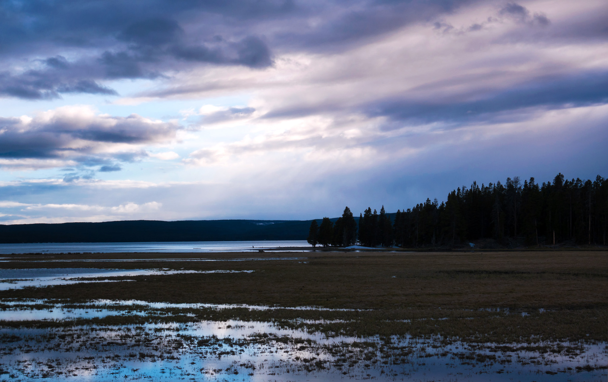
After our meal, I hang around outside while Jane relaxes in the cabin. With the  clouds drifting in, the chances of a brilliant panoramic sunset are slim, so we choose to stay close by for the golden hour. We drive a few minutes to the east along the north shore of the lake, stopping to watch a family of ducks on Indian Pond before settling at the outlet of Pelican Creek, just up the road from the trailhead to Storm Point.  The marsh where the creek empties into the lake is shrouded lavender purple as the sun falls to the west. The wetlands are still but not quiet; we are kept company by a choir of croaking frogs, with the intermittent splish-splash of trout breaking the surface. Jane watches for awhile with the binoculars, mostly spotting ducks and the occasional heron, before we head home for the night.

Day 5: Lamar

On our last full day in Yellowstone, Jane and I call into the park roads hotline to hear that the water main break at Canyon has been finally fixed, and that the pass under Mount Washburn, the highest and snowiest point on the park loop, is set to open on schedule. With these developments, the northeast corner of the park is accessible from the Lake area, and our vacation is able to proceed as planned.  We drive north through Hayden Valley and across the Canyon of the Yellowstone; after this, the road turns into the mountains, and snowbanks to the side of the road grow taller and taller. Just before entering the pass, we pause at a vantage point on the rim of the Yellowstone Caldera. Jane and I eat chunks of pepperoni bread while looking out across the wilderness, its endless miles of pine forest interrupted in places by stripes of riverland and columns of steam.

Now the road climbs sharply along the sides of the mountain, and we navigate hairpin turns through what feel like tunnels of ice. The mountains of the Washburn Range, with their broad, frozen peaks, rise up out of the white wasteland around us. The summit of Mount Washburn itself, which we would have loved to climb in warmer times, is shrouded in dense cloud, totally inaccessible without crampons and heavy winter gear.  We drive onward; on the other end of the pass, just as abruptly as we left, we are transported back to the land of lush river valleys. The road curves east before resuming a northward course, following the bank of the Yellowstone River (downstream now from the Canyon) to our right.

Our first stop of the day is roadside at Tower Falls, where Tower Creek plunges out of the mountains and toward the Yellowstone River below. The falls are named for the minarets of basalt that surround the lip of the waterfall; I spend some time trying to figure out how to best photograph these in relation to the falls themselves, but am unable to do so on account of a few lovingly intrusive pine branches (just off frame to the top left). A lower perspective would have been helpful, but though there was formerly a trail leading to the creek at the bottom of the falls, this has now been shut off due to erosion and overuse - a vivid  illustration (I could list many, especially in Yellowstone) of the American public quite literally loving its national parks to death.  I settle for a nice long-exposure shot of the falls, using the surrounding pines as a frame. Jane buys a cup of coffee at the Tower general store before we continue.

A few miles north at Tower Junction (west to Mammoth, east to the Beartooth Highway), we head east, following the road down the Lamar Valley, a broad riparian flatland that dwarves Hayden Valley in comparison.  Crossing the Yellowstone River, we pass a 20-car pileup and a bonanza of photographers that could only mean a gala reception for either grizzly or wolf (we later learn that there was a grizzly sow with  cub down by the riverbank).  We join another group of spotters further down the valley; with a little help, we're directed through our binoculars to a black bear and two cubs walking in a clearing on a distant hillside. We also see our first pronghorns, bounding along the valley floor like wind-up dolls, quite literally outpacing our car at highway speed. They are the fastest land mammals in the Western Hemisphere (and second in the world only to the cheetah!).

Mid-valley, the road and river curve north, running together toward the border with Montana. We stop here at the Lamar River Valley trailhead, descend a dirt path, and cross over Soda Butte Creek on a wooden footbridge. The trail places us in the center of the valley, nestled beneath the Yellowstone Plateau to the south, Druid Mountain to the west, and the peaks of the northern Absarokas to our east (bearing such wild western names as The Thunderer, The Needle, and Hurricane Mesa). We walk south toward the foothills, following the creek to where it joins the Lamar River.  We pass bison grazing and dozing contentedly on the riverbank, and pronghorn that watch us with suspicion and go bounding into the sagebrush as soon as we pass by. The greenery of the river valley, with its stands of willow and cottonwood, is a pleasant contrast to the pine forests we have been walking in.  Here in May, the ground is dappled with blooms of yellow violet and phlox; in the next few months, the entire valley will be splashed with a rainbow of  wildflowers.

Over the next few miles, we cross an old river channel that the creek has left behind, then climb up a steep hillside leading toward Cache Creek. Here, we get a sweeping westward panorama down the valley floor - snow-capped peaks, a river that winds into the horizon,  and the dots of distant pronghorn and bison herds. On top of the hill, we hear grunts and roars emanating from a nearby glade; ever alert for predators, Jane retreats back down the hill to get a better look. She finds the source: a bison fight club in a little dirt bowl under the hill. After I finish a few photos of the valley, we watch, bemused, as a pair of male yearlings headbutt each other.  The cows of the herd, with their little brown calves, sit around them in a circle, beside themselves with indifference. On our way back to the car, we are accosted by one bull who stands suddenly from his riverside bed of dirt, apparently spooked by Jane (who is generally louder in open meadows than enclosed urban spaces). We take a long semicircle detour into the sagebrush to avoid being charged, much to the amusement (or perhaps horror) of the people watching from the car park.

On our return trip, we stop roadside near Tower Falls to photograph basalt columns overlooking the Yellowstone River, before grabbing a lunch of hot dogs and coffee fudge / peach ice cream - such a pleasant ice cream pairing that I repeat it the next day at West Thumb. I buy a pack of huckleberry-flavored twists that taste more like silicone than berry. As we cross back over the mountains into the Yellowstone Caldera, a steady rain/sleet mix begins to pour down. We run into a herd of bison taking the route under Mt. Washburn, eager to use the newly opened road to reach their summer pasture, presumably in Hayden Valley. At the Canyon, we take a brief walk along the North Rim to catch a view of the Upper Yellowstone Falls, aflood with the melting springwater and the falling rain. We return to our lakeside cabin in the mid-afternoon to relax and pack for tomorrow; I head into the hotel's business office to transfer and back up my photos, as Jane's Macbook has died to commemorate our wedding.

That evening, we return to the highest hillside overlooking Hayden Valley to watch the sun set. I set up a timelapse as the clouds stream in over the Washburn Range, darkening the sky and casting a flurry of shadows over the valley floor and the Yellowstone River below.  A few wildlife spotters join us, setting up their tripods with their range scopes next to mine with my camera. As we review the day's finds (evidently, quite a few grizzlies and a gray wolf pack near Soda Butte that morning), one woman chimes in, "We saw two hikers dodge a bison near the Lamar Valley trailhead!  We were so scared something was going to happen to them!" "We were scared too!" we respond.

Day 6: Signal Mountain

The next day starts with sunrise on the north shore of Yellowstone Lake.  With Jane sleeping in, I take the car a mile west of the cabin and park roadside on an open stretch of shoreline with an eastward view. In the darkness, I set up my tripod and wait in the chilly lakeside air. The deep blue of the morning begins to lighten gradually. There is a low cloud cover that blots out most of the sky, and the distant Absarokas that I hoped to catch in timelapse are, unfortunately, mostly shrouded. But as the dawn comes over the range, waves of sunbeams begin to stream through the dissipating clouds, covering the shimmering glass of the lake surface with patterns of pastel pink, purple, and blue. One last, gorgeous sunrise beside Yellowstone Lake, and well worth the early morning.

Back at the cabin, Jane is just waking up. We collect our things (our once formidable food stores depleted to just a few juice bottles, trail mix, and the nasty huckleberry twists), load the car, and check out in the hotel's main lobby. We drive west around the north shore of the lake for the final time, heading south at the West Thumb road junction.  At West Thumb, a semicircular blast crater formed in an eruption of the caldera 70,000 years ago, the lake flows into a bay whose edges are lined with geysers and hot springs. We walk the boardwalk around the geyser basin, filled with geothermal features like the Fishing Cone, a tiny geyser where fishermen would catch and boil their trout on the spot through the park's early years. In the morning fog, the basin is quite eerie, its startling blue hot springs seeming to stretch into infinity, while the water beside the shore terminates in a white curtain where one knows there ought to be an entire lake with distant horizons of pine forest. Near the car park, we run into a female elk grazing beside the boardwalk. She walks within a few feet of us before ambling off to the other side of the basin. We also see a snowshoe hare munching on grass in its summer outfit - a brown overcoat with comically oversized white boots.

A mile south, we make a stop at Grant Village, a collection of dormitories, cabins, and general stores hugging the shore of West Thumb. The general store has an impressive cafeteria by Yellowstone standards (hot food!), where the two of us chow down on buttermilk pancakes, scrambled eggs, and bacon.  I go for another cup of fudge and peach ice cream (my last ice cream of the trip, I swear). Then we are southbound again, climbing over the lower edge of the caldera and past Lewis Lake. We leave Yellowstone at its southern entrance, where an impressive line of Memorial Day weekend traffic is waiting in the opposite direction.

We continue along the John D. Rockefeller Highway, named for the man whose land purchases in the early 20th century eventually led to the creation of Grand Teton National Park as we know it today. As we leave the mountainous Yellowstone plateau, the road descends sharply into Jackson Hole, a sunken valley between the Tetons to the west and the Gros Ventre Range to the east. Rounding the north end of Jackson Lake, the road turns ever so slightly to parallel the lake, and across the water, our sightline is cut by a massive wall of marine rocks crowned by a parapet of serrated peaks and hanging glaciers. One of the newest mountain ranges in North America, the Tetons rise abruptly, soaring 7000 feet up  from the valley floor with no intervening foothills or graduated slopes. This incredible relief is an artifact of tectonic uplift along the western side of the Teton Fault (upon which the mountains sit) and corresponding depression along the eastern edge (creating Jackson Hole), as well as the young age of the mountains - too young to have been significantly sculpted and weathered by wind and water,  like our gentle Appalachian range back home.  The result is a signature mountain landscape that is as picturesque as any in the world - the purple mountain majesties of "America the Beautiful".

We stop at the Jackson Lake Lodge  for a short climb up Lunch Tree Hill, a little rounded knoll behind the lodge that looks over willow flats, creek beds, Jackson Lake and Elk Island in the distance, and beyond them, the towering Cathedral Group at the heart of the Tetons. We walk back through the sagebrush and the cabin grounds beside the lodge, then spend some time browsing the hotel gift store and admiring its tall glass lobby windows facing to the west. Back in the car, we proceed south over the Snake River and to the southern shore of Jackson Lake; it is still too early to check into our lodgings at the Signal Mountain Lodge, so we continue a mile west to its namesake, a 1000-foot, pine-forested mound of glacial moraine and volcanic ash (from a Yellowstone super-eruption in distant geologic history). Conveniently, there is a vehicular access road that we ride to the west-facing secondary summit, and the east-facing main summit. To the east, there is a lovely expanse of green valleys and rivers curving toward the comparatively tame Gros Ventre and Wind River mountains of central Wyoming. To the west,  even from a thousand feet above the valley, the spires of the Cathedral Group, punctuated by the massive spear-point of the Grand Teton itself, all but loom over us from ten miles' distance. We head back in the early afternoon and spend some time familiarizing ourselves with the amenities at the Signal Mountain Lodge - a gas station, convenience store, gift shop (where we purchase two on-sale fishing hats for future hikes), two restaurants, a marina with boat rentals, and finally, our cabin behind the lodge, a rustic (ugh) little log affair with a hotel room's heart of gold.

In the evening, after dinner at the Trappers Grill (onion rings, cheeseburger, and cornbread with chili; I resist the huckleberry crème brûlée being paraded across the dessert menu), we return to the top of Signal Mountain to watch the sun set over the Tetons. In a clearing on the side of the mountain, the atmosphere is nearly festive as we are joined by several hikers and other photographers. We trade selfies with a few other travelers, after which I find a small spot in the dirt to set up my tripod and aim it through the trees. It takes awhile for me to pick a composition, but I settle on a timelapse of Jackson Lake (rendered a winding waterway by the pine forests on Donoho Point and Elk Island) in the foreground, and lenticular clouds dancing over Mt. Moran in the background. With the second camera, I walk around the clearing, mostly shooting toward Teewinot and the Grand Teton, as purple and golden sunbeams glint off their snow-covered flanks. In the distance, a dark oval glides across the water near Marie Island, bound for the shores of Hermitage Point; we assume it is a kayak or canoe until we notice a set of antlers skimming above the surface. Then the sun sinks behind the mountain, and a shadow falls over the lake and woodlands.  As we make our way down the mountain and back to the cabin on the shore, the distant snowfields and glaciers are glowing against the darkening sky, like nightlights mounted on the wall of a childhood bedroom.