Desert: The High Mojave

On a recent visit home to see family, I took a two-night trip with my mom to explore Joshua Tree National Park and its environs. Based out of Twentynine Palms, a sleepy Californian desert town with a nearby Marine training camp, we spent two days and two nights getting to know the park.

On the first day, we leave East Los Angeles in the morning and arrive at Twentynine Palms around noon. After a break at our hotel and a brief stop at the Oasis of Mara visitor center, we proceed into the high desert. We spend some time walking around the northern portion of the Jumbo Rocks area in the mid-afternoon.  A front of cumulonimbus clouds emerges out of the Coachella Valley and sweeps toward the desert - harbinger of a truly rare Mojave thunderstorm. We proceed west through the park, driving past Juniper Flats to the roadside overlook of Keys View, which is perched at the crest of the Little San Bernandino Mountains. There, I photograph a lone juniper on the mountaintop, and set up for a short-lived timelapse before advancing rain and distant lightning strikes force us off the mountaintop. We drive back down to the flatlands, through a brief and miraculous downpour that soaks the desert roads, and eat a dinner of pot roast and mashed potatoes at the Denny’s Restaurant in town.

On the second day, we wake early and drive to the southeastern portion of the park, where the Joshua forests, piñon pines, and granite terraces of the high Mojave give way to the creosote, ocotillo, and cacti of the Colorado Desert. Halfway to the southern entrance of the park, the road is lined for miles by cholla cactus, whose sinister barbs deploy at the slightest touch and are virtually impossible to remove. Standing amidst this desert garden, we watch the sun rise over the Pinto Mountains and the sandy wasteland below them. We then take a brief hike to see Arch Rock at the White Tank campground before returning to the hotel to rest and escape the mid-day sun.

In the late afternoon, we return to the high desert and drive to the western portion of the park, which, on account of its incredible granite formations, is called the Wonderland of Rocks. We walk the mile-long loop through a narrow valley path to Barker Dam, which has very little to do after a long and dry summer in Southern California. Afterward, we park at the Hall of Horrors for sunset. I wander off to explore the rock formations that give the area its name, and eventually boulder a short way up a rock wall to shoot sunset over the valley.

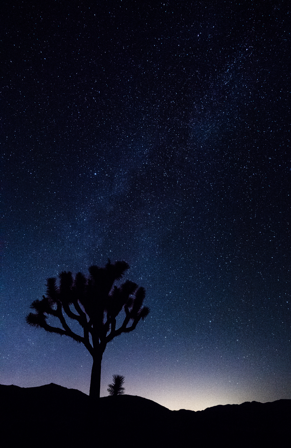
After dinner back at our hotel room, we return to the desert one last time, after sundown, to photograph the galactic core as it rises to the west. We proceed to the parking lot beside Cap Rock, which we drove past the day before, and which has a shapely Joshua tree standing just across the road from the parking lot - easily accessible in the pitch black of the desert night. Sitting in the soft dirt, I coach my mom through her first astrophotography session, and we take long exposures of the tree silhouetted by the stars - with the faint glow of Palm Springs lighting the horizon. The next day, we sleep in and have breakfast at the hotel before driving back to East Los Angeles, arriving at home shortly after noon.

Day 1: Yellowstone

On May 22nd, a day and a half into (formally) married life, Jane and I are taking off from Salt Lake City. A smoothie in hand, I watch as we lift over the  Utah salt flats and the snow-covered peaks of the Wasatch Mountains, on a northbound course over the rolling basin-and-range topography of the Mountain West. We ease into our descent in less than an hour, coming down over green grasslands streaked with glacial potholes and gravelly moraine deposits - the windblown, prairie-sweet landscape of central Wyoming. Cody Regional Airport, where we disembark, is a one-room terminal plastered in landscape photography and cautionary advice pertaining to bears. "Welcome to Grizzly Country," the entrance proclaims. Jane and I grab our backpacks and head out to the rental car lot; the air of mid-spring Wyoming is cool and crisp, a welcome change from the sun-soaked suburbs of Southern California. We find our olive-tinted Subaru Outback and make our way into town.

Cody is a wrangler's town. Main Street is lined with stores selling souvenir cowboy hats, actual cowboy hats, hunting rifles, Yellowstone paraphernalia, and the odd massage parlour. The biggest building in town is the rodeo, a massive amphitheatre with a dirt parking lot that hosts a crew of pickup trucks at any time of day or night. We drive west to the edge of town, where we make our now-traditional start-of-the-trip grocery store run at the Cody Walmart, which is laid out identically to the Walmart  in Golden Ring Plaza on the Route 40 in Baltimore (familiarity is an under-rated and pleasant thing in our travels). We make away with a stack of pepperoni bread, a box of chocolate donuts, a bag of tangerines, a rainbow of juice boxes, trail mix, an assortment of other fresh fruit, and a can of Pringles for good measure. Continuing our sight-seeing, we pop across the street and grab lunch at Arby's, where the menu includes a roast beef sandwich stacked with barbeque brisket, grilled pork belly, and onion rings. Fast food is, quite simply, on another level here in cattle country.

After lunch, we're finally underway on a 50-mile drive through the Absaroka Range to the East Entrance of Yellowstone National Park. Yellowstone itself is situated on an high plateau encircled by mountains. The outline of the old volcano's caldera is still quite apparent from several high points in the park, and the emotional experience of being there occupies a strange middle ground between visiting an amusement park (droves of tourists, themed restaurant menus, gift shops, carefully curated attractions) and sheltering inside a miles-wide geologic blast zone that could devastate the North American continent at any moment. As we drive (as is key in these moments of the trip), Jane falls asleep. We wind alongside rivers and sagebrush-covered canyons in the Wapiti Valley, climbing into the mountains ahead of us through light, passing showers.

In the mid-afternoon, we drive past the frozen surface of Sylvan Lake and over the mountain pass beneath Avalanche Peak, finally laying eyes on Yellowstone Lake, a massive sheet of blue in the caldera below us.  We pause at the overlook on top of Lake Butte, a granite stack close to the eastern shore of the lake, which provides fantastic westward views across the Yellowstone watershed and to the Tetons in the south. Afterward, we continue northwest along the lakeshore, passing through the campsite and general store at Fishing Bridge along the way.  By the roadside near Indian Pond, we catch our first glimpse of the American bison, grazing contentedly at the marsh grass,  its shaggy brown mane flecked with snow.

At the Yellowstone Lake Hotel, Jane waits in the car while I grab the keys to our cabin for the next five nights, a single-room, pastel-yellow affair romantically flanked by snowbanks in the parking lot. We unload our gear and our bags of food, which far outnumber our actual luggage at this point. "Honeymooooning," I croon at Jane while snacking on a potato chip. "Honeymooooning," she croons back as she throws her sweaty socks onto the windowsill. In the early evening, we walk down to the general store beside the lake in our sandals. As the sun disappears, the snow-capped Absarokas, across the water to our east, are bathed in a rosy glow of pinks and purples. We go to sleep early, with - for the first time in a long time - absolutely nowhere to be the next day, or the next day, or the day after that.

Day 2: Canyon

Morning by the lake. The space heater by our door has kept the little log cabin pleasantly warm, though the windows are covered in a layer of frost. After a breakfast of fruit and donuts, Jane and I step out into the blue world and pile into the car to catch our first sunrise in Yellowstone. Driving north,  we follow the course of the Yellowstone River past where it leaves the lake at Fishing Bridge, through the woods, past little hot streams that hiss and smoke as they empty into the current. Near the Mud Volcano geothermal group,  we stop the car and walk down through the trees to a rocky outcrop over the river; the sun rises over the valley to our east, behind the tops of the pines and the skyward plumes of steam.

In the light of day, the mist lying over the land dissolves and disappears as we enter Hayden Valley, a plain of crisscrossing creeks and green meadows formed over the ancient bed of a much larger Yellowstone Lake. Herds of bison graze placidly in the grassy flatlands on either side of the road.  At Trout Creek, we watch as a coyote, panting, chases a young doe across the water and beyond a rocky bluff; I am more entranced, however, by a lovely oxbow bend in the creek, where will we return the following day for sunset. Further north at a turnoff on the valley floor, a wildlife spotter calls us over to his mounted scope; he has spotted a rare grey wolf, one of the few reintroduced to the park in the past few decades, lounging on a hillside to the west of the road. It lets out a low, somber howl, but its packmates - if they are near - give no response. Leaving the valley, the road climbs through the trees to re-join the Yellowstone River at the most dramatic portion of its course.

The Canyon of the Yellowstone is 24-mile gash in the earth formed by the Yellowstone River as it makes the steepest drop on its journey cross-country to join the Missouri River. The result is an immensely beautiful corridor of rocky pinnacles and oxidized rhyolite deposits, capped by the torrential veil of the Lower Yellowstone Falls at the canyon's head.  We leave the car on the South Rim and walk to Artist Point, a rock balcony that juts out from the canyon wall, affording a classic view of the falls and the winding canyon upriver. To our north, the Washburn Range rises imperially toward the big sky. The few tourists on the North Rim (a water main break has cut the Park Loop Road and made the northern half of the park much less accessible for the first few days of our trip) are tiny specks on the opposing canyon wall. We take a few photos together on the balcony, then set off walking along the canyon rim, toward the falls.

Soon after leaving the road, the South Rim Trail climbs and follows to contour of the canyon wall. Though we are in late May, spring has just barely arrived in the Mountain West, and the trail is largely still a snowbank packed several feet deep. Along the most exposed stretches of the climb, where the canyon to our right drops dizzyingly away to the roaring river several hundred feet below, a wooden fence provides an almost laughable veneer of security - a vain piece of amusement park in an utterly wild place. Ignoring the fence, Jane and I hug the inner edge of the trail, tiptoeing our way along the icy snow, and sinking our feet, step by step into the safety of old bootprints.  We reach a gorgeous, snow-free outcrop nearly above the Lower Falls, and sit for a moment to admire the cataract of snowmelt as it rushes into the canyon below.

Beyond this spot, the trail devolves into a snowfield several feet deep and layered with ice. We bend over to read a trail map peeking through the snow to the level of our ankles, which indicates that Uncle Tom's Trail (the famously steep iron staircase that leads down the canyon and to front of the waterfall) is closed, as if we needed any more convincing to stay away from the canyon edge. We turn upslope on the trail, emerging at a parking lot closed for construction.  One of the construction workers chastizingly tells us that we shouldn't be there for our own safety, and nearly turns us back  into the woods before we point out the illogic of making us descend the snowfield for our own safety. He lets us walk out to the road, where a couple from Florida is kind enough to let us hitch a ride in their van back to Artist Point.

Our misadventures on the canyon rim at an end, Jane and I drive back toward the lake, munching on spicy Southwest trail mix and tangerines as we pass through Hayden Valley once again. We stop briefly to walk the boardwalk at the Mud Volcano thermal area, where several pools of vaguely interesting but decidedly unexciting mud froth and bubble and spew at us. We return to the Lake Hotel shortly before noon, stopping  first in the hotel café, where I devour a turkey sandwich and Jane a bowl of minestrone.  After lunch, we take a brief stroll along the lakeside to the general store, where the presence of an ice cream counter is duly noted. Satisfied with this finding, we return to our cabins and settle in for a cozy afternoon nap.

In the late afternoon, we set off again, driving east along the lake to a trailhead at Indian Pond. We follow the meadow path around the edge of the ancient blast crater, skirting around a male bison grazing at the water's edge. As the trail dives into the woods surrounding Storm Point, Jane becomes antsy, urging me to stay close and chafing a bit at my frequent stops for picture-taking. On the north shore of the lake, we are in prime grizzly country, and the prospect of startling a bear in the woods during breeding season is not a pleasant one. It would certainly be a fitting, but unfortunate and fleeting, end to our marriage for one of us be devoured by wildlife during our honeymoon. Fortunately, we are kept company by another hiking family - a father with his two girls, whose shouts of glee ring loud and clear through the pine forest. At Storm Point, we walk out onto a grassy promontory fringed by sand dunes. We sit for a moment on the rocks atop of the point, with Yellowstone Lake stretching away in every direction. "This is a really big volcano," I murmur. Jane is too busy keeping watch for bears to worry about vulcanism. We set off walking along the sand dunes, dodging around another bison grazing in the meadow. Back through another stretch of pine forest - we are startled more than once by the sound of a falling tree branch, or the snap of a twig - and we arrive back at Indian Pond.

In the car, we stop by Fishing Bridge for dinner on the road. I have a tuna salad sandwich; Jane gets turkey and cranberries. We wash these down with strawberry milk, then sit for awhile on the porch outside the gift shop with an ice cream bar, killing time before sunset. As the daylight begins to fade into gold, we climb back in the car and return to the east, to top of Lake Butte, where film to see the sun setting over a sea of burnt trees. I set up for a timelapse while Jane along the road with the spare camera. As the camera snaps away over the following hour, we excitedly try (with our one bar of WiFi here in the Wyoming backcountry) to download an email from Reuben, our wedding photographer, who sent us some previews from our wedding day. As the sun disappears beyond the western edge of the caldera, we pack away the tripod, driving back to our cabin at the lake in the growing dusk.