Oregon: North Coast

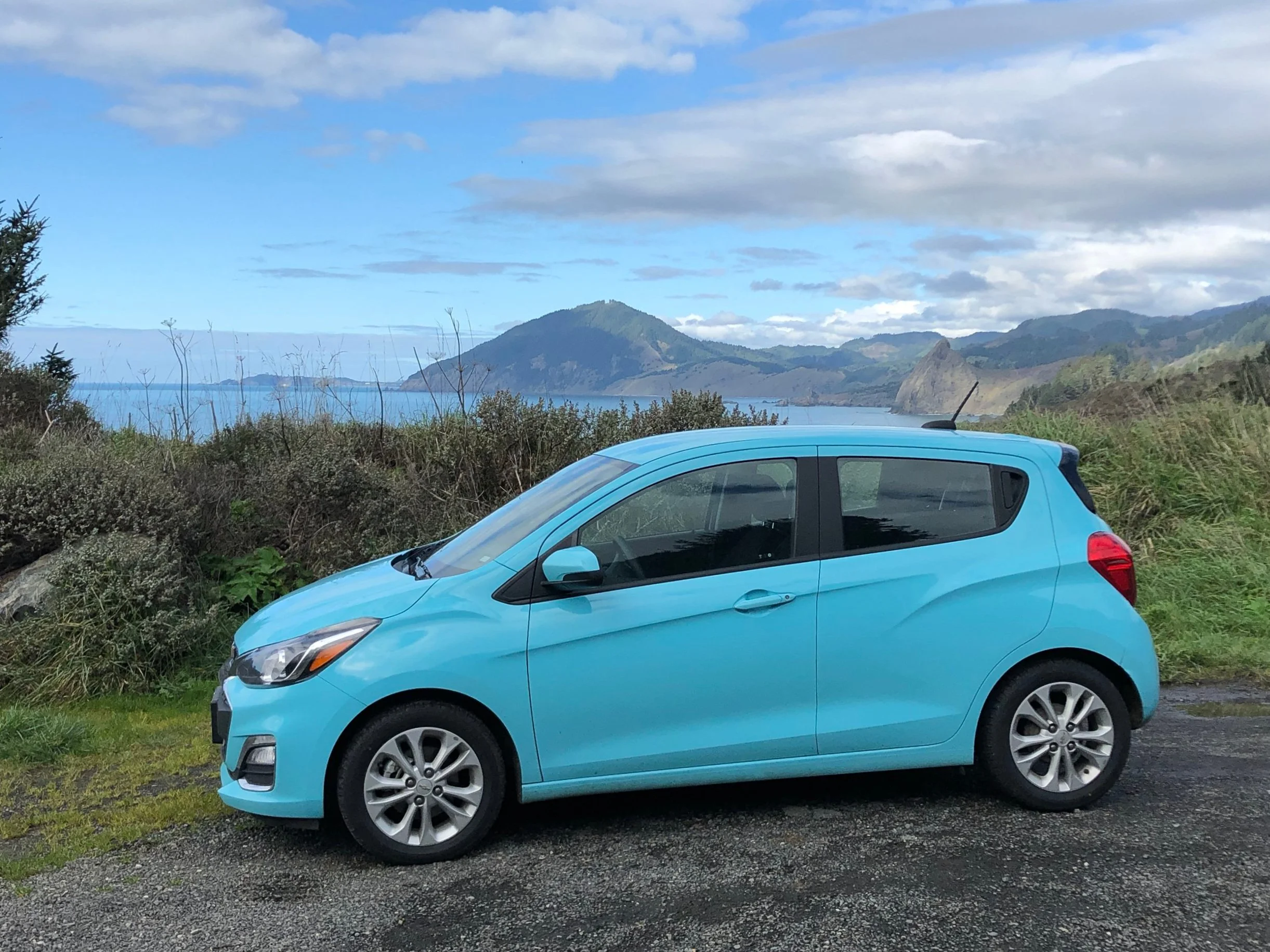
It’s nine in the morning, local time, as our plane glides down onto the runway at SeaTac. We have just crossed over the Cascade Range, which rises to the east in a miasma of cloud and snow-covered peaks, towering over layers of emerald forests, lakes, and the suburbia of greater Seattle. I’m tired after an early wake-up in Boston, and just a bit bored and lonely traveling on my own while Jane holds down the fort at home, but the view from the window seat sets my sleepy heart aflutter. It’s my first stint in the Northwest since a family vacation 13 years ago, and the prospect of immersing myself in a different landscape - one of towering, old-growth forests and gleaming coastlines - has been haunting me for years. In Seattle, I find my outbound gate (standing room only) and eat an early lunch before boarding the quick hop-flight down to Portland. Again in the north-facing window seat, I watch as the glaciated summit of Rainier, the collapsed caldera of St. Helens, and the distant, lonely cones of Adams and Baker pass us by. Crossing over the broad delta of the Columbia River, with its treacherous sandbars and seagoing barges, we descend into Portland. I pick up my rental car, a baby blue-teal Chevy Spark that I promptly name Blooty (after Jordan’s nickname, “Booty”), and head out onto the highway in the early afternoon.

Why the draw to the Oregon Coast? To the Pacific Northwest? For one thing, the region is one I’ve experienced too little of. High desert, low desert, chaparral, deciduous woodland, and a smattering of tundra and taiga in the north and on island peaks, have been my landscapes of experience over the past twenty years; outside of brief trips along the Sunset Coast, Cascadia’s unique blend of glaciated valleys, tidal dunes, cedar swamps, and temperate rainforests has been sorely absent. For another, a major reason why I photograph is to describe the natural world, and the beautiful ways in which ecology interacts with the human element - the way that landscape shapes our memories and our view of our place in the world. There can hardly be a holier Grail, for a woodland photographer like myself, than the coastal old-growth of the Northwest, where some of the oldest, tallest, largest organisms in the world dwell in some of the most biodiverse ecosystems on the North American continent. And lastly, perhaps for the same reasons as above, some of my favorite professional landscape photographers hail from the region - from Oregon, Washington, or beautiful British Columbia - and it has long been a dream of mine to follow in their footsteps. For all of this, I’m spending five days driving down the length of the Oregon Coast, from Cannon Beach to Brookings, and exploring some of the region’s coastal towns, beaches, and well-preserved forests.

On the highway, the Portland traffic (substantial even mid-day on a Saturday) thins out as I cross over the Marquam Bridge and skirt the city, heading westward toward the coast on Route 26. As the road climbs over the Coast Range, the landscape transforms from a rain-spattered scene of lush green farmlands to one of deep valleys, pine forests, and mist-laced mountainsides. In the car, I’ve got on an impressively moody, heavily acoustic playlist that I’ve concocted just for this solo trip. The next few days of serenity and introspection will be powered by the likes of Daughter, Noah Gundersen, Sigur Rós, Sufjan Stevens, and multiple Life is Strange soundtracks. A guitar/mandolin mix of Led Zeppelin’s “Going to California” comes on as I descend toward the coast; driving alone, I belt out Robert Plant’s lovely folk lyrics by heart.

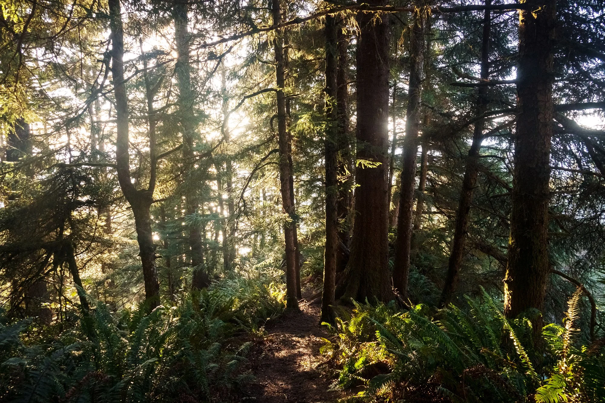
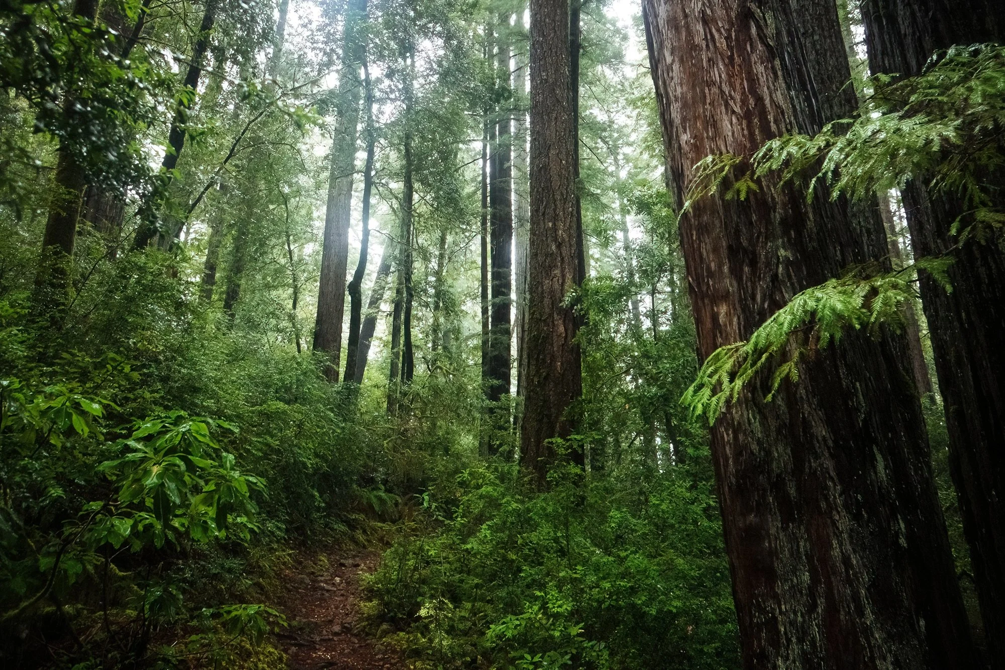
The major (and only) stop of the afternoon, after roughly two hours of driving since leaving the airport, is Ecola State Park on Oregon’s North Coast. I park the car at Ecola Point, where there is a vast view stretching to the south: breakers coming in across Crescent Beach and, past the next headland, crashing upon the sea stacks beyond Chapman Beach and Cannon Beach, where I’ll be lodging for the night. After paying the day-use fee at a kiosk and popping my ticket onto the dashboard, I fish my camera gear out of my suitcase, ditch my leisure reading book in the car (Heart of the Raincoast by Alexandra Morton and Billy Proctor), and set off on the trail to Crescent Beach. The walk meanders through the forest back in the same direction of the entrance road, winding through stands of Sitka spruce, pine, and cedar. Although I’ve intentionally timed the trip for the rainy winter months (with hopes of acquiring both solitude from other humans, and some moody atmospheric photos), today is an absolutely perfect weather day on the coast; the afternoon sun is gleaming through the tall trees, and impressively blue skies are beaming down on the beaches and coves below. The track through the forest is quite easy (if muddy in places, as trails will tend to be for the entire week), but I hike at a snail’s pace, soaking in the surroundings and breathing in the fresh forest air (also, it’s always impossible to resist photographing anything and everything on the first outing of a trip). In one of the loveliest segments of the trail, the walk crosses over Waterfall Creek, above a glen of enormous spruces and below a hillside of towering pines; golden sunlight is streaming into the scene at a low angle, casting lovely shadows and interplaying areas of light and dark throughout the forest. I take plenty of shots.

The last half-mile of the trail descends steeply along multiple switchbacks to arrive just above the wrack line on Crescent Beach. I am alone on the beach; to the distance in the north, I can make out my starting point on the headland; to the south, a series of impressive sea stacks and sheltered coves. I spend a bit of time here before undertaking the steep climb back up the hillside to rejoin the trail. Golden hour is approaching now, and the forest looks all the more lovely in the hues of the oncoming sunset.

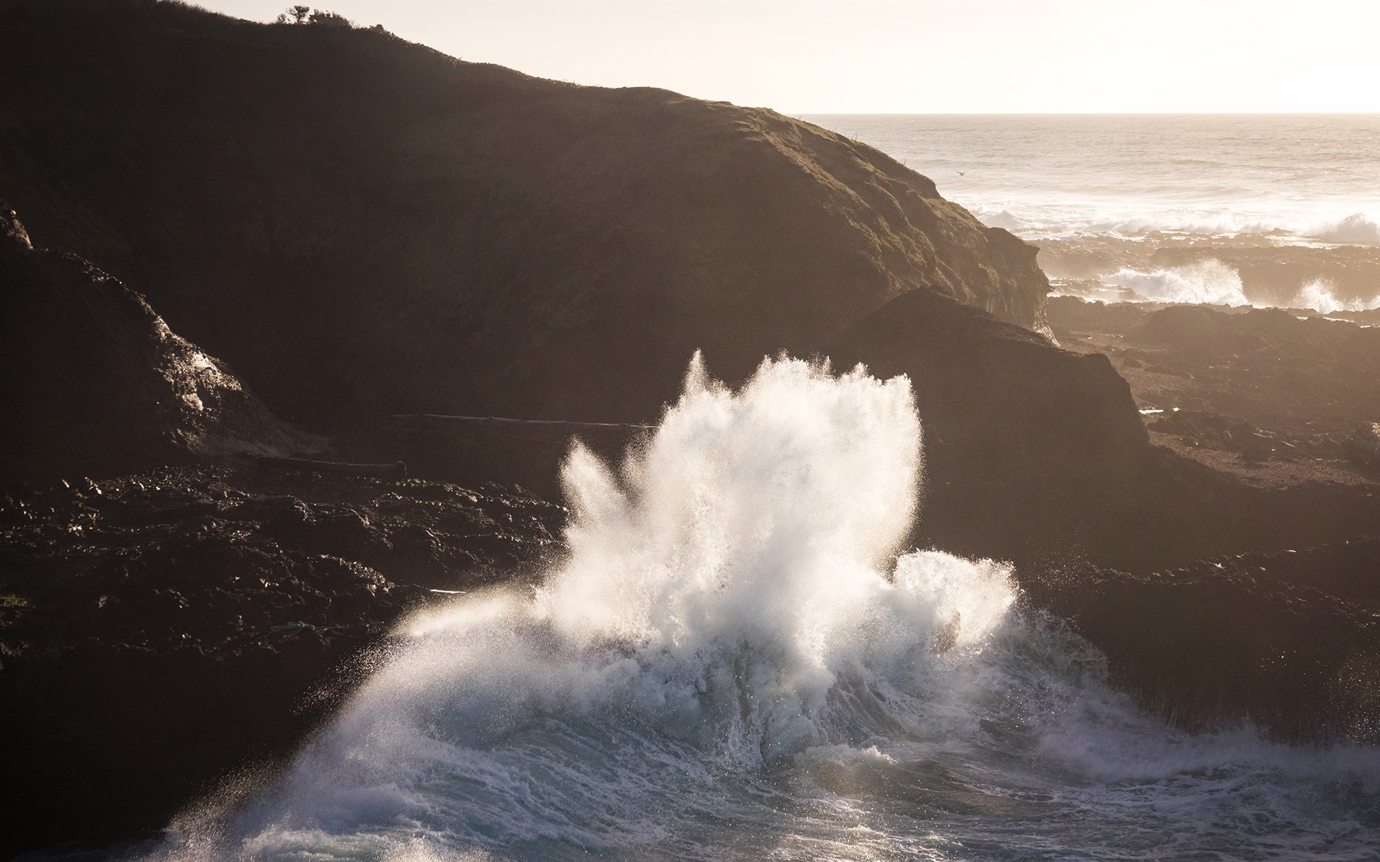
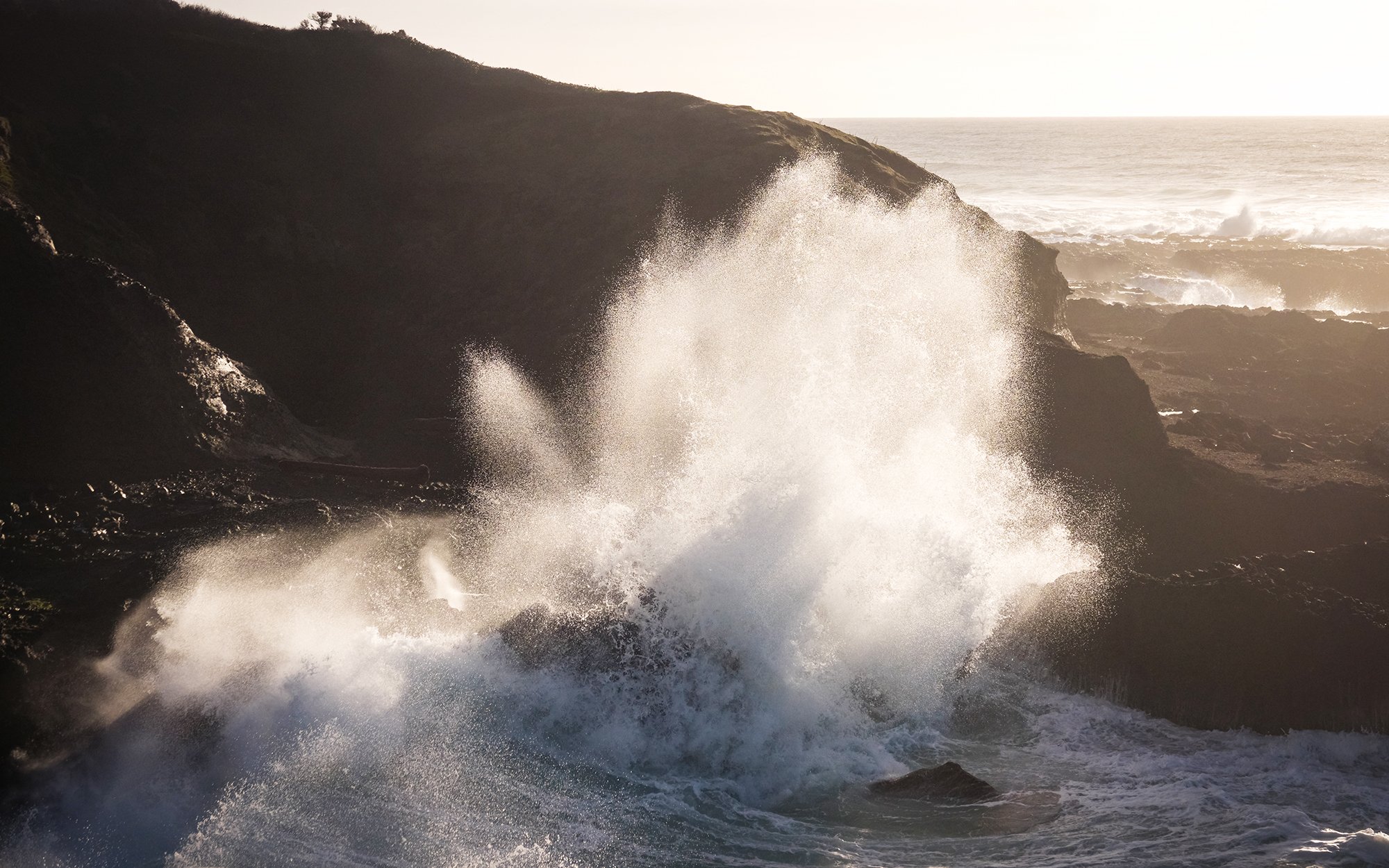
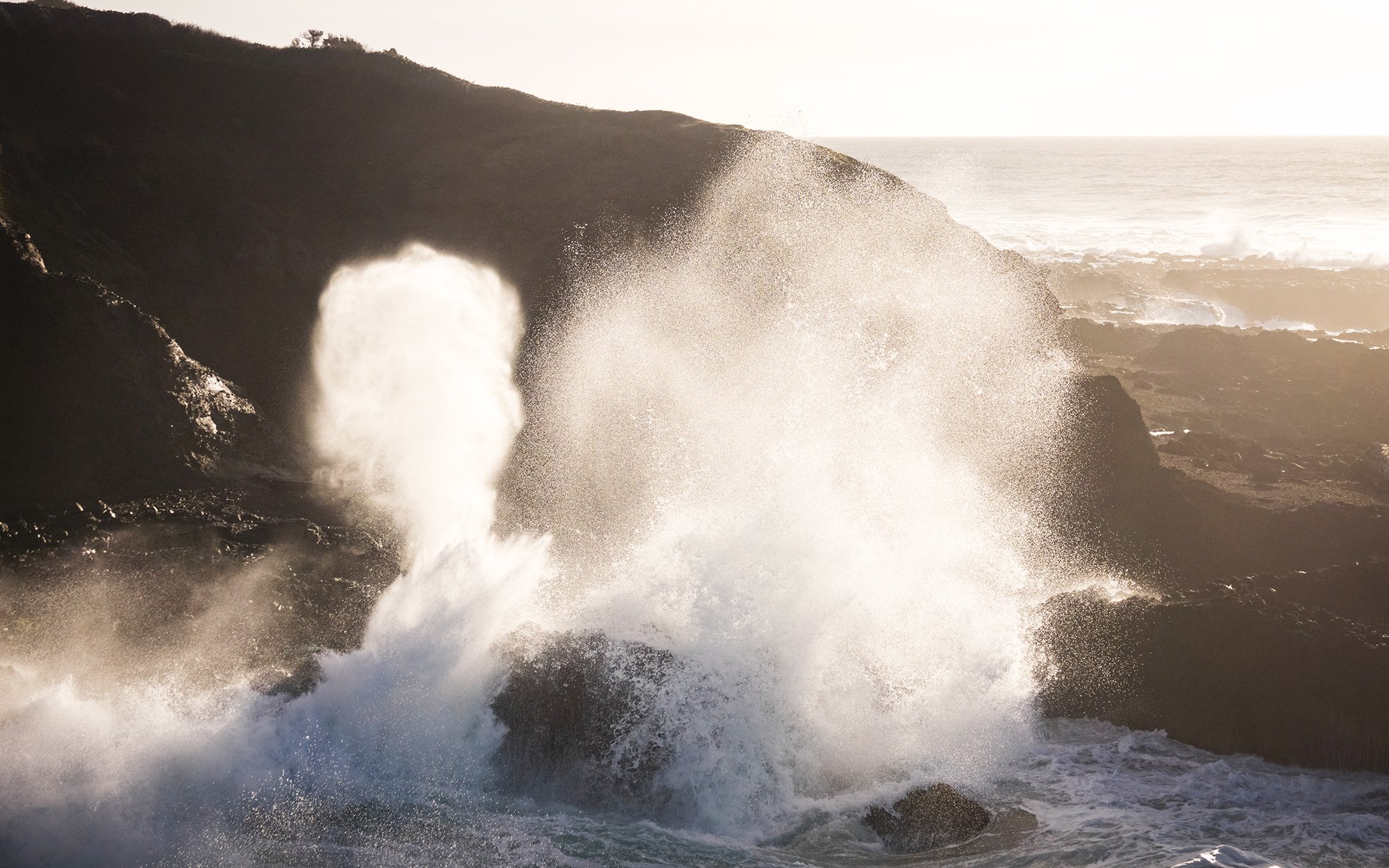
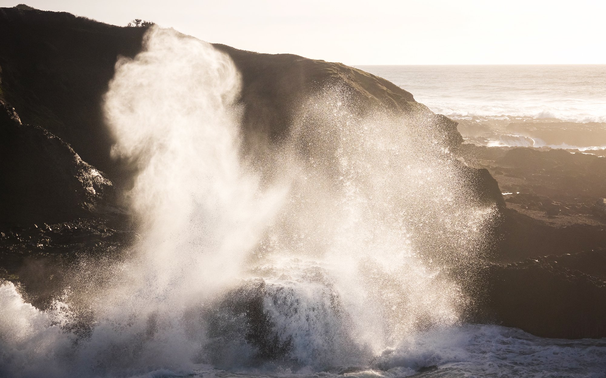
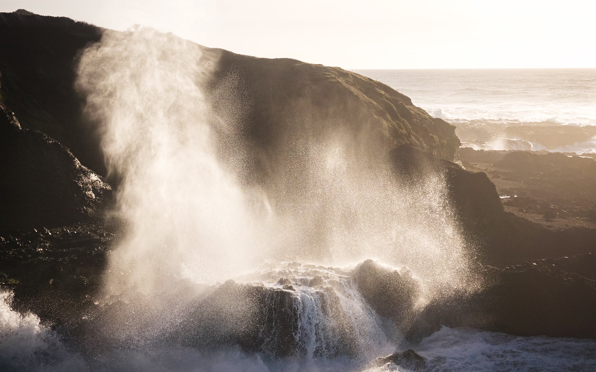
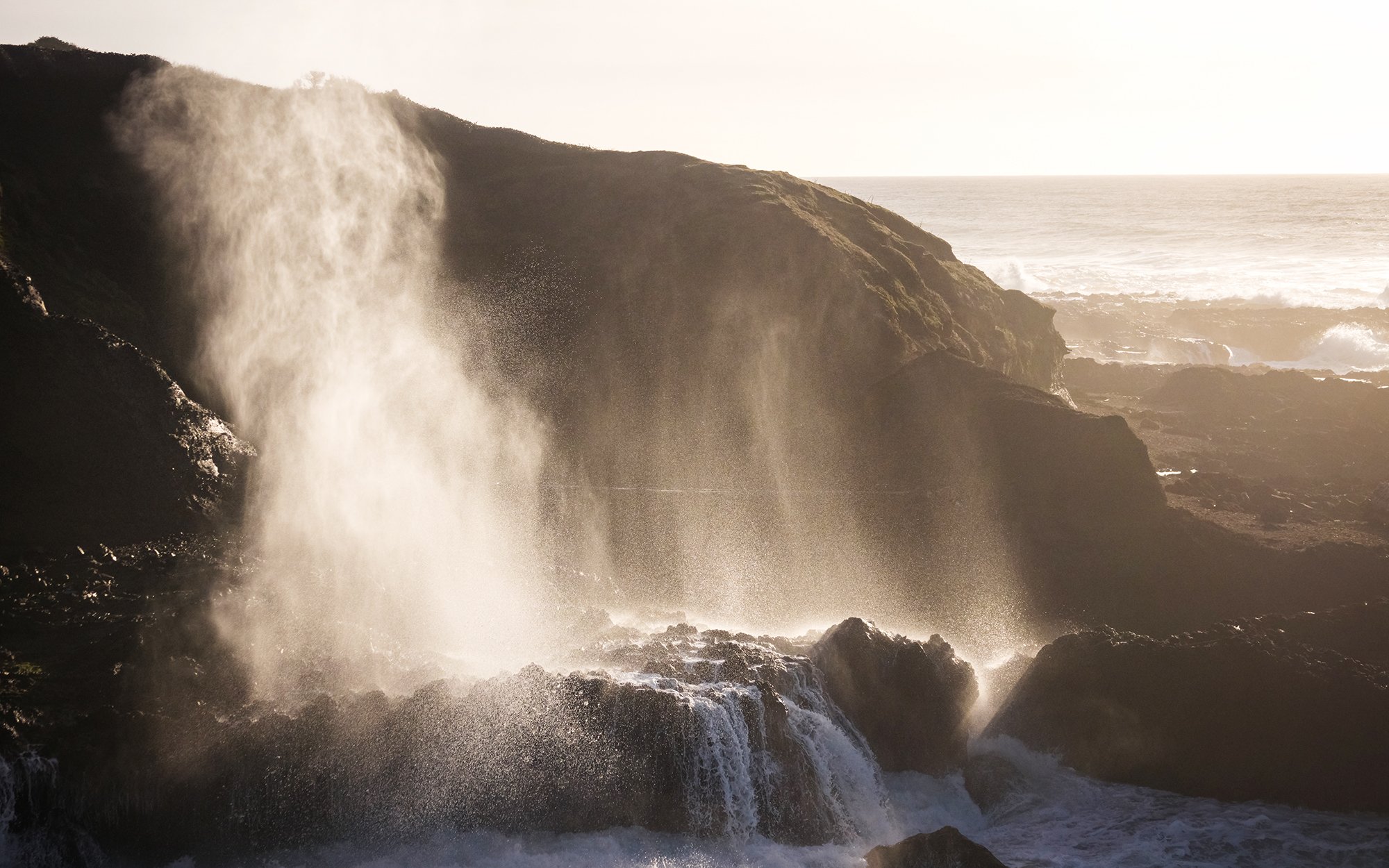
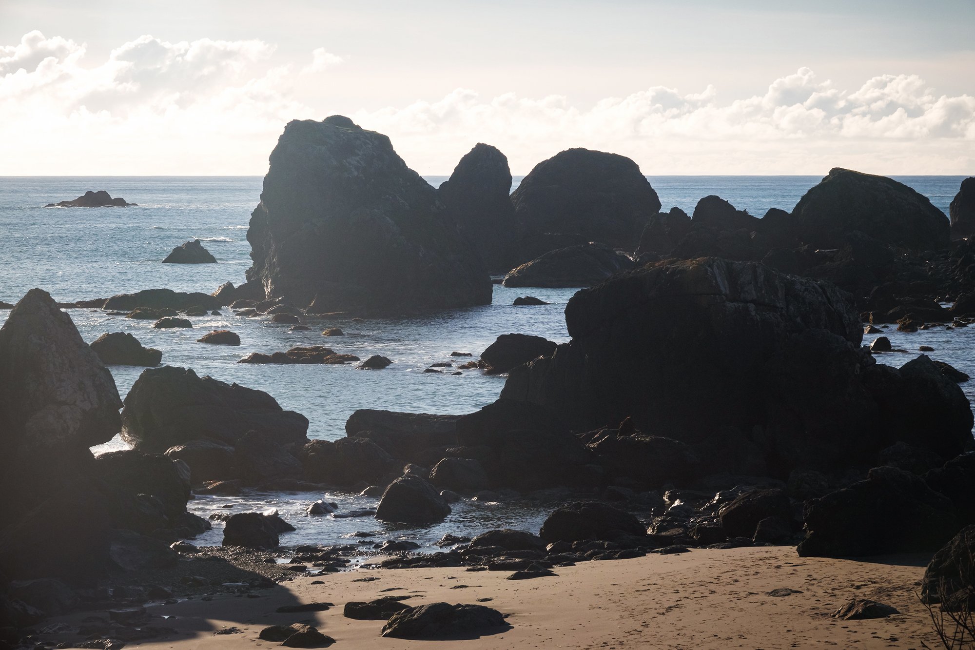
Back at Ecola Point, I towel off the sweat I’ve worked up on the return climb from the beach, and swap my layers for my windproof jacket. A few photographers have begun to set up on the headland overlooking the beaches to the south, and I join them with my tripod. The scene is a stunning one - with cliffs, sea stacks, and forested promontories in the foreground, and the mountains of the Coast Range in the background, looking austere and majestically strewn with low-lying cloud. The seaside community of Cannon Beach appears as a tiny line of houses in the midst of all of this, between beach and forest. I mostly take some simple telephoto compositions of Haystack Rock and its surrounding sea stacks, and some panoramas of the entire scene. I try some long-exposures, but find that I vastly prefer to preserve the detail of the wave action; the background clouds and mist already lend enough smoothness and cleanliness to the image. As sunset approaches, what began as an initially promising golden hour turns out to be a bit of a skunk as the sun drops into a dense marine layer building up off the coast. The light fades suddenly and aside from a bit of magenta color in the high clouds, there’s not much light or color to be seen - much to the chagrin and ill humour of the photographers present with me on the bluff. I will soon learn that the sun’s going to be doing this disappearing act a lot over the next few days; sunset photography on the Oregon Coast, in winter, it turns out, is as much about luck as it is perseverance or preparation. Still, the photos I do keep (above and below) are quite pretty in their own right. As the skies darken, I drive back down the winding road toward Cannon Beach, and check into my room for the night at nearby Ecola Creek Lodge. It’s a perfectly cromulent little room, and it comes with a free chocolate chip cookie. After a very, very long-awaited hot shower, I make myself dinner (packed from home - you guessed it - instant ramen, tuna fish, dried seaweed), enjoy my cookie with dried fruit and a cup of hot tea while watching cooking shows on TV, and pass out early into a deep sleep.


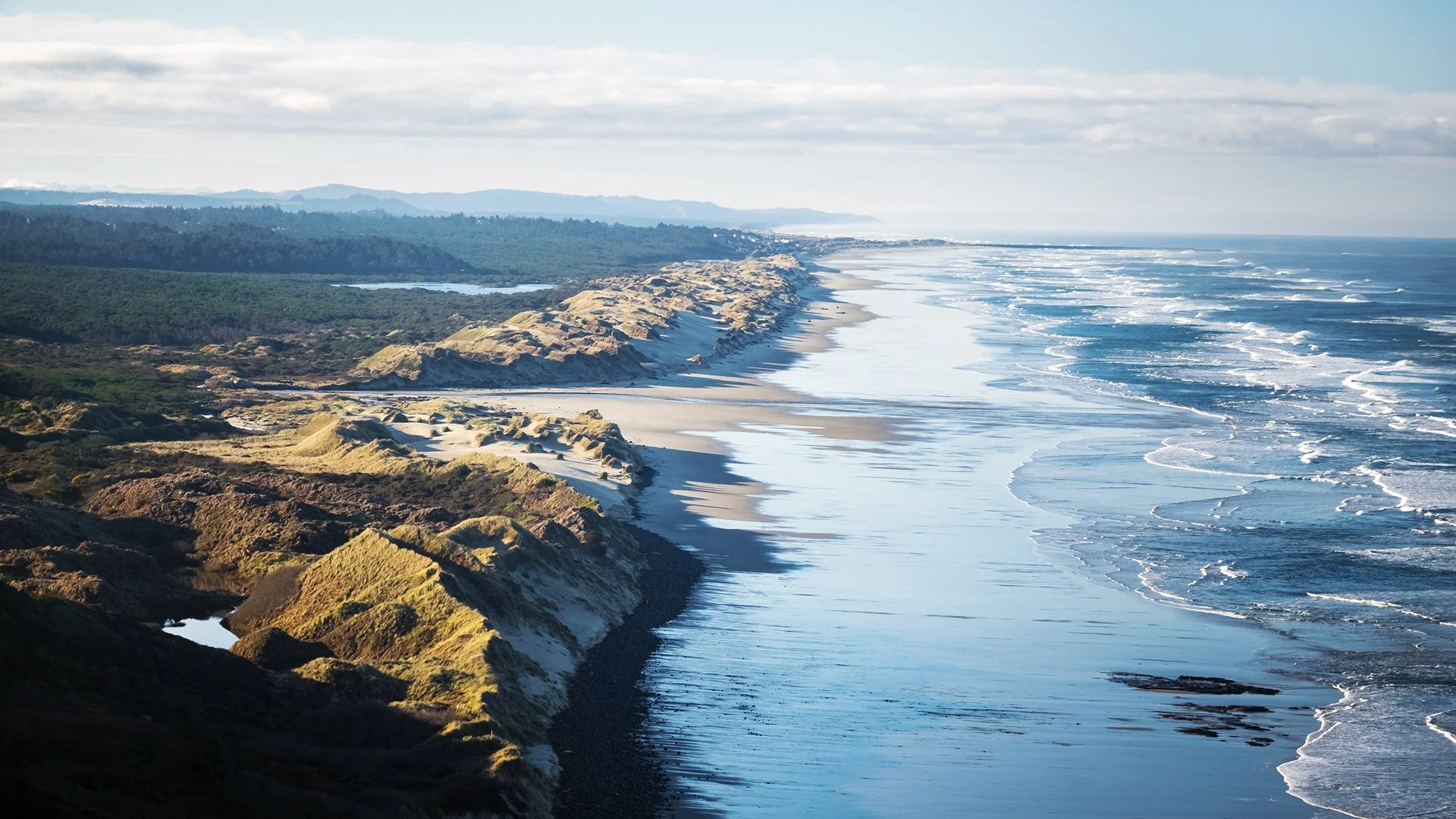
Day Two. Jetlag getting the better of me, I wake in the dark well before my alarm. The pitter-patter of rain is coming down in the lodge’s courtyard koi pond, and I peek between the window blinds to get a sense of how wet the outside world is. Very wet, is the answer. In a polar reversal from yesterday’s good weather fortunes, today the pitter-patter, to varying degrees, is going to be with me from dawn to dusk, from Cannon Beach, past the Three Capes, to Pacific City. After a sad-kazoo breakfast (I didn’t pack any breakfast foods, and I haven’t gotten to a grocery store yet, so it’s just nuts, jerky, and fruit), I pop on my rain layer and my backpack’s rain cover, and head out down the street and up a hill to access the dunes at Chapman Beach. It’s the blue hour, and sunrise is nowhere to be seen on account of the low-lying cloud cover and misting weather. The dunes are packed and firm in the rain, and I walk along them, taking shots of the vegetation together with flocking gulls and distant views of sea stacks to the north and south. The photos don’t do a great job of conveying quite how high I am above the beach (there’s a decent fifty-foot dropoff which appears suddenly as I approach the edge of the dunes; I decide not to risk what looks like an uncomfortable and pointless descent toward the ocean, which is roaring even at low tide. As I traipse through the grass, the light falling mist turns into full-blown horizontal pelting rain. Getting utterly soaked, I make a hasty retreat back down the street to the lodge, where I towel off my own body and my camera body before checking out. On my way out of town, I make a quick pit stop at Fresh Foods where I buy bananas, juice boxes, and several breakfast sandwiches to last me the next day or two. Then it’s onward to the south, to a pair of morning hikes at Oswald West State Park. I send Jane a quick text to let her know where I’m headed and that I’ll be in and out of cell coverage.

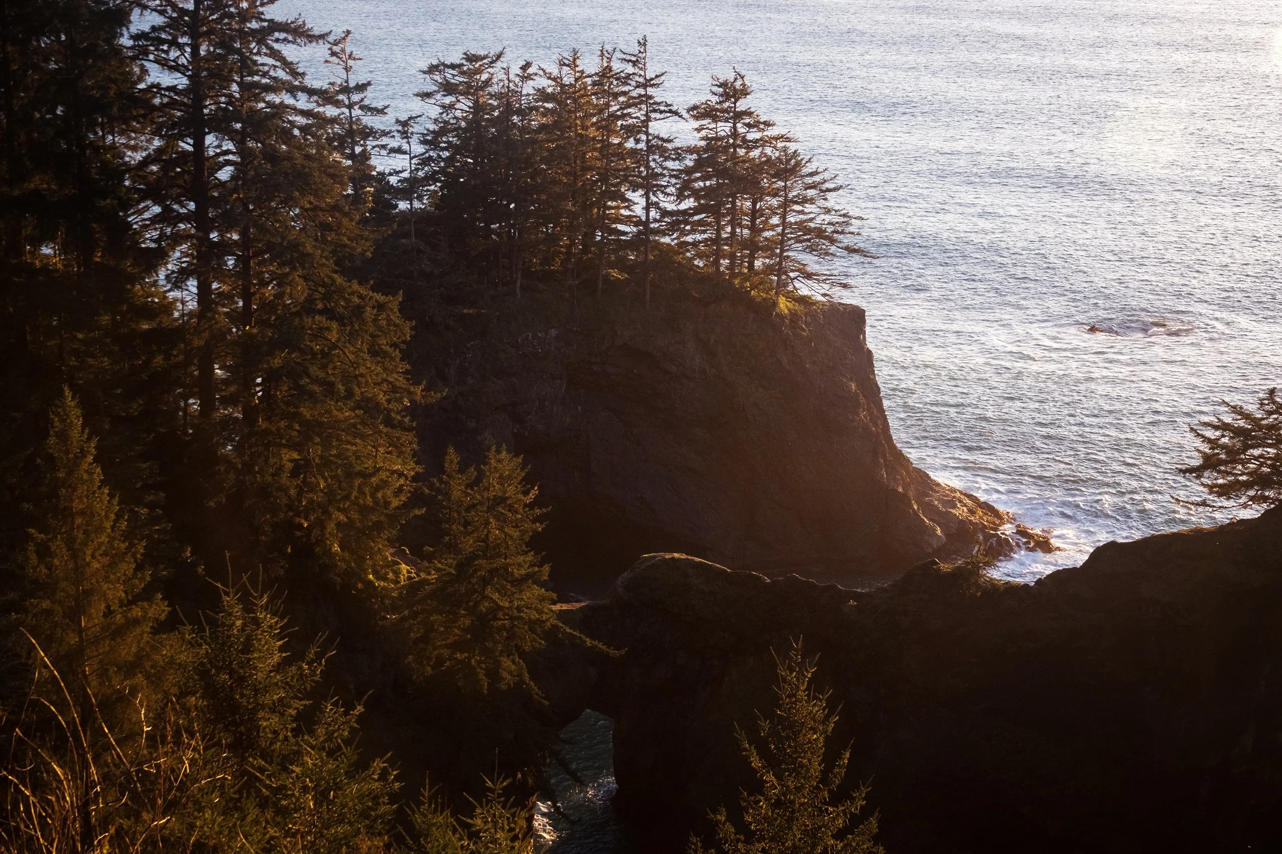
A few miles to the south, after a snack in the car, I head out to Short Sand Beach along the Cape Falcon Trail. The way to the beach is blanketed in a forest of spruces and hemlocks, mixed in with the occasional western redcedar, tall and imposing. Walking along beneath the canopy, I am shielded from the ongoing rainstorm, which is reduced to a fine mist that falls on the understory of salal, Western sword ferns, and salmonberry bushes. It’s a lovely environment, if quite wet and muddy - and it’s all I can do to stop myself from taking a photo every few yards along the trail. It’s here that I first run into a technical issue that becomes increasingly problematic on the trip’s wetter days: the tradeoff between using CPL filter to cut through leaf shimmer and appropriately render the forest’s deep colors, versus the moisture and condensation that builds up the filter and the camera lens. You can see this in some of the smudged highlights on the photos below. At the beach, the forest opens onto howling wind and horizontally blowing rain flying in off the stormy seas. I take a quick photo of the beach - its piles of driftwood flanked by basalt and sandstone cliffs - before retreating back into shelter beneath the trees.

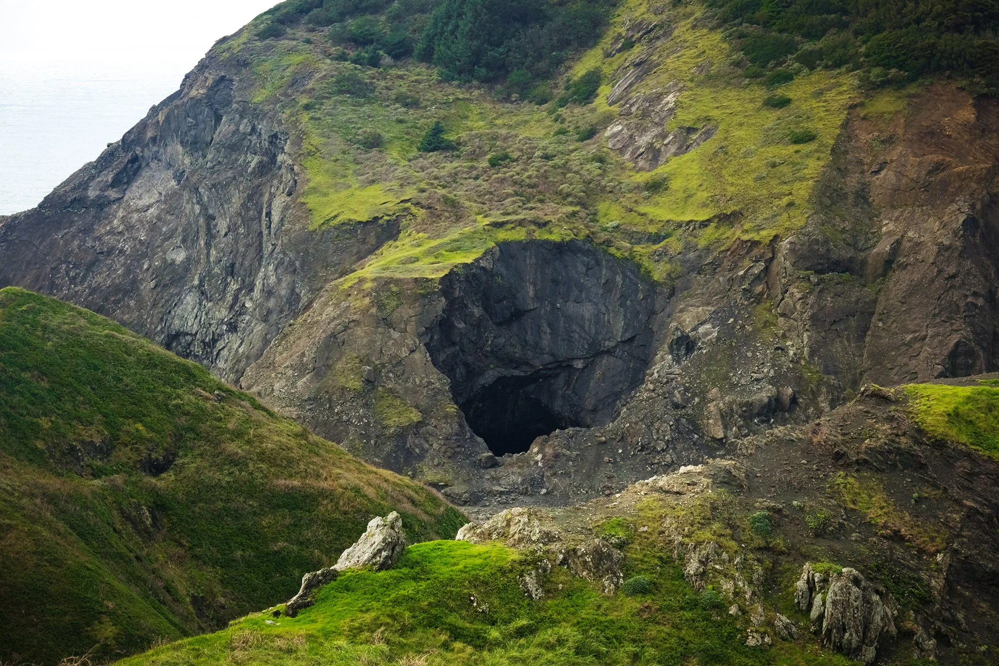
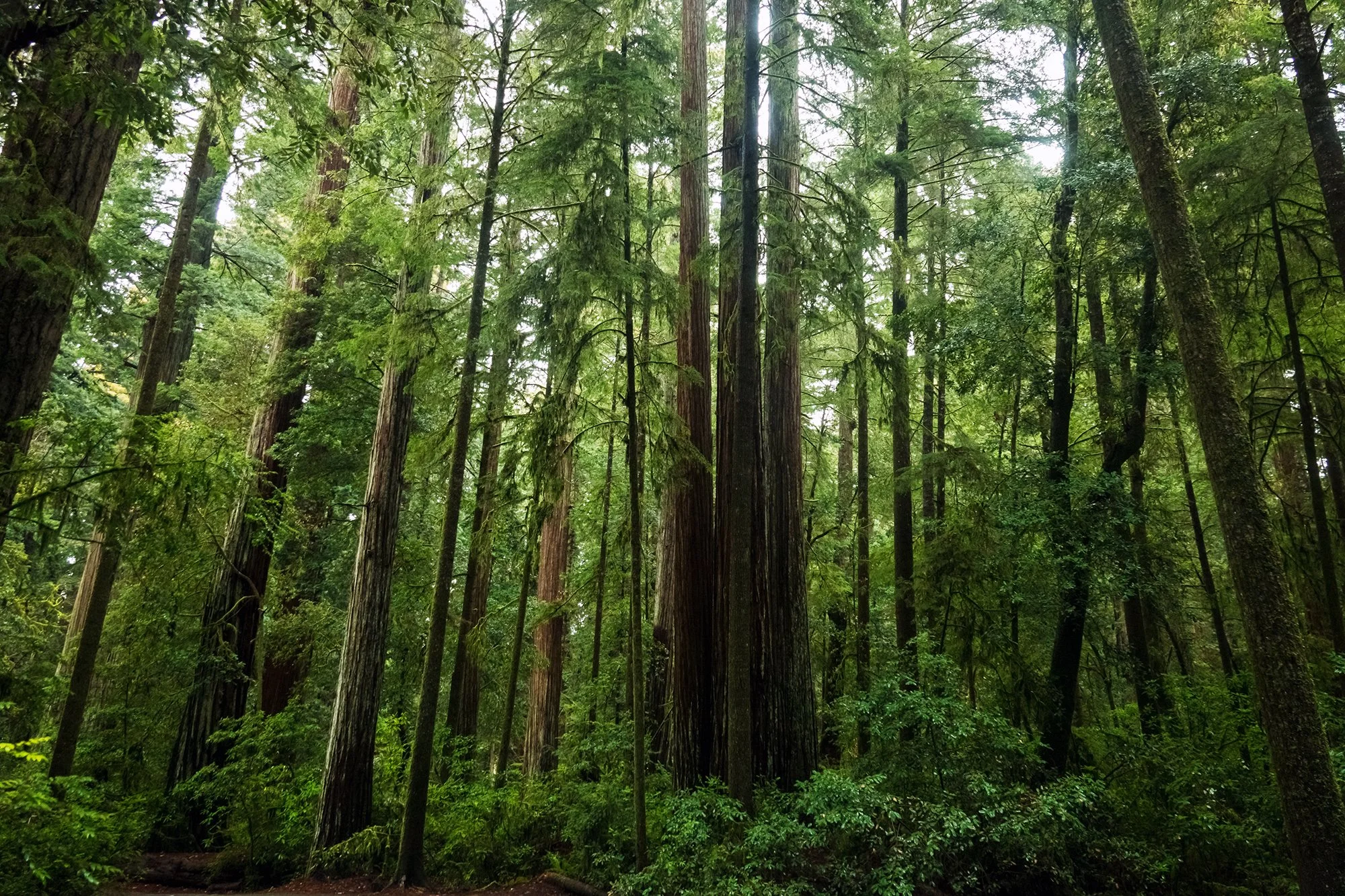
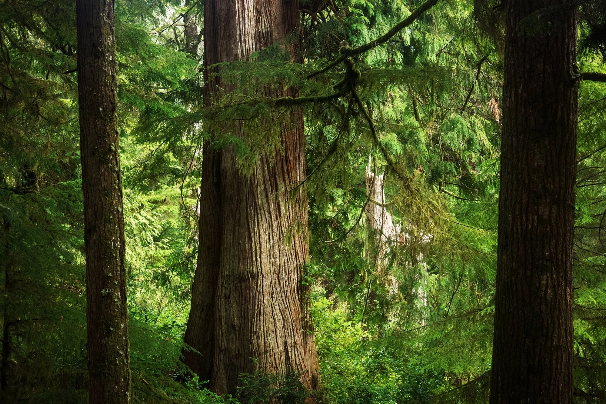
Back at the car, I move a short distance down the road to the trailhead at Elk Flats - an expanse of meadow flanked by the headlands of Cape Falcon and Neah-kah-nie Mountain. From here, it’s a short (muddy) jaunt to an overlook above the Devil’s Cauldron, a roiling cove pincered between two rocky seacliffs. Heading northward back toward Short Sand Beach, I walk a short distance into the forest, photographing the magnificent Sitka spruce forest here before returning to the car. The southward drive takes me past the towns of Manzanita and Nehalem; I pull off the road briefly at the marina in Wheeler, to watch the mist rolling in off Nehalem Bay. My next walk of the morning is a few miles south, on the outskirts of Rockaway Beach. Here, an ancient cedar swamp has been preserved in pristine, old-growth condition, and is home to one of the largest western redcedars in the entire state. I spend the next hour exploring the boardwalk here, photographing some of the bog plants (salal, beard lichen, Western skunk cabbage) in macro, and visiting the gigantic Great Cedar. Standing on a boardwalk at the edge of the bog, it is all but impossible to really capture on camera the experience of standing beneath this ancient behemoth tree; I give up and simply photograph the base of its trunk, with the boardwalk encircling it for context and scale.

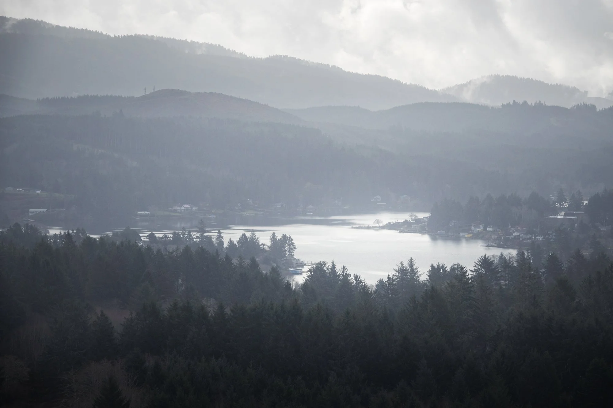
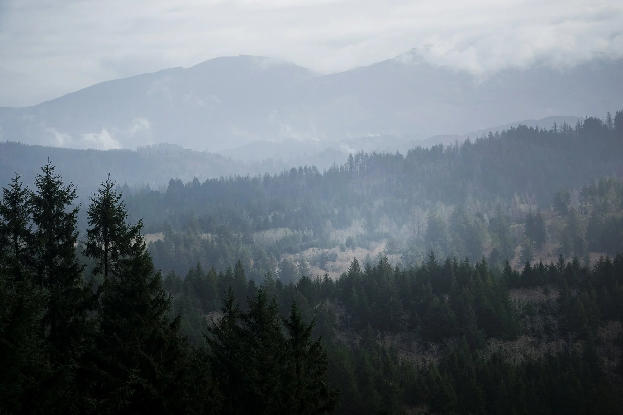
A longer drive now, south past Garibaldi and slightly inland through the city of Tillamook (with its famous creamery, its industrial grunge, and the re-appearance, for the first time all day, of traffic signals). I turn back out toward the coast, headed to Cape Meares. In the community of Oceanside, overlooking waves crashing upon the beach, I have an absolutely delectable basket of fish-and-chips at family-run Blue Agate Cafe before they close for the afternoon (it’s not only Sunday, but also Super Bowl Sunday). The proprietess brings me a bottle of malt vinegar to go with the fish-and-chips; a way better accompanimnent than the usual ketchup and tartar sauce.

After lunch, I continue onward to the tip of Cape Meares, where I walk down to the little lighthouse on the headland and visit the Octopus Tree, a massive Sitka spruce whose many tentacles reach skyward, possibly as a result of coppicing by Native Americans several hundred years ago. For me, the more interesting visuals at Cape Meares are seaward, toward the group of sea arches that lie offshore from the headland. In the passing clouds of mist and oceanic rain, I take telephoto of the distant rocks, which remind me of something out of the Faroes.

Finishing at Cape Meares, I retrace my route back to the south, taking the Three Capes Scenic Route which hews close the coast, running from Meares past Cape Lookout and ultimately toward Cape Kiwanda and Pacific City - my destination for the night. Before leaving Oceanside, though, I pause on the roadside to take a photo back toward the seaside houses perched below the headland, which, in the warm light of the passing afternoon, look so idyllic as to be quintessentially coastal Oregon. Gazing back at the houses and trees shrouded in mist, and the beachgoers walking below on the shore, I find myself feeling oddly nostalgic for a life I’ve never lived - warm days spent playing in the surf, lounging around the diner, heading up to the cape for sunset.

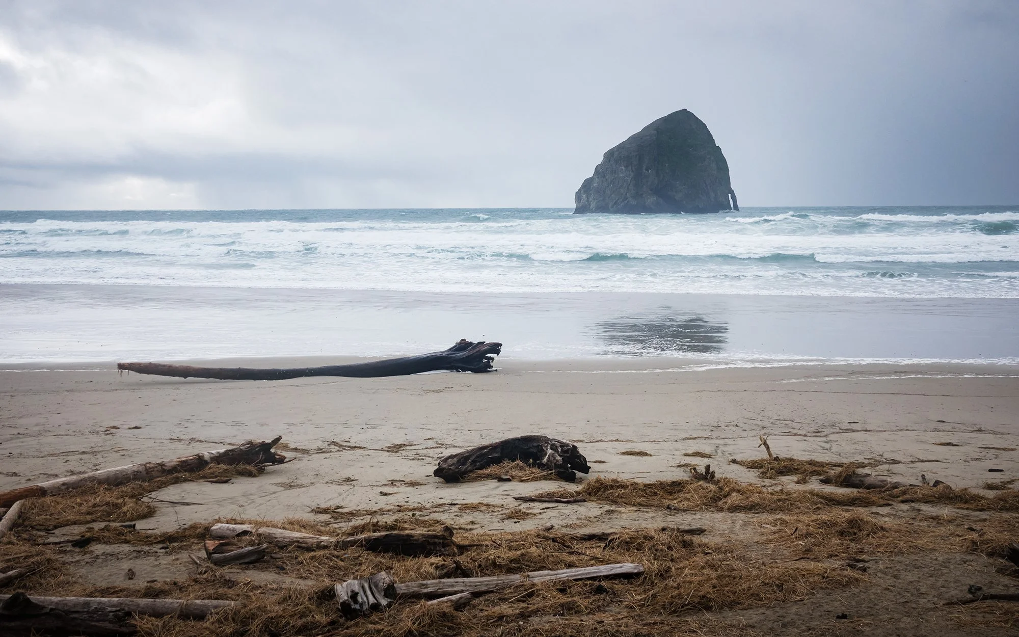
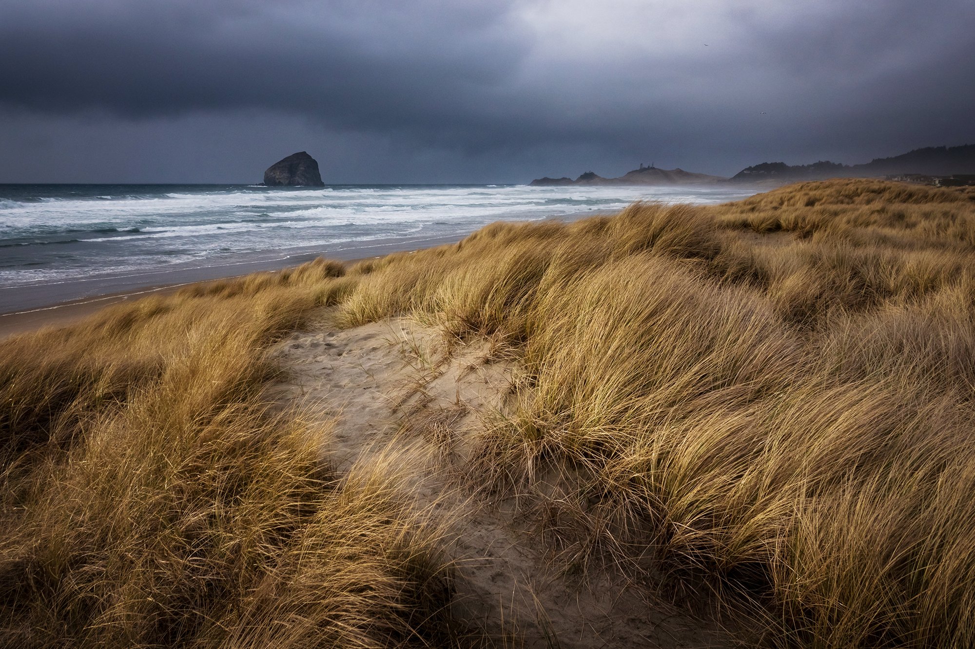
Due to a road closure along Sandlake Road, my drive to Pacific City winds up taking a long detour back to Highway 101, and I finally arrive at Cape Kiwanda around 4 PM. From the dirt parking lot at the beach, I can hear the Super Bowl underway at the bar next door; there are several families hanging out on the beach, tailgating and listening over radio. It’s been a long day for me, so I choose not to make the long walk and climb up the imposing sand dunes of Cape Kiwanda, instead opting to photograph up and down the beach.

The day’s last stop is a few minutes away at Bob Straub State Park, which encompasses a system of marshside and beachside trails along the Nestucca Sand Spit. I spend most of the sunset hour exploring along the dunes between the marsh and the open beach. The weather remains moody and changeable; in between gusts of wind and rain, there are some moments of brilliant sunset sidelight, which I take advantage of, shooting panoramas as well as low compositions in the dune grass. After a cold and rainy hour walking back and forth across the dunes, I decide to call it quits as the sun sinks into yet another thick marine layer. I check myself into a lovely room and kitchenette that night at the Surf & Sand Inn in Pacific City, where I hang my clothes up to dry and make dinner. After a long, hot shower, and a bit of scouting for the next day’s weather and routes, it’s off to bed.

Oregon: Central Coast

Day Three. I’m up early again after a restful night of sleep. It’s quiet outside; the motel parking lot is empty except for Blooty and a pickup truck, and the pitter-patter has finally stopped. I make myself a cup of tea, heat up my breakfast croissant sandwich, and get my things packed up and ready for the road. After sending Jane a text about where I’m headed, I set off on the highway shortly before dawn. In the dark of Monday morning, Pacific City feels completely deserted. I rejoin the highway and drive, southbound again, half an hour through the coastal foothills to Cascade Head and the mouth of the Salmon River, where Oregon’s Central Coast officially begins. Here, I’ll be leaving the car at Knight County Park and doing a two-mile climb through the rainforest to the top of Cascade Head. At the trailhead, there’s a warning about a cougar being spotted in this area recently, but the entire walk up and down, I spot no other mammals except for a herd of elk and a single trail runner. Hitching my backpack, I set off on a walkway that parallels Savage Road, passing some big properties and exclusive housing communities before reaching the (closed by landslide) upper trailhead, where a series of tree-root steps turns uphill into the forest. Aside from birdsong, the tinkling of a nearby creek, and the sound of wind whispering through the tall trees, the woods are quiet. I am alone with myself, my footfall, my thoughts.

I’m only three days in, but doing this trip solo has been turned out to be surprisingly rejuvenating and enjoyable. I had some apprehension before setting out, about being alone for the better part of a week, driving five hundred miles through Oregon and California, and walking through forest wilderness and atop tall sea cliffs without a companion. As I hike along and reflect back, I realize that while I haven’t formally done it in awhile, solo travel is something I’m quite comfortable with, after my experiences in the West when I was younger, and an entire summer traipsing around Jalisco during college. It’s been over a decade since I’ve been on my own (basically since moving in with Jane after college), but I’ve still retained my capacity for (and love for) being alone and getting lost in my thoughts - on sunrise trips in Maryland, and in my ranging outings on foot around Baltimore and Brookline. Traveling, hiking, and photographing on my own, I have the luxury of setting my own pace, stopping whenever and wherever I want to set up a shot (no matter how ridiculous the setup or sketchy the execution), and really immersing myself in my surroundings. To be fair, I’ve been very fortunate to meet compatible partners in travel. You can’t bring just anybody into the wilds with you - you need, ideally, someone who shares at least part of your appreciation for the world, who has learned how to respect beautiful places, who won’t muck up the mood with endless complaints, or feel the need to fill the void with unnecessary words. Still, there’s nothing quite like being on my own. In the early morning’s blue light, I make quick time up the hillside, resolving not to take out my camera until I reach the open views of Cascade Head.

Toward the top of the preserve, the forest opens up onto a grassy promontory carpeted in stonecrop and fescue. Up ahead, Cascade Head rises out of the cliffs - an ancient, extinct volcano uplifted from the ocean. The going here is wet and muddy from the prior day’s rain; I have to watch my footing to keep from slipping on the narrow path, which seems to slide a few inches downhill with every stray step. I stop near the tip of the promontory, where the dirt path swings back up the hill toward a higher viewpoint; not wanting to risk a steep and muddy descent in my worn-out, cheap Redhead boots (which I’ve been wearing since the Adirondacks, in fall 2019), I choose to stop my hike here and take in the surroundings. To the south, the estuary of the Salmon River curves around God’s Thumb, the eroded prominence on the next headland; beyond, a line of breakers falling on the beach in front of Lincoln City. Inland, to the east, mist is rising from the valleys between the foothills and peaks of the Coast Range. With my shutter speed dialed up fast, I take some ultra-telephoto exposures of the mist and distant trees with my 600mm zoom lens -a magical, moody scene quite emblematic of my time on Oregon thus far. I take a variety of compositions and panoramas before taking a water break and heading back downhill. Along the way, returning through the forest as morning light appears beyond the canopy, I take my time photographing the preserve’s marvelous stands of old-growth spruces and hemlocks, Douglas firs and red alders. Everywhere, the trees are draped in moss, hanging strands of lichen, and broad, low fans of shield fern that grow on living branches and nurse logs alike. The forest is so wonderfully old and serene, like no other place I have ever walked before.

Back at the car after a breezy walk (four miles total), I drive a short distance south toward Lincoln City. In the hills overlooking the town, I leave the car at a dead-end trailhead and set out for a loop hike circling the Knoll Open Space, an area of old woodland and pine farm encircling the Knoll, a open meadow that rises above the seaside town. The first mile of the hike is on pavement, walking through the suburbs of Lincoln City and up to the Knoll itself, where I find lofty views of the Pacific Ocean to the west, Devils Lake to the south, and the Coast Range to the east. From this viewpoint, I debate returning back to the car (the devil I know, but oh-so-boring trekking through suburbia) or completing the entire loop, and decide, unfortunately, to do the latter because I have plenty of time. On the backside of the loop, the trail initially passes through lovely groves of spruce trees, but it soon descends steeply into a long, undulating section of forestry road. While not difficult or technical at all, the road is, frankly, so muddy that it is unpleasant - not just “there’s some water on the trail and your boots might get a little wet” but “it’s all mud, all the way down, and you’re going downhill with no traction.” I take my time and make it back to the car shortly after noon, quite happy to have not had any slips and to be back on solid ground.

Headed south again, I re-enter civilization and grab a cheeseburger, fries, and root beer at Hwy 101 Burger in Lincoln City (an awesome little seaside joint with a pinball arcade in back and punk decor on the walls) before driving south toward my next destination of Yaquina Head. I pass by the beachfront boardwalks at Depoe Bay and Beverly Beach, stopping roadside to photograph Yaquina Head in the distance just before I enter Newport. Out on the headland, I park Blooty near the lighthouse and set off first up the Salal Hill trail, a short gravel path that switchbacks up the coastal sandstone hill overlooking the lighthouse. From the top, there are lovely views back toward the shoreline to the north and south; I photograph the winding road back along the headland, and Blooty looking even smaller than in real life, down below in the parking lot. After returning back down the hill, I check out the tide pools below the lighthouse (the tide is high and crashing on the rocks, so I stay far away from the beach) and circumambulate the lighthouse before continuing my drive south. After a stop for gas in Newport, it’s onward to Yachats and Cape Perpetua, where I’ll be spending the rest of the afternoon.

Past the settlement of Yachats, where I’ll be staying for the night, the highway hugs the cliffside as the land becomes more dramatic, rising sharply out of the ocean in a deep series of coastal peaks. Here, the landscape is a study of contrasts: wave-dashed inlets and tidepools on the shore, and less than a mile inland, mist-strewn valleys where massive tracts of coastal rainforest dwell, not unlike along the rocky shoreline of Big Sur in California. My main stop here is the Cape Perpetua Scenic Area, where I drop into the visitor center and purchase my trip magnet before setting off on a short hike to an old, giant Sitka spruce tree, reputed to be over five hundred years old. The trail to the massive tree parallels the park’s campground (deserted for the season), which I can see through the trees just on the other side of the gentle creek that runs down the length of the valley. A mile in, after a detour through the far end of the campground, I come to the Giant Spruce, a startling specimen of a tree, not the least for the massive hollow at the base of its trunk (created after the nurse log that the spruce grew from eventually decayed). I walk around the trunk and look up toward its soaring crown; unable to help myself, I break out the tripod and take some panoramic selfies with giant tree; given the confines of the forest, stitching multiple exposures together is the only way I can really capture the size of the majestic spruce. To mix things up on the return, I choose to walk along the road through the campground; the peaceful atmosphere of the empty campsites, with the adjoining stream and the tall forest on either side, is quite magical itself.

It’s late afternoon when I return to the car. I head a short distance down the road to watch the waves at Cave Cove. The swell coming off the ocean is massive, sending towering walls of water crashing down Cook Inlet and erupting from Spouting Horn and Thor’s Well. I dialed in a fast shutter speed and take some action photos of the breaking waves in the light of the setting sun. Finally, for sunset, I drive back up the road to Cape Perpetua Lookout, a high viewpoint atop the headland itself. Here, a short trail leads through the whispering spruce trees, where it opens up to an impressive vista of the Pacific Ocean and the winding coastline below. I spend the golden hour here, sitting silently in the old stone shelter at the tip of the headland (where, surprisingly, I have cell coverage, and exchange a few words with Jane to close to day). As I take in the beautiful views of the Central Coast and the inland mountains, the sun fades into yet another bank of offshore clouds. Dark approaches, and I make my way back down the mountain and back a few miles to Yachats, where I check into a single room at the Dublin House Motel that is the very definition of cromulent. After dinner and a shower, it’s off to bed.

Oregon: South Coast and Deep Forest

Day Four. As morning approaches, the air outside is still, and a coastal fog lingers over the hillsides above Yachats. The little faux-lighthouse in the motel’s parking lot looks quite fitting for the early dawn light. I’m blessed with another day of beautiful clear skies as I journey from Oregon’s mid-coast to the coastal terminus of my trip, the town of Brookings near its southern border. To take advantage of the good weather window (tomorrow it’ll be again pouring rain along the South Coast), I re-arrange my itinerary and cut out a hike at Siltcoos Lake in order to spend more time this afternoon in the Samuel Boardman Scenic Corridor, where I know there’ll be a series of beautiful trails and viewpoints to explore. At seven o’clock, I set out from Yachats and drive twenty minutes to the south, to my sunrise destination - the lighthouse on Heceta Head. Aside from a single other campervan, I’m the only person visiting the beach at this early hour. I walk up the paved pathway toward the lighthouse, which passes the old lighthouse keeper’s house (now a bed-and-breakfast) and features beautiful views of the stacks and promontories to the south, as well as lovely views back toward the rising sun and the Cape Creek Bridge, which resembles an old Roman aqueduct spanning the forested hillsides. On Heceta Head, I climb the trail behind the lighthouse to grab a panoramic composition of the light with the coastline and sunrise behind. I stay here awhile, admiring the old lighthouse tower’s picturesque location at the edge of the sea, before returning to the car.

Back on the road for a long drive to the south. After crossing Cape Creek Bridge, I stop for a roadside overlook of Heceta Head behind me, and another stop as the Oregon Coast Highway descends the headlands toward Florence. Below me, the scenery opens up, revealing a long stretch of open coastal plains fronted by sand dunes and beaches. I take some photos of this scene, as well as of the blooming bushes of gorse that lie scattered across the hillside. Passing through the town of Florence, the highway continues back into forest, gaining elevation as it enters the Siltcoos area, a region of spruce and fir forests interspersed by the curling, dendritic arms of several freshwater lakes. There are lovely views to the east, of morning mist gathering over the waterways and trees below me, but I pass them by without finding any suitable place to stop on the winding, mountainous highway. After several miles, another descent - this time into the towns of Gardiner and Reedsport, on either side of the Umpqua River. Another few minutes later, I turn into the campground for the Umpqua River Lighthouse State Park, where I’ll be completing my second walk a day - a short, 1-mile loop around Lake Marie.

Not content to only photograph seascapes and coastal scenes, I wanted to include at least one classic forest-and-freshwater location on my trip. I park the car beside the campground and set off walking on the even, easy dirt path that circles the lake. It’s a beautiful place, and peaceful - almost too peaceful. Perhaps it’s the eerie silence (I note an almost total lack of birdsong, and even a scarcity of wind or ambient sounds), or perhaps it’s the long-outdated notice about a cougar having been spotted in the vicinity several months ago, but I can’t help but feel uneasy as I circle the lake by myself. I wind up power-walking the whole thing, save a few stops to photograph the interplay between light and shadow in the trees, and out on the surface of the lake. One mile and a half-hour later, I head up the road to glance at the Umpqua River Lighthouse, which is teeny-tiny and quite cute; I choose not to photograph it (honestly, photographing lighthouses tends to be extremely boring for me, as I alluded to when Jane and I visited Cape Cod in 2020). From there, it’s back to the highway, headed south to Coos Bay for a late-morning grocery run at the local Walmart and an early lunch at the adjoining Arby’s. Stocked back up with my final few days’ worth of canned vegetables, roast beef sandwiches, fruit smoothies, and decongestants (I have developed some lingering cold symptoms, courtesy of baby, and am in no mood to suffer plane-related ear barotrauma on the return flight in a few days), I leave the city behind and start the hour-plus drive southward to the southernmost stretch of the Oregon Coast.

In the early afternoon, having passed by the town of Bandon and made good time cruising down the coast on the highway, I reach Sisters Rock State Park, named for the trio of rocks (two paired on either side of a long, grassy promontory, and the third a sea stack just offshore). Here, the skies are absolutely perfect on this February afternoon, and the water shimmers in brilliant hues of turquoise and aquamarine. From the trailhead, the coast stretches away to the north and south: to the north, a landscape of wind-blown bluffs and rugged cliffs heading out along Cape Blanco, under the watchful gaze of Humbug Mountain; and to the south, an array of dark rock stacks nestled in the protected cove in front of Frankport Beach. I set off on the gravel path that descends along the promontory, ultimately leading to the two of the Sisters - one, a tall, imposing climb along an eroded grass path, and the other, a rocky trail that leads to a sea cave. I climb down and up to the mouth of the cave, from which the boom of the waves echoes every few seconds; at the gullet, I sit for awhile and watch the roiling waves crashing in the dark bowels of the island below. Terrifying, and beautiful. The landscape of grass and basalt, and the wildness of the interface between land and sea, make me feel again as if I’ve been transported to someplace in Iceland, or the Faroe Islands. After a steep climb back to the highway, I resume my course south, shortly passing through the settlement of Gold Beach and then stopping for a quick walk at Meyers Creek Beach, where another group of massive stacks is poking out of the ocean at high tide. In a beautiful moment of serendipity, Sufjan Stevens sings “…fumbling by Rogue River” (Mystery of Love) right as I cross over the road bridge at the mouth of the Rogue. The moody playlist has really elevated this trip, accentuating all my feelings of joy and introspection and solitude.

A little further south, I enter the famous stretch of the Oregon Coast known as the Samuel H. Boardman Scenic Corridor. Here, the coastline again evolves into a jumble of sea cliffs, secluded rocky beaches, and coves dotted with picturesque, pine-covered islands. There are a number of fine trails and iconic viewpoints in this 12-mile stretch of the coast, and I had planned to spend the entire following day exploring them, but have modified my plans to do as much as I can during what remains of this afternoon, given the oncoming atmospheric rainstorm which is set to hit the coast tonight. I stop for brief photo ops at the Arch Rock and Spruce Island Viewpoints, before driving south to the Indian Sands trailhead for a mid-afternoon hike. Here, the trail descends sharply through a forest of shore pines, to an open area of unstructured sand dunes and towering sea cliffs. It’s surprisingly hard walking, and the trail is not particularly marked, with desire paths everywhere, as evidenced by footsteps that tramp all over the dunes in every which direction. After viewing a natural sea arch to the north, I swing around the headland, following the dunes around, down, and up a sandy bowl. All around, the evidence of cataclysmic erosion is present, from the meandering lines of old creek beds, to a blasted chunk of fallen sandstone (right below the cliff where I am standing, I note with some concern as I cautiously inch away from the edge). On the far side of the bowl, I am greeted by a another viewpoint of the islands and sandstone capes to the north; I continue here up a grassy path on the cliff’s edge, which crosses a trailside creek and then emerges back in the forest, near the highway. Another few hundred yards, and I emerge back at the trailhead, at the opposite end of the parking lot.

From here, I take a brief drive south to see the rest of the Boardman area, stopping at the Whaleshead viewpoint (from which I take a long telephoto shot of houses back up the coast), and scouting out Cape Ferrello and Lone Ranch Beach (where I photograph the beach as well as the clusters of baneberries and periwinkles that line the path). Then, I return north to the Natural Bridges area, where I will be taking my final walk of the day and enjoying sunset. From the north side of the trailhead, I take a path that descends steeply through the forest toward Thunder Cove and a view of North Island. The sun is sinking lower now, and the shimmering, golden light looks quite lovely coming through the trees. Back at the trailhead, I camp out at the nearby viewpoint overlooking several pine-topped sea arches. There are several lower approaches that lead to famous viewpoints of these arches, as well as a (strictly off-limits and rather eroded) path to actually climb atop some of the arches, but both because I am traveling solo, and because I have a general distaste for causing environmental impact just to gather Instagram-famous compositions, I keep to the viewpoint by the road as sunset approaches. Regardless of it all, it’s a lovely one - the fading sun lighting the stacks and arches below in a warm, golden light; the crash of the waves upon rock; and the sigh of the sea wind moving through pines. It’s a beautiful way to end my long day on the coast. After dark, I drive into town and check into the Americoast Inn at Brookings, where I’ll be staying for two nights. After a lengthy shower and a fine motel room dinner (roast beef sandwiches, ramen with vegetables, fruit, and a drink), I pop on the TV for background ambiance and try to figure out what I want to do tomorrow, given a general reluctance to re-visit the Boardman Corridor and its steep, eroded trails during what appears to be incoming gale-force winds and rains. After scrolling around the map for awhile, I come up with a spontaneous idea that makes me feel quite satisfied; I tuck into bed with the plan to sleep in later than usual before checking road and weather conditions across the California state line.


Day Five. In the morning, a bona-fide storm is raging outside and I skip sunrise, as planned (although this involves getting up and taking some time to fall back asleep, thanks to jetlag). After breakfast (more sandwiches, more fruit, more juice), I call the Redwoods National/State Park office in California to inquire about driving conditions. The ranger seems totally nonplussed, and reassures me that Blooty will be just fine where I’m planning on going. After filling up the tank in Brookings, I make a forty-five minute drive southward in slashing rains and driving winds, passing the California border, and turning east along the banks of the Smith River. Past the settlement of Hiouchi, I cross over the Nels Christiensen Bridge and head into Jedediah Smith Redwoods State Park along Howland Hill Road, a well-maintained gravel path that winds around and between massive trunks of coastal redwoods. I plan to stop at two trailheads in the park (at the Stout Grove and the Mills River Trail) before returning to Brookings to explore a third redwood grove in the Rogue-Siskiyou National Forest.

To be clear, I have already seen my share of beautiful old-growth forests and massive, majestic trees during this weeklong trip down the coast. However, this day spent among the redwoods achieves, in my mind, a different level of majesty - something approaching the sacred. As I wind through the enormous trees at the Stout Memorial Grove, it feels like I have made a pilgrimage to a truly special place - nature’s cathedral at Chartres, holy in its construction, unique in all the universe. The towering canopy and the vastness of the the individual trunks feels impossible to convey - almost meaningless to convey - on camera. The rain is coming down hard, misting down into the understory and totally soaking me and the camera despite my best attempts to utilize my rain gear. I become keenly aware that I am not sure how much what I am feeling is rain streaked across my face, and how much is tears of happiness. I sit in the grove for awhile, watching the rain coming down over everything, and feeling incredible light surging up through my body and into the old forest.

After walking out to banks of the Smith River and circling the grove once again, I return to the car and continue down Howland Hill Road, to the trailhead for the Mill Creek Trail. Here, I follow the forest trail as it winds uphill through stands of spruce and cedar before emerging into a special part of the woods known to the area’s former indigenous tribes (the Tolowa and the Yurok) as the Deep Forest. The trail here has to be one of the most memorable paths I’ve ever walked in my life. At one point, it emerges into a view of a massive fallen redwood, a three-hundred foot-long nurse log strewn across the edge of a grove; just as I begin to wonder how I will possibly get across the log, I notice that the trail actually descends under the log, paralleling it like a natural forest tunnel. For as long as I live, I will never forget the experience of creeping under and alongside the length of a fallen coastal redwood, shimmying beside it, feeling its bark and life-giving structure with my bare hands. On the far side of the log, the trail passes through a clearing and then re-ascends into the redwoods, entering the Deep Forest. The Grove of the Titans, a group of especially gargantuan trees, is only a few hundred yards further along. I have a hard time photographing this scene, in part because of the trees’ unfathomable scale, and in part because my camera LCD is beginning to short-circuit thanks to several hours of constant soaking from the rain. The camera troubles might normally become a source of intense anxiety or frustration during a photo trip, but I find that they barely affect me, so high are my spirits. I do as best as I can shooting with only the optical viewfinder, before putting the camera back into my pack and focusing my energy on being present in the forest. The photos, technically limited as they are by rain damage and moisture condensing on the lens, are still quite breathtaking when I am finally able to view them later that day from the comfort (and dryness) of the motel.

Back at the car, I retrace my steps, leaving the California redwoods behind. I stop briefly at the road bridge to photograph the turquoise Smith River in the mist-laden gorge below, before making the long drive back to the vicinity of Brookings. For my last stop of the day, I turn off inland along the Chetco River, to take a brief walk at the Alfred Loeb State Park, within the Rogue River-Siskiyou Forest and at the edge of the rugged region known as the Kalmiopsis Wilderness (after a rare rhododendron-related plant that grows solely in the area). It is mid-day now, but the rain has not abated; it comes down in great heaving sheets as I drive the car along the winding riverside road. From the trailhead, where I am once again alone, I set off on the Redwood Nature Trail, a mile-long loop uphill and down again across a series of creek falls and through an old-growth redwood forest - less monumental than the ones earlier in the morning, to be sure, but no less beautiful. My camera LCD is now glitching out erratically as if having a grand mal seizure; I still risk a few shots using only the viewfinder while praying that the moisture won’t permanently damage the internal electronics - or worse, the memory card. After a lovely but soaked jaunt through the trees, I take the final shots of the trip as I descend back toward the car: a view of the distant wilderness, the background peaks fringed with low-lying clouds and mist, the foreground fronted by evergreens and trunks in silhouette.

Back in town, it’s time for an obligatory visit to the combination KFC/Taco Bell for lunch (I get a 3-piece meal: amazing after a cold and rainy morning, but after all those years in Baltimore, I can no longer have KFC without reflexively thinking it doesn’t hold a candle to Popeyes), then back to the motel to wring the rainwater out of everything in my present life, including my socks, boots, hiking clothes, backpack, tripod, and camera. I spend the rest of the rainy afternoon relaxing, drying off equipment, and getting things repacked for my return to Boston. As evening approaches, I am tempted to sally out again by a slight break in the seaward clouds, but then I remember my camera (on life support), my gear (damp as hell), and the condition of the local sea cliff-top trails (probably a mudslick deathtrap) and think better of it. In an ultimate act of care for my future self, I call the rental car company and negotiate a later return time on my car (at no extra charge!), and have a lovely time sleeping in the next morning.

On Thursday, it’s a rainy, long, four-hour drive from Brookings to Medford via the California state border, Cave Junction, and Grants Pass (thanks to road repairs and a nearly hour-long delay on the Redwood Highway). After lunch at In ‘n Out in Medford, a final refuel, and returning my car at the airport, I board my late afternoon flight to Seattle, transferring after an airport dinner to a overnight red-eye to Boston. Slight case of airplane ear notwithstanding, I am excited to be home the next morning by the time Jordan wakes up, and feeling rejuvenated and ready to rejoin family life after an incredible week on my own, attending to and capturing a beautiful region on camera, and communing with the natural world in some of the most awe-inspiring places I’ve visited.