Day 3: Skye I

It's chilly when we awaken the next day.  The electric fireplace has been running through the night, and the condensation on the window is glowing with the early morning sun coming up over the sheep pastures. Downstairs, Donna has laid out a spread of toast, fruit, and yogurt at the dining table in the living room, and she prepares a hearty breakfast of grilled mushrooms, tomatoes, freshly farmed eggs, and grilled shoulder bacon. Bessie runs in and out of the room, checking on our progress as attentively as a fancy restaurant waiter, while the cat sits stoically a few inches away from a space heater next to the fireplace.  Donna comes over to chat with us, and is understandably disappointed that our whirlwind itinerary is taking us out of Glenelg and over the water to Skye. She suggests that we at least drive down the road to Glen Beag, to see two of the largest and best-preserved brochs (Iron Age stone dwellings) on the Scottish mainland, before catching the ferry from Glenelg to Kylerhea.  She and her husband were married inside one of the brochs, so fond were they of its history and stately charm; she shows us an album of photos from her wedding day.

We take her up on her advice.  Continuing east on the single-track road south of the village, we drive along another valley lined by pastures, pine forests, and a single feathery waterfall. We stop to watch the flocks of sheep with their new spring lambs (photo below), who ram their wooly heads into one another and skip awkwardly after their mothers. The herd suddenly takes off running along the fence, chasing after a pickup truck headed in the opposite direction. The driver hops out and pulls a big bag of feed from the truck bed. Breakfast.

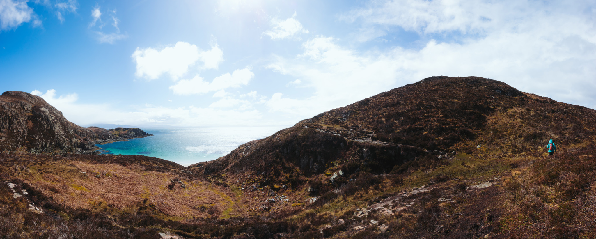
At Dun Telve, we unlatch the sheep gate and walk in along the fence, admiring the circular, drystone tower. It is perhaps 30 feet tall and hollow, with walls several feet thick in some places. We walk into its center and look up, seeing little stone ledges - remains of a staircase, or perhaps room partitions. It is uncertain what structures like these, dating back several thousand years and built by the Pictish tribes, were used for - perhaps defensive structures, watchtowers, or high-class residences. A formidable chunk of human history sitting in a idyllic little valley on the Scottish coast.

After seeing the brochs, we drive back through the village and north to the ferry crossing, where the a hand-cranked turntable ferry - the Glenachulish, the last of its kind in the world - still shuttles passengers back and forth across the narrow strait to Skye on the half-hour in the warmer months. Dating back to the 1600s and previously the one true route "over the sea to Skye", the Kylerhea ferry came upon leaner times with the opening of the Skye Bridge in 1995, and is now community-owned and operated - another piece of living Scottish history for our morning. We watch at the dock as the boat pulls in, its wooden deck spinning steadily into position. I drive Diesel onto the boat. On board, Jane and I hop out of the car, savoring the breeze for the entire five-minute ride across the water. It is not how I envisioned reaching Skye ten years ago, but Donna was absolutely right: there is something magical about doing it the old way.

Across the water, we drive through the little village of Kylerhea and turn uphill to reach the car park for the wildlife sanctuary. We walk in, less than a mile through the pine woods on an easy gravel path, to an indoor hide that is popular with locals as a whale and porpoise and otter-watching spot. Binoculars to our faces, we watch the grey seals swimming around the rocks on the beach below, while the Glenachulish and its boat horn make their laps across the narrows.

Leaving Kylerhea and Skye's eastern coast, I drive us along the twisting, single-lane canyon road over the Kylerhea River. Jane falls asleep. After twenty minutes, we re-join the A87 and head west toward Broadford, pulling into the parking lot of the Skye Co-op in Broadford around noon. I wake Jane from her slumber ("Lunch. Pastries." "...Huh? Okay.") and we head into the grocery store and bakery, where we discover the wonders of the Portuguese egg tart, from which the Hong Kong egg tart (蛋撻; dàn tǎ) was derived. It is virtually identical to the dim sum dessert that I grew up loving, except that the top is generously carmelized, and it is available here and now, to two young Chinese-Americans vacationing on the Isle of Skye, for less than a dollar a pop. We buy out the bakery's stock (along with our usual sandwiches and drinks) and throw it in the car. Heading west on the island, we stop at the old stone bridge in the settlement of Sligachan before continuing on to Glenbrittle at the foot of the Skye's most imperious mountain range - the Black Cuilins.

From the busy car park at Glenbrittle, we set off on the footpath into the valley and toward the mountains. Walking east along the River Brittle, we hop over stones and waterfalls, passing alongside crystal-clear pools of blue and turquoise water, runoff from the heart of the Cuilins. As we continue, the waterfalls grow taller and the other day-trippers climbing the rocks and sunning by the pools become more sparse, while the mountains ahead grow taller and ever-more-imposing. The clear dirt path soon degenerates into a rough peat track across the heather moor. We continue to climb into the foothills.

At the foot of the Black Cuilins, we find ourselves in an amphitheater of mountains: Bruach na Frithe ("Slope of the Deer Forest") to our left,  Sgurr Thuilm ("Peak of the Hillock") to our right, and straight ahead, Sgurr an Fheadain ("Peak of the Chanter"), a pyramidal block of gabbro bisected by a deep cleft (Waterpipe Gully, one of the more technical rock climbs in the country). We scramble partway up the loose rock scree that leads into the mountains, and reach the entrance to Coire na Creiche ("Corrie of the Spoils"), the mountain cirque where the MacDonalds climactically defeated the remnants of Clan MacLeod in 1601, in the last such battle on Skye.

Turning away from the stream, we head north now, following the flanks of Bruach na Frithe toward Sligachan.  The way is muddy; in hindsight, we likely lost the walking path soon after reaching the corrie, and wind up following a less-beaten trail across the moor. Boots squishing in the mud, we peer ahead into the endless expanse of peat bog, trying to discern any signs of a path - a flattened patch of grass, an opening in the heather, a few scattered footsteps in the mud. There are no other humans for miles around, and it is mid-afternoon. Alone in a massive landscape, and acutely aware of the caprices of mountain weather, a very mild worry sets in. Jane suggests bee-lining across the moor back toward our car (we can still see the edge of the forest near the car park), but we are on the wrong side of the River Brittle, and the undulating landscape guarantees us running into some nasty terrain. We continue picking our steps across the slope, jumping up and down terraces of peat in order to find the least muddy way forward. At intervals, there is a small boulder beside our path; Jane hops on one to get a better look at our surroundings. At first I think they are just glacial erratics cast off from the mountain, but after awhile it becomes clear that they are trail markers, quite deliberately spaced. We are on a path, if not the right one.

After an hour of following boulders and vague intuition across the moor, we are vindicated by the sighting of another path up ahead, cutting east-to-west between Sligachan and Glenbrittle. We hop over one last pit of mud and scramble up the side of a waterfall, emerging gratefully onto a well-trodden gravel path. Turning left here, we walk along the other side of the river, passing around the edge of a forestry zone to connect back up with our original path. We return to the Glenbrittle car park around 4 PM, concluding an unexpectedly eventful six miles of walking in the south of Skye. Jane briefly takes over the driver's seat while I eat a Portuguese egg tart with a box of pineapple juice and half of a leftover sandwich.

Leaving Glen Brittle and the Cuilins behind, we drive north now along the west coast of Skye, taking the A863 toward Dunvegan. On a peninsula near Carbost, we get a magnificent view of the Atlantic Ocean and the minor islands to our west, glimmering under the afternoon sun. We continue, passing by villages, cottages, and little crofting communities. Near Bracadale we stop in a car park, and climb up a hill covered in sheep and little pellets of sheep dung. We arrive at the broch of Dun Beag, a massive stone fortification quite similar to the ones near Glenelg. Jane climbs to the top of the tower ruins and gazes out across the west of Skye, north to the Duirinish Peninsula and the pair of prominent mesas known as MacLeod's Tables. To our south is an open, gorgeous view back to the Minginish Peninsula and the Cuilins; the mountains continue to appear raw and imposing, even in the distance. As the sun begins to fall toward the horizon, we set off again toward our last stop of the day.

Just before Dunvegan, we turn west off the A863 onto a one-lane road the crosses the Duirinish Peninsula. We pass the villages of Colbost and Glendale (Jane is asleep again), and the road becomes somewhat more narrow and harrowing as the countryside gives way to sea cliffs and rocky Hebridean coastline. Near sunset, we arrive at the westernmost tip of Skye, a finger of rock pointing west across the Minch to the isles of Uist, Harris, and Lewis. We descend the cliff from the car park and walk across the headland toward the lighthouse on Neist Point. Jane stops to admire the colonies of gannets and black guillemots that inhabit the cliffs, breeding and nesting and artfully smearing their guano atop the pillars of hexagonal basalt. As the day ends, we take portraits together on the edge of a cliff near the lighthouse, the sea birds crying and flying through the air around us. In the distance, the Outer Hebrides are silhouetted by the setting sun, and I am reminded of the book Sea Room by Adam Nicolson, a Cambridge-educated author who, through a twist of fate, ends up owning the Shiants, a tiny set of Scottish isles somewhere out there in the Minch. His book, half family memoir and half work of love for his islands' geography, geology, flora, fauna, and human history, is what stays with me as I take the photos below, with the wind whipping and the sea birds flying overhead.

The sun has nearly reached the horizon when we return to the car park and drive back across the peninsula (the single lane road across the sea cliffs is no less harrowing in the diminishing light and with Jane awake). We finally return to the highway (it is around 8 PM at that time) and set off past Dunvegan and east across Skye at a blistering pace. The roads are nearly empty now, and despite the long day and the late hour, what follows is the best thirty minutes of driving in my life -  flying across the moors of central Skye,  wind turbines and farming villages all around us. The sky turns pink and then purple, and the open plains glow golden in the last bits of daylight. It is nearly dark when we reach the little settlement of Borve, on the outskirts of Portree (the large fishing town on the east coast of Skye). Our host for the night, Dougie at the Eubhal House, comes out to greet us as we pull into his driveway, a little gravel road next to a tractor behind a farm shed. He has been worried about us, and we apologize for our unexpectedly late arrival (we later realize that he emailed multiple times earlier in the evening, probably concerned that we were lost or had canceled our trip). Dougie shows us to our room, where we fill out breakfast cards and munch on our standard road dinner - sandwiches, juice, Scotch pies, and dessert pastries. Sitting in our country house, I gaze out the bedroom window, at the vast expanse of island landscape receding into the darkness. A truly memorable first day on Skye.

Day 4: Skye II

I am sitting by the windowsill again the next morning. Jane is snoring, and I am watching the empty moorlands and distant hills turn gradually blue, then white and gold. We walk out to the conservatory of the Eubhal House, where a breakfast spread has been laid out beneath the glass ceilings. Dougie and his wife Anne bring us fresh pots of tea and coffee, and we help ourselves to juice, milk, and toast with homemade berry jams. We sip on our drinks while the sun rises over the island. Off in the yard behind the house, a family of red-tailed deer goes bounding up the hillside. "Ooh, look at 'em go!" Dougie yells as he brings in our plates of scrambled eggs, bacon and sausage, black pudding, grilled tomatoes, beans, and potato scones.  A bushy-tailed forest cat appears at the back door to the conservatory; he paws and paws at the glass, trying to get our attention. "Wee feller's cold this mornin'!" Dougie says with a laugh. "That's our Smokey." Jane lets Smokey in, and he saunters off to sit in the living room. After breakfast, Dougie pulls out his road map of Skye and points out places for us to see on the Trotternish Peninsula, along our driving route to our north. He is pleased that I've read about Flora MacDonald and the Bonnie Prince Charlie ("Full marks for ya, laddie! Studyin' before travelin', that's what we like to see!"). We bid him farewell for the day, and set off with our heavy jackets and hiking packs in tow.

We drive east, through the harbor town of Portree, and continue north along the east coast of Skye. Fifteen minutes later, just north of Loch Leathan, we pull off into a car park under the Storr, a hill of volcanic rock overlooking the Sound of Raasay to the east. The wind is howling furiously as we get out of the car; after several days of relatively mild if unpredictable weather, we are finally due for a full blast of the highland climes. Leaving the car park, we pass through a series of sheep gates and begin climbing a well-paved forestry track through (yet another) recently felled area. My trail guide, borrowed from Dougie's collection and perhaps a bit outdated, describes "a lovely walk through forest." Instead of this, we climb bleakly toward the mountain ridge in the distance, the barren hillside offering little protection against the strong northern winds.

At the top of the forestry track, about one mile in, we pass another sheep fence and begin climbing the stone steps up toward the Sanctuary, an area of bizarre rock formations at the foot of the Storr. The Storr itself is merely a prominent section of the Trotternish Ridge, a geologic formation that extends like a spine down the center of Skye's entire northern peninsula.  The ridge was formed by a series of massive landslips - layers of sedimentary rock tipped vertically and then toppled over by the weight of dense volcanic basalt.  Millions of years ago, a black wasteland covered by ancient lava flows;  thousands of years ago, scratched and clawed by ice; now, merely a collection of stunning landscapes, covered by yellow-brown heather and clear-cut stumps. The wind is pounding away at our exposed faces as we climb toward the most prominent basalt pinnacle - the Old Man of Storr. We pull our winter hoods over our heads and trudge upward, step by step, yelling vague, inaudible instructions to each other through the wind. In the heart of the Sanctuary, ever so slightly sheltered from the wind, we sit briefly on a ledge behind the Old Man, admiring the pinnacles and the massive slope of rockfall under the mountain. A few snowflakes zip by our noses, blowing horizontally. We elect not to continue to the summit of the Storr, where we would be even more exposed to the elements.  As we return downhill, a marvelous view opens up below us: The feathery loch and landslips to our south, and to our east, a stretch of sea separating us from the islands of Raasay and Rona. A single ray of light breaks through the clouds and shines down upon the whitecaps furiously whipping across the Sound. The wind continues to blow - and in a moment, the light is gone.

We continue driving north along A855. In the car, our faces warm up again,  which is pleasant but for the fact that my face overshoots its usual temperature. It becomes quickly apparent that I have suffered some degree of windburn, which no amount of sunscreen will remedy. I vow to keep my hood up as much as possible for the rest of the day. We next make two quick roadside stops along the eastern coast - beside the Lealt Falls, where the Lealt River plunges down a narrow gorge and toward a beach facing the Sound of Raasay; and Kilt Rock, where Loch Mealt overflows its boundary,  cascading directly into the ocean over the basalt pillars which give the rock its fashionable name. On the clifftop viewing platform beside Kilt Rock, the wind is so strong that the spray from the cataract whips back up and pelts us, and I am barely able to fire off a panoramic series without falling sideways. We quickly retreat to the car and continue on. Just past the village of Staffin, a paleontology site of some significance, we turn west onto a single-lane road that cuts across the peninsula, directly through the heart of the Trotternish Ridge. Two miles in, we climb a steep plateau and arrive at the Quiraing (from the Norse Kvi Rand , meaning "Round Fold"), a jaw-dropping section of the Trotternish landslip, home to some of the most iconic landscapes and rock formations on the Isle of Skye. We leave the car park and set off, beside other walkers, toward the rock pinnacles to our north.

The wind continues to gust from the north, bringing thick veils of cloud with it; we walk through alternating curtains of sunshine and blowing snow. As we approach the landslip, the path narrows into an almost-alpine footpath that follows the contour of the hillside, with steep slopes of sheep-dung-covered grass to either side of us. The path climbs as it approaches the Quiraing, the view opening up to the east over Staffin Bay, and back south toward a primordial green landscape of lakes and ridges. Leaving the cliff edge, we climb a scree slope up the escarpment, cutting between two basalt rock formations - the Needle and the Prison. The weather is clear now, and we sit there for awhile on the grass in front of the Needle, watching the light, airy clouds zip overhead. On our way back, we detour around the edge of the Prison; the stiff wind and the slippery, wet grass make for some close calls on the cliff-side.

Back at the car, we munch on sandwiches and tangerines before resuming a westward route across the peninsula. At Uig, we descend the escarpment and turn left on the A87. Just south of town, we take a detour east down a country road and, 2 miles in,  arrive at a makeshift car park beside a farm shed. Leaving the car, we stroll down the road into Fairy Glen, a strange and mystical-looking valley filled with little bog ponds tucked between perfectly conical green hillocks. We walk between these little mounds of ancient lava and climb with the sheep up to Castle Ewen, an upthrust rock said to be the ruined home of the valley's fairies.  In the distance to our northeast, we can see a rectangular waterfall plunging off the sloped edge of the Trotternish Ridge. We retrace our steps toward the car park in the hills high above the glen, before running down the grassy slope and jumping over a ditch to rejoin the road.

Leaving the valley and continuing south from Uig, we complete our loop of the Trotternish Peninsula and follow the highway into Portree. We find a parking spot in the center of town and, after stopping by the Portree Co-Op to refresh our sandwich and pastry supply, we spend the rest of the afternoon shopping for souvenirs (Jane buys postcards and a box of local chocolate; I buy a magnet to add to our collection on the fridge). Portree is a charming little seaside town, its colorful houses and storefronts tucked beside a little bay facing the Sound of Raasay. We walk around the quay and watch the fishing boats come in from the harbor, before grabbing a dinner of fresh seafood at Sea Breezes, where we take the last unreserved table. We return to the Eubhal House by early evening, both thankful to be getting a full night's rest after several busy days of walking.

Day 5: Skye III

"Jon, it's snowing." Jane wakes me the next morning and points out the window. A late April storm has blown in off the North Atlantic overnight, and the moorland is covered in white. Through the billowing weather, I can barely see the gravel track leading beyond Dougie's yard down toward the highway. We get dressed and head out into the conservatory. I keep the ring box in in my vest pocket, but have a pretty strong sense that I won't have much use for it today. The breakfast table in the conservatory is like a snow globe, with the flurry of white whirling all around us. Dougie comes in and apologizes - the storm has knocked out electricity to the house, and breakfast preparations have been more cumbersome than usual. He and his wife somehow nevertheless produce kettles of tea and coffee, and piping hot platters of eggs, sausage, and scones.  After we eat, Dougie again helps us run through our itinerary for the day. I tell him that we were originally planning to climb Ben Tianavaig (Norse: "Harbor at the Foot of the Hill"), a dramatic seaside mount south of Portree.  As a former policeman and search-and-rescuer, he strongly advises us against doing so (we are inclined to agree, having barely been able to stay on-path in clear daylight at Glenbrittle). He recommends some alternatives that are less palatable to Jane and me (i.e. the Talisker whiskey distillery), all the while profusely apologizing for the power outage and any inconvenience caused - though why a Scottish man should apologize to us on behalf of Scottish weather in the Scottish highlands is totally lost on me. His credit card machine being non-functional without an Internet connection, we pay for our stay in cash (Dougie kindly offers a discount on behalf of the weather) before running our belongings to the car in the snow. High beams on, we drive down the gravel track, leaving behind the Eubhal House and what was surely one of the warmest and loveliest places we've stayed in both our travels.

We head east to Portree and then turn south to Broadford, stopping briefly (in hopes of waiting out the weather) at the Aros Visitor Center to view their museum display on Scottish sea eagles. We continue to the turn-off toward Ben Tianavaig, and looking at the blanket of snow covering the mountain, we decide that we are fully satisfied by Dougie's wisdom, and we will not attempt the summit in near-whiteout conditions. The ring box sits quietly in my vest pocket, waiting for another day.

We continue south past Sligachan, following the highway as it curves around the coast, past Loch Ainort and the Red Hills of southern Skye. I hop out of the car at two points to take the photos above and below, of the environs around Loch Ainort and of Marsco (Norse "seagull hill"), one of the more prominent peaks in the area. Back in Broadford we stop again for groceries (the usual) and to fill the tank of the Mercedes for the first and only time before the airport car return (!), a testament to the diesel engine's efficiency. The weather is beginning to clear as we leave the Broadford Co-op, and from the parking lot, the water out in Broadford Bay is choppy but blue, and the grey-curtain storm clouds are far to the north. In clear skies and sunshine, we leave town and turn right on the A851 toward Armadale, bound for the southernmost tip of Skye.

The road curves and winds along the coast on the Sleat Peninsula. The morning sun is glimmering off the surface of the sea lochs when we stop roadside to visit a memorial to the Scottish soldiers who fought in the Second World War. As we pass Armadale and the ferry terminal to Mallaig on the mainland, the highway becomes a single-lane country road. We continue through the Aird of Sleat, a peaceful little crofting community in the south of Skye, nestled in the rolling hillsides beside the ocean. It is around here that Jane discovers BBC's Gaelic station on the car radio, and we are regaled by bagpipes and Highland folk music for the rest of the trip. It is a fitting soundtrack for the white, single-chimney cottages that pass us on the roadside, their backyards filled with spring lambs frolicking in the sun.

When the road ends, we park behind the village church, where an arts shop and photo gallery is open for business. Our walking gear with us, we pass through a sheep fence and head west on a gravel track, on a 3-mile route to the tip of the peninsula. Though we are standing in a patch of shimmering blue coastline, the wind remains blustery, and the dark Atlantic clouds move rapidly across the island around us. We pull our hoods over our heads and, carefully circumnavigating a family of grazing cows, we continue on toward the Point of Sleat. At the end of the gravel track, we ascend a stone scramble to our left and skirt along the edge of a farm fence, picking our paths through the mud. At length, we reach the back side of the farm, and the grassy path diverges - one going down toward a cove of crystal-white sand, and another climbing the heathery hillside, toward the end of the peninsula. We take the latter route, bound for the lighthouse on the headland.

The peat path across the headland is winding and muddy; Jane's socks are wet for the third time in as many days. We climb up and down the hillside, emerging onto a long slope with views opening southward toward the sea, the rocky Hebridean coast, and the distant isles of Eigg and Rùm. At the land's end, we can see a small white lighthouse sitting on top of the last hill. We walk down along the grass path, finding a set of concrete stairs built into the hillside; we descend these and walk toward the rock pools beside the ocean. The path narrows as we round the bend, becoming a tiny strip of land that leads to the very Point of Sleat. We climb one last heathery knoll, tiptoeing around a black-faced ram and his newborn lamb as they descend in the opposite direction. The top of this last hill is green and grassy; we run to the end, to the concrete path leading up to the beacon. From the lighthouse, we are surrounded on three sides by water, with views back toward the bulk of Skye to our north, the Scottish mainland to our east, and the outer Hebrides to our west. It is a marvelously beautiful and truly lonely place; we have not seen another person for hours. The ring box is still in my pocket, but we do not linger; the winds are still whipping around us furiously, and we are both eager to get off the headland and return to the car.

Back in the Aird churchyard, we visit the photo gallery before eating lunch in the backseat of the car. It is around 4 PM. We drive back up the peninsula, re-joining the A87 and continuing east. In the village of Kyleakin, a settlement of fishing boats, pubs, and bed-and-breakfasts on the west side of the narrows, we check into the Kings Arm Hotel, just beating the arrival of a bus full of elderly tourists. Jane takes a nap after setting her socks out to dry, and I head out to photograph sunset. Taking the car, I cross the Skye Bridge, passing the Kyleakin lighthouse and Gavin Maxwell Museum on Eilean Bàn.  On both sides of the bridge, a traffic marquee warns of snowy conditions overnight. On the other side, in Kyle of Lochalsh, I turn into a residential neighborhood near the Plock of Kyle and find parking outside of an apartment complex. A few minutes up the road and just a few concrete steps up a lovely hillside covered in golden, blooming gorse, there is a picnic area with panoramic views overlooking the bridge to the south, Kintail and the Five Sisters to the east, the sea to the north, and Skye to the west. With Jane warm and asleep across the water, I am free to sit there as long as I want. I take a timelapse series over the next hour as the sun drops toward the mountain ranges on the Isle of Skye. The stiff winds blow in a column of clouds from across the Atlantic.