Day 1: Yellowstone

On May 22nd, a day and a half into (formally) married life, Jane and I are taking off from Salt Lake City. A smoothie in hand, I watch as we lift over the  Utah salt flats and the snow-covered peaks of the Wasatch Mountains, on a northbound course over the rolling basin-and-range topography of the Mountain West. We ease into our descent in less than an hour, coming down over green grasslands streaked with glacial potholes and gravelly moraine deposits - the windblown, prairie-sweet landscape of central Wyoming. Cody Regional Airport, where we disembark, is a one-room terminal plastered in landscape photography and cautionary advice pertaining to bears. "Welcome to Grizzly Country," the entrance proclaims. Jane and I grab our backpacks and head out to the rental car lot; the air of mid-spring Wyoming is cool and crisp, a welcome change from the sun-soaked suburbs of Southern California. We find our olive-tinted Subaru Outback and make our way into town.

Cody is a wrangler's town. Main Street is lined with stores selling souvenir cowboy hats, actual cowboy hats, hunting rifles, Yellowstone paraphernalia, and the odd massage parlour. The biggest building in town is the rodeo, a massive amphitheatre with a dirt parking lot that hosts a crew of pickup trucks at any time of day or night. We drive west to the edge of town, where we make our now-traditional start-of-the-trip grocery store run at the Cody Walmart, which is laid out identically to the Walmart  in Golden Ring Plaza on the Route 40 in Baltimore (familiarity is an under-rated and pleasant thing in our travels). We make away with a stack of pepperoni bread, a box of chocolate donuts, a bag of tangerines, a rainbow of juice boxes, trail mix, an assortment of other fresh fruit, and a can of Pringles for good measure. Continuing our sight-seeing, we pop across the street and grab lunch at Arby's, where the menu includes a roast beef sandwich stacked with barbeque brisket, grilled pork belly, and onion rings. Fast food is, quite simply, on another level here in cattle country.

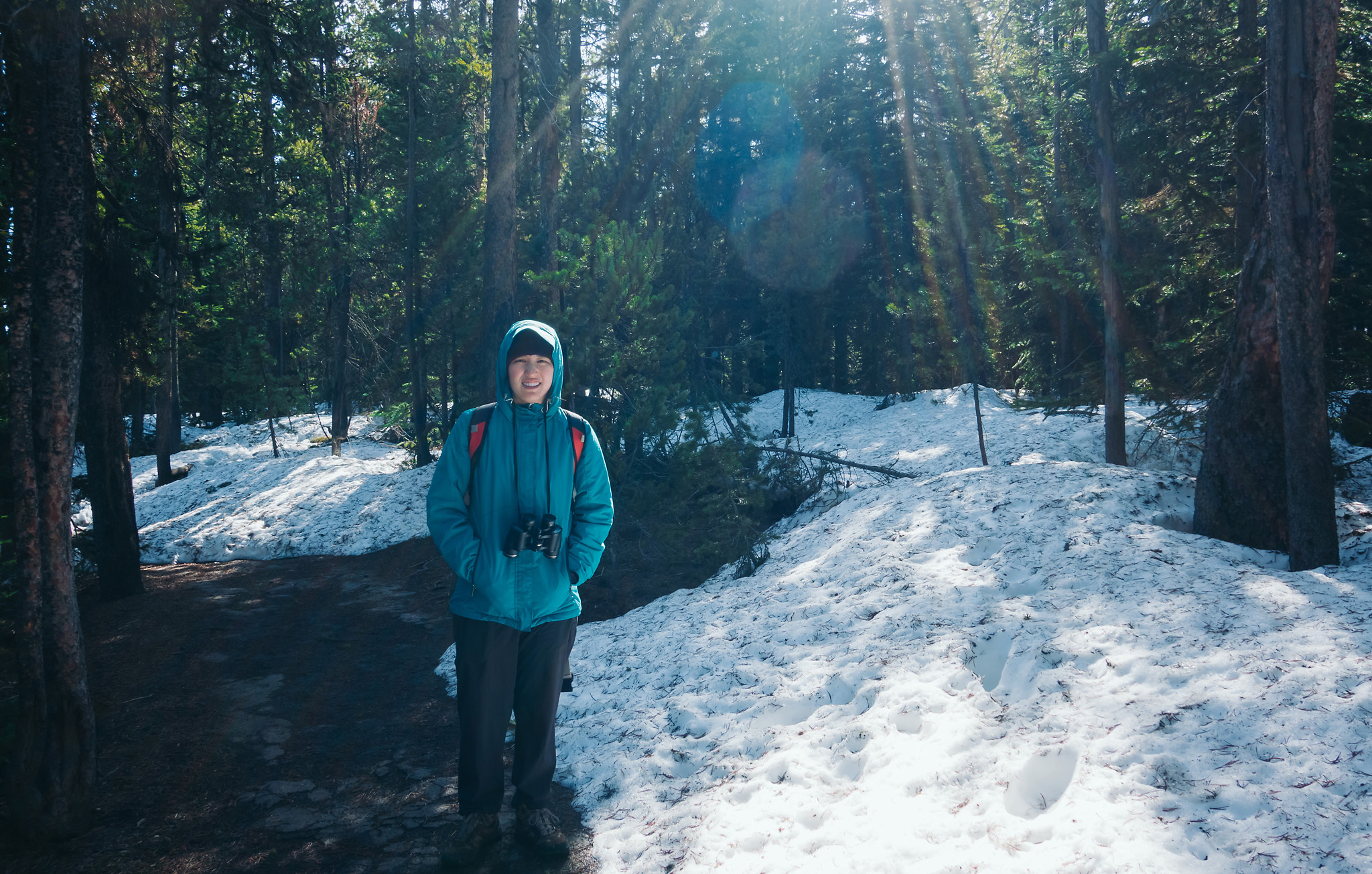
After lunch, we're finally underway on a 50-mile drive through the Absaroka Range to the East Entrance of Yellowstone National Park. Yellowstone itself is situated on an high plateau encircled by mountains. The outline of the old volcano's caldera is still quite apparent from several high points in the park, and the emotional experience of being there occupies a strange middle ground between visiting an amusement park (droves of tourists, themed restaurant menus, gift shops, carefully curated attractions) and sheltering inside a miles-wide geologic blast zone that could devastate the North American continent at any moment. As we drive (as is key in these moments of the trip), Jane falls asleep. We wind alongside rivers and sagebrush-covered canyons in the Wapiti Valley, climbing into the mountains ahead of us through light, passing showers.

In the mid-afternoon, we drive past the frozen surface of Sylvan Lake and over the mountain pass beneath Avalanche Peak, finally laying eyes on Yellowstone Lake, a massive sheet of blue in the caldera below us.  We pause at the overlook on top of Lake Butte, a granite stack close to the eastern shore of the lake, which provides fantastic westward views across the Yellowstone watershed and to the Tetons in the south. Afterward, we continue northwest along the lakeshore, passing through the campsite and general store at Fishing Bridge along the way.  By the roadside near Indian Pond, we catch our first glimpse of the American bison, grazing contentedly at the marsh grass,  its shaggy brown mane flecked with snow.

At the Yellowstone Lake Hotel, Jane waits in the car while I grab the keys to our cabin for the next five nights, a single-room, pastel-yellow affair romantically flanked by snowbanks in the parking lot. We unload our gear and our bags of food, which far outnumber our actual luggage at this point. "Honeymooooning," I croon at Jane while snacking on a potato chip. "Honeymooooning," she croons back as she throws her sweaty socks onto the windowsill. In the early evening, we walk down to the general store beside the lake in our sandals. As the sun disappears, the snow-capped Absarokas, across the water to our east, are bathed in a rosy glow of pinks and purples. We go to sleep early, with - for the first time in a long time - absolutely nowhere to be the next day, or the next day, or the day after that.

Day 2: Canyon

Morning by the lake. The space heater by our door has kept the little log cabin pleasantly warm, though the windows are covered in a layer of frost. After a breakfast of fruit and donuts, Jane and I step out into the blue world and pile into the car to catch our first sunrise in Yellowstone. Driving north,  we follow the course of the Yellowstone River past where it leaves the lake at Fishing Bridge, through the woods, past little hot streams that hiss and smoke as they empty into the current. Near the Mud Volcano geothermal group,  we stop the car and walk down through the trees to a rocky outcrop over the river; the sun rises over the valley to our east, behind the tops of the pines and the skyward plumes of steam.

In the light of day, the mist lying over the land dissolves and disappears as we enter Hayden Valley, a plain of crisscrossing creeks and green meadows formed over the ancient bed of a much larger Yellowstone Lake. Herds of bison graze placidly in the grassy flatlands on either side of the road.  At Trout Creek, we watch as a coyote, panting, chases a young doe across the water and beyond a rocky bluff; I am more entranced, however, by a lovely oxbow bend in the creek, where will we return the following day for sunset. Further north at a turnoff on the valley floor, a wildlife spotter calls us over to his mounted scope; he has spotted a rare grey wolf, one of the few reintroduced to the park in the past few decades, lounging on a hillside to the west of the road. It lets out a low, somber howl, but its packmates - if they are near - give no response. Leaving the valley, the road climbs through the trees to re-join the Yellowstone River at the most dramatic portion of its course.

The Canyon of the Yellowstone is 24-mile gash in the earth formed by the Yellowstone River as it makes the steepest drop on its journey cross-country to join the Missouri River. The result is an immensely beautiful corridor of rocky pinnacles and oxidized rhyolite deposits, capped by the torrential veil of the Lower Yellowstone Falls at the canyon's head.  We leave the car on the South Rim and walk to Artist Point, a rock balcony that juts out from the canyon wall, affording a classic view of the falls and the winding canyon upriver. To our north, the Washburn Range rises imperially toward the big sky. The few tourists on the North Rim (a water main break has cut the Park Loop Road and made the northern half of the park much less accessible for the first few days of our trip) are tiny specks on the opposing canyon wall. We take a few photos together on the balcony, then set off walking along the canyon rim, toward the falls.

Soon after leaving the road, the South Rim Trail climbs and follows to contour of the canyon wall. Though we are in late May, spring has just barely arrived in the Mountain West, and the trail is largely still a snowbank packed several feet deep. Along the most exposed stretches of the climb, where the canyon to our right drops dizzyingly away to the roaring river several hundred feet below, a wooden fence provides an almost laughable veneer of security - a vain piece of amusement park in an utterly wild place. Ignoring the fence, Jane and I hug the inner edge of the trail, tiptoeing our way along the icy snow, and sinking our feet, step by step into the safety of old bootprints.  We reach a gorgeous, snow-free outcrop nearly above the Lower Falls, and sit for a moment to admire the cataract of snowmelt as it rushes into the canyon below.

Beyond this spot, the trail devolves into a snowfield several feet deep and layered with ice. We bend over to read a trail map peeking through the snow to the level of our ankles, which indicates that Uncle Tom's Trail (the famously steep iron staircase that leads down the canyon and to front of the waterfall) is closed, as if we needed any more convincing to stay away from the canyon edge. We turn upslope on the trail, emerging at a parking lot closed for construction.  One of the construction workers chastizingly tells us that we shouldn't be there for our own safety, and nearly turns us back  into the woods before we point out the illogic of making us descend the snowfield for our own safety. He lets us walk out to the road, where a couple from Florida is kind enough to let us hitch a ride in their van back to Artist Point.

Our misadventures on the canyon rim at an end, Jane and I drive back toward the lake, munching on spicy Southwest trail mix and tangerines as we pass through Hayden Valley once again. We stop briefly to walk the boardwalk at the Mud Volcano thermal area, where several pools of vaguely interesting but decidedly unexciting mud froth and bubble and spew at us. We return to the Lake Hotel shortly before noon, stopping  first in the hotel café, where I devour a turkey sandwich and Jane a bowl of minestrone.  After lunch, we take a brief stroll along the lakeside to the general store, where the presence of an ice cream counter is duly noted. Satisfied with this finding, we return to our cabins and settle in for a cozy afternoon nap.

In the late afternoon, we set off again, driving east along the lake to a trailhead at Indian Pond. We follow the meadow path around the edge of the ancient blast crater, skirting around a male bison grazing at the water's edge. As the trail dives into the woods surrounding Storm Point, Jane becomes antsy, urging me to stay close and chafing a bit at my frequent stops for picture-taking. On the north shore of the lake, we are in prime grizzly country, and the prospect of startling a bear in the woods during breeding season is not a pleasant one. It would certainly be a fitting, but unfortunate and fleeting, end to our marriage for one of us be devoured by wildlife during our honeymoon. Fortunately, we are kept company by another hiking family - a father with his two girls, whose shouts of glee ring loud and clear through the pine forest. At Storm Point, we walk out onto a grassy promontory fringed by sand dunes. We sit for a moment on the rocks atop of the point, with Yellowstone Lake stretching away in every direction. "This is a really big volcano," I murmur. Jane is too busy keeping watch for bears to worry about vulcanism. We set off walking along the sand dunes, dodging around another bison grazing in the meadow. Back through another stretch of pine forest - we are startled more than once by the sound of a falling tree branch, or the snap of a twig - and we arrive back at Indian Pond.

In the car, we stop by Fishing Bridge for dinner on the road. I have a tuna salad sandwich; Jane gets turkey and cranberries. We wash these down with strawberry milk, then sit for awhile on the porch outside the gift shop with an ice cream bar, killing time before sunset. As the daylight begins to fade into gold, we climb back in the car and return to the east, to top of Lake Butte, where film to see the sun setting over a sea of burnt trees. I set up for a timelapse while Jane along the road with the spare camera. As the camera snaps away over the following hour, we excitedly try (with our one bar of WiFi here in the Wyoming backcountry) to download an email from Reuben, our wedding photographer, who sent us some previews from our wedding day. As the sun disappears beyond the western edge of the caldera, we pack away the tripod, driving back to our cabin at the lake in the growing dusk.

Day 3: Geyser

Another early morning on the lake. Jane and I head west this time from the Lake Hotel, following the road under Elephant Back Mountain and past the Bridge Bay campground. A pearly pink sunrise is coming over the Absarokas, and from the west shore we can see steam vents rising into the morning air across the lake. In the dim light, we pass the wreckage of a little Volkswagen and a bloody doe carcass; it's hard to say which worse for the wear.  At the tip of West Thumb, the road bifurcates, one way going south to Yellowstone's South Entrance and to the Tetons. We turn the other way, heading over Craig Pass and the Continental Divide to the western half of the Park, and to the world's largest expanse of active geysers and geothermal pools.

We arrive at the Upper Geyser Basin and park beside Old Faithful's classic wooden lodge shortly after 7 AM. The Basin, with its layers of parking mega-lots and fuel pumps, its ring of dining halls and lodges, and its shiny glass visitor center, looks more like a theme park or an airport terminal than a site of raw, wondrous vulcanism. It's still early, and the place is deserted except for a few morning joggers on the boardwalk. No other tripods besides mine. To Jane's and my disappointment respectively, the visitor center bathrooms and ice cream parlour in the lodge are not yet open. The place will gradually liven up as the morning goes on. For now, we set up shop right in front of Old Faithful itself, munching on our Southwest trail mix while my camera clicks off a time lapse.

This is my second time here. The first was in 1998, during my summer vacation after 3rd grade. We stayed in the Old Faithful Inn itself, in a tiny family room with  a communal bathroom out in the hallway, and sallied forth with day trips around the park.  I remember precious little of that trip: flipping through a cross-country trail guide and balking at the distances (I still do).  Fleeting images of pine trees, so many pine trees! A big expanse of water that must have been the Lake. Douglas Wood's recording, Deep Woods, Deep Waters - purchased in a gift shop and first listened to on a rental car stereo - which has stayed with me all these years. The trip was cut short when Evelyn, just over a year old at the time, began running a fever. My parents blamed it on the communal bathroom.  Still, it was nice to be able to lean out the window and see the world's most famous geyser do what it does. That was what I thought of, sitting there on a bench in front of Old Faithful, nineteen years later with my wife.

It's just me, Jane, and one other tourist there when Old Faithful erupts for the first time of the morning. We saunter off to the inn and step into a  log-piled, high-arching atrium, with a roaring fireplace. "How... rustic," Jane murmurs. We both cringe; the word is moderately nauseating after a year of wedding planning. We browse the gift shop and pick out our first fridge magnet of the trip, a nail cutter for the pesky hangnail I've developed on my left pinky toe, and a book on roadside geology in the park. And a scoop of cookies and cream for me. And a sccop of caramel for Jane. We sit outside on the bench and watch another eruption go by while munching thoughtfully on our soon-to-be-daily ice cream ("The honeymoon is a dangerous time," Jane later says prosaically).

After ice cream, we take a stroll to the west along Firehole River, which flows through the geothermal basins of the western park to eventually join the Madison and Missouri Rivers. Looping back through the Upper Geyser Basin along the boardwalks, we pause to peer at the hot pools, steaming and brightly colored with mats of thermophilic bacteria and archaea. The air is rancid with sulphur. By the time we return to Old Faithful's hillside in the mid-morning, a sizeable crowd has surrounded the geyser, and more tourists still, following the countdown timer posted on the visitor center wall, are streaming forward with their children, strollers, and cameras in hand. Suddenly, a boom sounds over the basin, and there is a collective gasp from the crowd as a jet of water erupts from Beehive Geyser,  Old Faithful's neighbor just down the hill and across the river. We stay to watch the two waterspouts put on a rare double performance.

Back in the car, we leave the carnival of the Old Faithful megaplex, driving a few miles down the valley to the Midway Geyser Basin. The parking lot there is crowded as well, and the wind is howling as we cross the bridge over the Firehole River and walk around the enormous crater of Excelsior Geyser, its runoff hissing and steaming as it contacts the river. Curtains of steam from Grand Prismatic Spring, the largest thermal lake in the United States, billow past us on the boardwalk like passing railway cars, and in between clouds we catch glimpses of brilliant cerulean water at the center of the pool, encircled by rims of flaming orange bacterial mats and travertine mineral deposits. Park Loop Road continues parallel to Firehole River until we reach the Lower Geyser Basin, with its bubbling mud pots and exuberant little geysers constantly spouting off beyond the boardwalk.


Next, the road splits at Madison Junction, where the Firehole and Gibbon Rivers join to form the Madison River, which heads westward before curving north toward the plains of western Montana. From there, it skirts around the Yellowstone Plateau to finally and circuitously join with the Atlantic-bound great rivers. We turn east to follow the course of the Gibbon upriver for a few miles, climbing  Tuff Cliff and leaving the volcanic basin behind. At the top of the mountain pass, we reach our turnaround point for the day at Gibbon Falls.

Here, the river rushes over a scarp of granite just below the roadside, plunging from the upland forest of the northern park into the caldera below, striking a band of rock and forming a lovely fantail as it goes. From the overlook, there is a terrific view of the stream winding its way down the canyon past a hillside of blown-down pines. It would be a marvelously idyllic view but for the furious wind, which hurtles down mountains and whips up a flurry of red dirt from the talus slope behind us. We pack away our gear as the ground squirrels and nutcrackers go teetering past, shielding our eyes and our cameras from the sand blast. 

Jane takes a nap as we retrace our long route south and then east (Park Loop Road being still under repair at the Yellowstone Canyon). The hour-and-a-half drive back to the shore of Yellowstone Lake is uneventful, except for a brief pullover to admire a herd of bison grazing on the creekside flats beneath Mary Mountain, and another stop beside Isa Lake near the top of Craig Pass, where we take a selfie astride the Continental Divide. Paradoxically, as with most of the nearby watersheds along the Divide, the lake drains into the Atlantic Ocean via its western waters (by flowing north and then east via the Madison River)  and the Pacific Ocean via its eastern waters (by flowing south to Shoshone Lake and then to the Snake and Colorado Rivers). Interestingly, the road intersects the Divide twice, as the watershed doubles back on itself on the other end of the pass.

When we return to the lakeshore, it all but seems that the wind has pursued us through the geyser basins and over the mountains. It rushes down toward the center of the caldera, beating up whitecaps on Yellowstone Lake, and blowing a rust-colored cloud through the expanse of pine trees and toward the Absarokas. We head over to the general store to re-stock our food supply, and very nearly have to fight to prevent our car doors from being torn off by the gale. A late lunch secured, we beat a hasty retreat to our cabin. Jane has a tuna salad, while I wash down a turkey and cranberry sandwich with a bottle of chocolate milk.  In celebration of the fact that we have nothing better to do, we take another luxurious afternoon nap.

In the early evening, we leave the cabin again, Jane accompanying me for yet another golden hour run. This time, we retrace our way north through Hayden Valley to the Canyon of the Yellowstone. It is just past 7 PM when we reach Artist Point, and the sunset throws a sidelight on the canyon walls, accentuating their hallmark yellow oxides. It takes me 8 bracketed exposures to fully capture the scene upriver: cliffs and spires basking in the golden light, while the falls thunder in the distance beyond a ribbon of winding white river. On our return through the valley, we pause at Trout Creek to photograph the lovely meander of the river, and finally pull over at the valley's southern-most overlook, where I set up a timelapse of the sun sinking into the grassland flats beside the Yellowstone River. One of the lovely things about landscape photography in Yellowstone, as we discover, is the people you meet by standing near a tripod off the side of the road during golden hour. On this evening, we are joined by a tall Ford pickup truck, whose driver is an older man who came from Texas with his grandson. "To see the wolves," he says.  We trade wildlife stories ("Plenty o' coyote," he says with spot-on drawl and a silent 'e', "But none o' those gray wolves we seen settin' 'round here yet.") We tell him about the wolf we saw lazing around the hillside a mile down the valley, and he promises to return in the morning to resume his search.  We stand for awhile on that hilltop over the valley, me with my camera, he and Jane with binoculars glued to their faces - each of us content with the land and the silence and the setting sun.